
Department of Nariño
Departamento de Nariño | |
|---|---|
 Flag  Coat of arms | |
| Motto(s): Desde el mar hasta el Galeras (Spanish: From the sea to the Galeras) | |
| Anthem: Himno del Departamento de Nariño | |
 Nariño shown in red | |
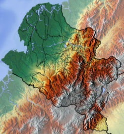 Topography of the department | |
| Coordinates: 01°10′N 77°16′W / 1.167°N 77.267°W | |
| Country | |
| Region | Pacific Region/Andes Region |
| Established | 6 August 1904 |
| Capital | Pasto |
| Government | |
| • Governor | John Rojas (2020-2023) |
| Area | |
| • Total | 33,268 km2 (12,845 sq mi) |
| • Rank | 11th |
| Population (2018)[1] | |
| • Total | 1,630,592 |
| • Rank | 8th |
| • Density | 49/km2 (130/sq mi) |
| GDP | |
| • Total | COP 21,775 billion (US$ 5.1 billion) |
| Time zone | UTC-05 |
| ISO 3166 code | CO-NAR |
| Provinces | 3 |
| Municipalities | 64 |
| HDI (2019) | 0.724[3] high · 24th of 33 |
| Website | [Gobernación http://xn--nario-rta.gov.co/inicio/] |
Nariño (Spanish pronunciation: [naˈɾiɲo]) is a department of Colombia named after independence leader Antonio Nariño. Its capital is Pasto. It is in the west of the country, bordering Ecuador and the Pacific Ocean.
Nariño has a diverse geography and varied climate according to altitude: hot in the plains of the Pacific and cold in the mountains, where most of the population resides, a situation that is repeated in a north-south direction. Other important cities include Tumaco and Ipiales.
YouTube Encyclopedic
-
1/1Views:2 964
-
Departamento de Nariño
Transcription
History
| Year | Pop. | ±% |
|---|---|---|
| 1973 | 809,178 | — |
| 1985 | 1,085,173 | +34.1% |
| 1993 | 1,443,671 | +33.0% |
| 2005 | 1,541,956 | +6.8% |
| 2018 | 1,630,592 | +5.7% |
| Source:[4] | ||
The territory was occupied during the Pre-Columbian era by numerous Indian tribes, including Quillacingas, Awá, Pasto, and Tumas. The first European conquistador who entered the territory was Andagoya Pascual in 1522, who traveled from the Colombian Pacific coast and then used information obtained by Francisco Pizarro to organize the expedition that culminated in the conquest of Peru.
Juan de Ampudia and Pedro de Añazco first explored the mountainous part of the department, commissioned by Sebastián de Belalcázar in 1535, who then toured the territory in 1536 and reached Popayán and remained for some time before leaving for Spain.
Municipalities
- Albán
- Aldana
- Ancuya
- Arboleda
- Barbacoas
- Belén
- Buesaco
- Chachagüí
- Colón (Génova)
- Consaca
- Contadero
- Córdoba
- Cuaspud
- Cumbal
- Cumbitara
- El Charco
- El Peñol
- El Rosario
- El Tablón
- El Tambo
- Francisco Pizarro
- Funes
- Guachucal
- Guaitarilla
- Gualmatán
- Iles
- Imués
- Ipiales
- La Cruz
- La Florida
- La Llanada
- La Tola
- La Unión
- Leiva
- Linares
- Los Andes
- Magüí Payán
- Mallama
- Mosquera
- Nariño
- Olaya Herrera
- Ospina
- Pasto
- Policarpa
- Potosí
- Providencia
- Puerres
- Pupiales
- Ricaurte
- Roberto Payán
- Samaniego
- San Bernardo
- Sandona
- San Lorenzo
- San Pablo
- San Pedro de Cartago
- Santa Bárbara
- Santacruz
- Sapuyes
- Taminango
- Tangua
- Tumaco
- Túquerres
- Yacuanquer
See also
References
- ^ "DANE". Archived from the original on 13 November 2009. Retrieved 13 February 2013.
- ^ "Producto Interno Bruto por departamento", www.dane.gov.co
- ^ "Sub-national HDI - Area Database - Global Data Lab". hdi.globaldatalab.org. Retrieved 13 September 2018.
- ^ "Reloj de Población". DANE. Departamento Administrativo Nacional de Estadísitica. Archived from the original on 16 January 2018. Retrieved 6 July 2017.
External links
- (in Spanish) Government of Narino official website
 | ||
| National | |
|---|---|
| Geographic | |