


The Denmark–Germany border (Danish: Grænsen mellem Danmark og Tyskland; German: Grenze zwischen Dänemark und Deutschland) is 68 kilometres (42 mi) long and separates Denmark and Germany.
History
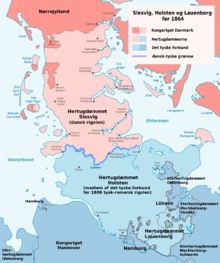
In the treaty of Heiligen year 811 the Eider was recognized as a border between Denmark and the Frankish Empire.[1] As a swampy river, it formed a natural border. On the highest area near the watershed, it was dryer. The very old travel route Hærvejen went there, and a defense wall, Danevirke, was built there. Later the duchies of Schleswig and Holstein arose. Before 1864 Schleswig was a fiefdom of Denmark, while Holstein was a fief of the Holy Roman Empire (until 1806) and a member of the German Confederation (after 1815). Both territories were ruled by the Danish king in his additional role as Duke of Schleswig and Duke of Holstein (occasionally together with other Dukes, like the Gottorp Dukes). The border between the Danish fief of Schleswig and the German fief of Holstein still ran along the Eider, the boundary between the duchies and the Kingdom of Denmark ran along the Kongeåen and the southern boundary of the Danish monarchy (≈Helstaten) ran along the Elbe.
In 1864, Schleswig-Holstein was conquered by Prussia, and so an international border was created between Denmark and Germany/Schleswig-Holstein. It went from a place at the coast 5 kilometres (3.1 mi) south of Ribe, rounded Ribe on 5 kilometres (3.1 mi) distance, then went eastbound just south of Vamdrup, and just north of Christiansfeld to the Baltic Sea.
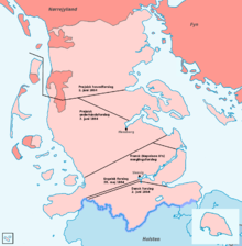
In 1920, the border was moved about 50 kilometres (31 mi) southward to the present position, as determined by the Schleswig referendum in 1920. This approximately followed the not clearly defined language border.
Border controls
In 2001, all border controls were removed based on the Schengen Agreement.
In response to the Swedish border control due to the European migrant crisis, border checks were temporarily introduced starting January 4, 2016. Prime minister Lars Løkke Rasmussen cited fear of accumulation of illegal migrants in Copenhagen as one of the reasons for this decision.[2] It was reported that the border controls at the German border cost the Danish tax payers 1.25 billion DKK (€167 million) from 2016 until mid-2019.[3] They were never fully ended before the COVID-19 pandemic in early 2020,[4] which caused renewed border closures throughout Europe.
To pass the border, an approved travel document is needed. This is mainly a passport. But also a national identity card from the European Economic Area is acceptable, although Denmark does not issue such cards, so a passport is needed for Danes.[5]
Wild boar fence
In January 2019, the Danish government began constructing a fence along the border to keep wild boar, which can carry African swine fever virus, from crossing into Denmark. The 1.5 metres (4.9 ft) high, nearly 70 kilometres (43 mi) long fence—spanning the entire land border—was completed in December 2019 at an estimated cost of 30.4 million Danish kroner.[6][7][8] The fence has created some protests. In May 2019 a volleyball tournament was held over the fence as a publicity event which was given some media attention.[9] After completion there was a decision to raise it by adding wires over it, because animals like deer have been killed after being injured because of jumping over the fence.[10]
-
 Western end of the fence at the Wadden Sea
 -
 Eastern end of the fence in the Flensburg Firth
 -

-
 Gendarmstien passing through the fence at Padborg
Border crossings
| Image | Danish Road/Track Name[11] | German Road/Track Name [11] | Type of crossing [11] | Characteristics[12] | Border checkpoint [12] | Coordinates [11] |
|---|---|---|---|---|---|---|
| Slusevej | - | Road | - | - | 54°54′40″N 8°38′19″E / 54.91115°N 8.63868°E | |
| Siltoftvej | - | Road | Old border checkpoint building | - | 54°54′41″N 8°40′11″E / 54.91131°N 8.6696°E | |
| Rudbølvej | Rosenkranzer-Straße | Road | National speed limits sign | Yes | 54°53′48″N 8°45′01″E / 54.89669°N 8.75033°E | |
| Møllehusvej | (L6) Landesstraße 6 | Road | National speed limits sign | - | 54°54′22″N 8°49′56″E / 54.90608°N 8.83231°E | |
| - | Marschbahn | Track | - | - | 54°53′58″N 8°52′22″E / 54.89938°N 8.87289°E | |
| Road | National speed limits sign | Yes | 54°54′14″N 8°54′37″E / 54.90385°N 8.91034°E | |||
| Vindtvedvej | - | Road | Small sign showing municipality | - | 54°54′00″N 8°57′46″E / 54.89996°N 8.96273°E | |
| Beierskrovej | Beyersweg | Road | Small sign showing municipality | - | 54°53′23″N 8°59′49″E / 54.88975°N 8.99681°E | |
| Pebersmarkvej | (L313) Pepersmarker Weg | Road | National speed limits sign | Yes | 54°52′18″N 9°04′44″E / 54.87165°N 9.07882°E | |
| Grænsevejen | Bögelhuus | Road | National speed limits sign | - | 54°52′23″N 9°08′31″E / 54.87303°N 9.14207°E | |
| Sofiedalvej | Zur Fehle | Road | National speed limits sign | - | 54°50′59″N 9°14′25″E / 54.84984°N 9.24032°E | |
| Kristiansmindevej | Wilmkjerweg | Road | Small sign showing municipality | - | 54°48′11″N 9°17′25″E / 54.80309°N 9.29032°E | |
| Road | National speed limits sign | Yes | 54°48′21″N 9°19′41″E / 54.80574°N 9.32817°E | |||
| Industrivej (Padborg) | (L17) Landesstraße 17 | Road | National speed limits sign | Yes | 54°48′58″N 9°21′40″E / 54.81615°N 9.36112°E | |
| Vamdrup-Padborg-banen | Bahnstrecke Fredericia–Flensburg | Track | - | - | 54°48′55″N 9°21′47″E / 54.81525°N 9.36301°E | |
| Haraldsvej | - | Walking path | - | - | 54°49′02″N 9°21′49″E / 54.8172°N 9.36373°E | |
| Rønsdamvej | - | Walking path | Red-white boom barrier | - | 54°50′02″N 9°22′33″E / 54.8338°N 9.37583°E | |
| - | - | Walking path | - | - | 54°50′20″N 9°23′07″E / 54.83876°N 9.38521°E | |

|
Road | National speed limits sign | Yes | 54°50′22″N 9°24′16″E / 54.83956°N 9.40443°E | ||
| Madeskovvej | Teichweg | Walking path | - | - | 54°50′32″N 9°24′26″E / 54.8422°N 9.40712°E | |
| Skomagerhusvej | Dammweg | Walking path | - | - | 54°49′55″N 9°25′13″E / 54.83198°N 9.42032°E |
See also
References
- ^ Thursten, Tina L. (2001). Landscapes of Power, Landscapes of Conflict: State Formation in the South Scandinavian Iron Age. New York: Kluwer Academic. p. 340. ISBN 0-306-44979-X.
- ^ "Berlingske | Læs nyheder på berlingske.dk".
- ^ Grænsekontrollen har nu kostet mindst 1,25 milliarder kroner
- ^ Nielsen, Nikolaj (2019-12-09). "Revealed: little evidence to justify internal border checks". EUobserver. Archived from the original on 2019-12-12. Retrieved 2021-07-21.
- ^ Rejselegitimation
- ^ "Construction begins on wild boar fence" (Press release). Copenhagen: Ministry of Environment and Food of Denmark. 28 January 2019. Archived from the original on 19 December 2020. Retrieved 29 January 2019.
- ^ Topp, Anders (28 January 2019). "Danmark begynder at bygge hegn mod vildsvin". dr.dk. Danmarks Radio. Retrieved 29 January 2019. (In Danish)
- ^ Walsh, Alistair (28 January 2019). "Denmark starts building anti-swine border fence". dw.com. Deutsche Welle. Retrieved 29 January 2019.
- ^ "Unge spillede volleyball hen over vildsvinehegn". Danmarks Radio (in Danish). 19 May 2019. Retrieved 19 May 2019.
- ^ "Vildsvinehegn bliver ændret for at undgå at skade råvildt" (in Danish). 11 December 2019.
- ^ a b c d See Google Maps for respectively coordinate.
- ^ a b See Google Street View for respectively coordinate.