
| Deeral Queensland | |||||||||||||||
|---|---|---|---|---|---|---|---|---|---|---|---|---|---|---|---|
 Farm with Bellenden Ker Range in the background, 2018 | |||||||||||||||
 Deeral | |||||||||||||||
| Coordinates | 17°13′08″S 145°54′54″E / 17.2188°S 145.915°E | ||||||||||||||
| Population | 151 (2021 census)[1] | ||||||||||||||
| • Density | 5.551/km2 (14.38/sq mi) | ||||||||||||||
| Postcode(s) | 4871 | ||||||||||||||
| Area | 27.2 km2 (10.5 sq mi) | ||||||||||||||
| LGA(s) | Cairns Region | ||||||||||||||
| State electorate(s) | Mulgrave | ||||||||||||||
| Federal division(s) | Kennedy | ||||||||||||||
| |||||||||||||||
Deeral is a town and coastal locality in the Cairns Region, Queensland, Australia.[2][3] In the 2021 census, the locality of Deeral had a population of 151 people.[1]
YouTube Encyclopedic
-
1/1Views:434
-
QRNational's 2390 + 1732D haul #3930 (The Sunlander) between Aloomba and Deeral.
Transcription
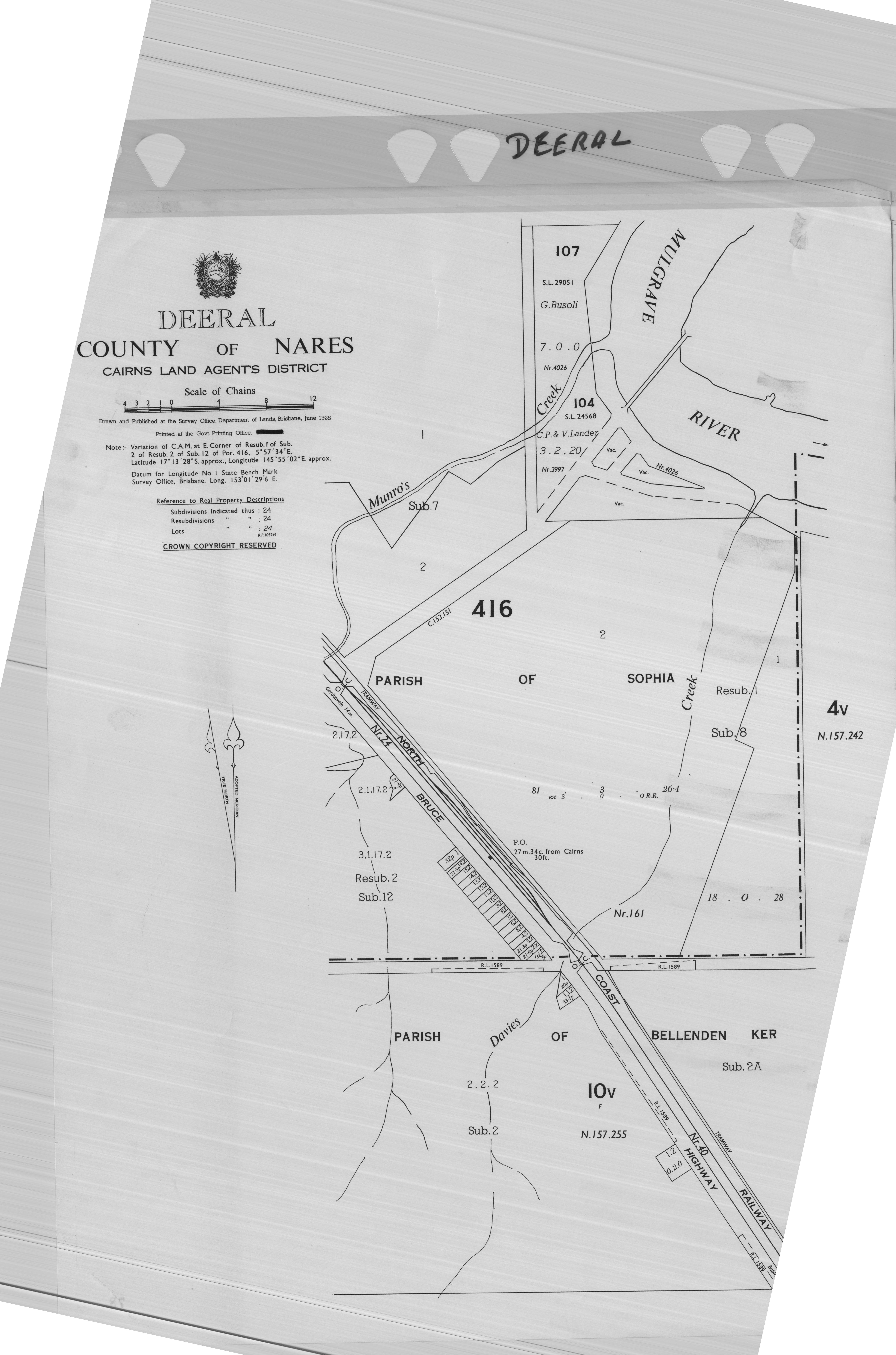
Geography

Deeral has an unusual "J"-shape boundaries. The eastern part is a long section of beach facing the Coral Sea and its immediate hinterland; this land is undeveloped and controlled by the Queensland Government. The western part is a curved section of freehold land, cleared and used for farming especially sugarcane. Both of these areas are low-lying (less than 10 metres above sea level). In the very far west of the locality the land begins rising rapidly towards the adjacent Bellenden Ker Range in neighbouring Wooroonooran; this land is undeveloped.[4]
The town is located in the south-western part of the locality. The Bruce Highway and the North Coast railway line traverse the locality, adjacent and parallel, from the south-west of the locality through to the north-west of the "curve of the J", passing through the town, which is served by the Deeral railway station (known as Munros Camp railway station from 1883 to 1912).[4][5]
The Mulgrave River forms the north-eastern boundary of the "curve", then cross the locality to form the southern boundary of the eastern beach part of the locality entering the Coral Sea at that point.[4]
History
The town was built on Yidinji tribal territory. The town's name was derived from its railway station's name which was named Deeral in 1912, an Aboriginal word in the Yidinyji language meaning teeth.[2]
Demographics
In the 2016 census, the locality of Deeral had a population of 141 people.[6]
In the 2021 census, the locality of Deeral had a population of 151 people.[1]
Community groups
The Deeral branch of the Queensland Country Women's Association meets at the CWA Hall at 68925 Bruce Highway.[7]
References
- ^ a b c Australian Bureau of Statistics (28 June 2022). "Deeral (SAL)". 2021 Census QuickStats. Retrieved 28 February 2023.
- ^ a b "Deeral – town in Cairns Region (entry 9664)". Queensland Place Names. Queensland Government. Retrieved 30 July 2017.
- ^ "Deeral – locality in Cairns Region (entry 48601)". Queensland Place Names. Queensland Government. Retrieved 30 July 2017.
- ^ a b c "Queensland Globe". State of Queensland. Retrieved 30 July 2017.
- ^ "Deeral – railway station in Cairns Region (entry 39180)". Queensland Place Names. Queensland Government. Retrieved 30 July 2017.
- ^ Australian Bureau of Statistics (27 June 2017). "Deeral (SSC)". 2016 Census QuickStats. Retrieved 20 October 2018.
- ^ "Branch Locations". Queensland Country Women's Association. Archived from the original on 26 December 2018. Retrieved 26 December 2018.
External links
- "Deeral". Queensland Places. Centre for the Government of Queensland, University of Queensland.
- Town map of Deeral, 1968