
| Daymar Queensland | |||||||||||||||
|---|---|---|---|---|---|---|---|---|---|---|---|---|---|---|---|
 Daymar | |||||||||||||||
| Coordinates | 28°36′22″S 148°59′03″E / 28.6061°S 148.9841°E | ||||||||||||||
| Population | 37 (2016 census locality)[1] | ||||||||||||||
| • Density | 0.0668/km2 (0.1731/sq mi) | ||||||||||||||
| Postcode(s) | 4497 | ||||||||||||||
| Area | 553.7 km2 (213.8 sq mi) | ||||||||||||||
| Time zone | AEST (UTC+10:00) | ||||||||||||||
| Location |
| ||||||||||||||
| LGA(s) | Goondiwindi Region | ||||||||||||||
| State electorate(s) | Southern Downs | ||||||||||||||
| Federal division(s) | Maranoa | ||||||||||||||
| |||||||||||||||
Daymar is a rural town and locality in the Goondiwindi Region, Queensland, Australia.[2][3] In the 2016 census, the locality of Daymar had a population of 37 people.[1]
YouTube Encyclopedic
-
1/2Views:811382
-
New Students Practicing Prenatal Massage at Charter College
-
Massage Courses Gold Coast - Call Us Today! 07 5576 6366
Transcription
Geography
The town is on the South Western railway line, with the town being served by the Daymar railway station (28°36′13″S 148°59′06″E / 28.6035°S 148.9849°E).[4][5]
The land use is a mix of crops and grazing on native vegetation.[4]
History
The town takes its name from the railway station, which in turn was named by Queensland Railways Department on 15 September 1911, and is thought to be an Aboriginal word, meaning red ridge.[2]
Daymar Provisional School opened on 11 March 1946, becoming Daymar State School in 1952. In 1977-1978 the closed Kurumbul State School's building was relocated from Kurumbul to Daymar State School.[6]
It closed on 9 December 1983.[7] It was in Waugh Street opposite the railway station (28°36′18″S 148°59′02″E / 28.6049°S 148.9838°E).[8]
Amenities
The Thallon-Daymar branch of the Queensland Country Women's Association has its rooms at 47 William Street in neighbouring Thallon in the Shire of Balonne, 12 kilometres (7.5 mi) to the west of Daymar.[9]
Our Lady of Lourdes Catholic Church is in Waugh Street (28°36′17″S 148°59′04″E / 28.6047°S 148.9844°E); services are held on the first Sunday of each month.[10]
In the 2016 census, the locality of Daymar had a population of 37 people.[1]
Education
There are no schools in Daymar. The nearest primary school is Thallon State School in neighbouring Thallon to the west. The nearest secondary schools are Dirranbandi State School (to Year 10) in Dirranbandi to the west and St George State High School (to Year 12) in St George to the north-west. Given the distances to these secondary schools, distance education and boarding school would be other options.[4]
References
- ^ a b c Australian Bureau of Statistics (27 June 2017). "Daymar (SSC)". 2016 Census QuickStats. Retrieved 20 October 2018.
- ^ a b "Daymar – town in Goondiwindi Region (entry 9478)". Queensland Place Names. Queensland Government. Retrieved 23 October 2020.
- ^ "Daymar – locality in Goondiwindi Region (entry 47807)". Queensland Place Names. Queensland Government. Retrieved 23 October 2020.
- ^ a b c "Queensland Globe". State of Queensland. Retrieved 27 October 2020.
- ^ "Railway stations and sidings - Queensland". Queensland Open Data. Queensland Government. 27 August 2020. Archived from the original on 5 October 2020. Retrieved 5 October 2020.
- ^ "Item ID593341, Relocation of Kurrumbul School at Daymar together with alterations and additions, Daymar State School". Queensland State Archives. Retrieved 23 March 2021.
- ^ Queensland Family History Society (2010), Queensland schools past and present (Version 1.01 ed.), Queensland Family History Society, ISBN 978-1-921171-26-0
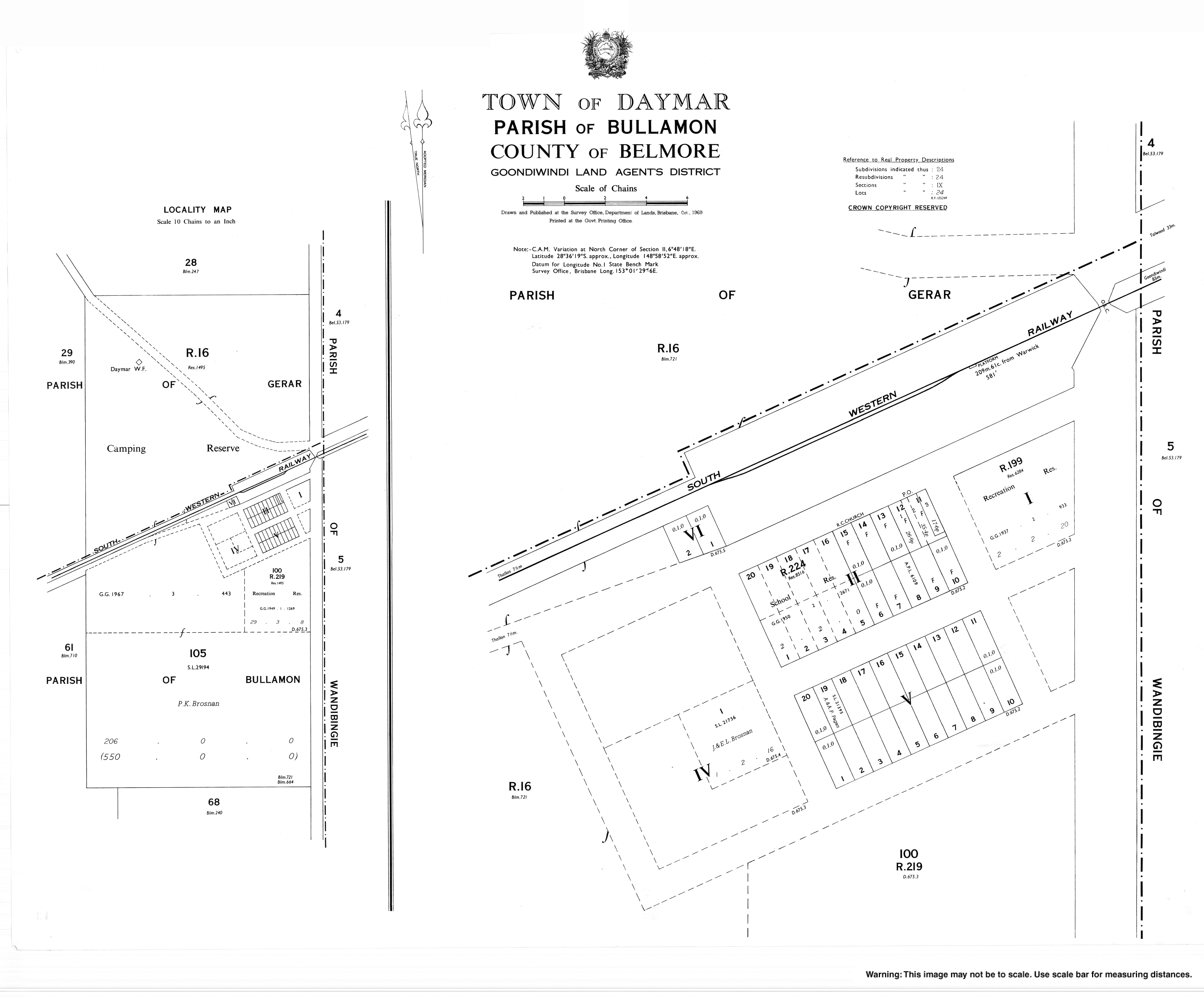
- ^ "Daymar" (Map). Queensland Government. 1969. Archived from the original on 27 October 2020. Retrieved 27 October 2020.
- ^ "Branch locations". Queensland Country Women's Association. Archived from the original on 26 December 2018. Retrieved 26 December 2018.
- ^ "Our Lady of Lourdes Church, Daymar". Roman Catholic Diocese of Toowoomba. Archived from the original on 27 October 2020. Retrieved 27 October 2020.