To install click the Add extension button. That's it.

The source code for the WIKI 2 extension is being checked by specialists of the Mozilla Foundation, Google, and Apple. You could also do it yourself at any point in time.

4,5
Kelly Slayton
Congratulations on this excellent venture… what a great idea!
Alexander Grigorievskiy
I use WIKI 2 every day and almost forgot how the original Wikipedia looks like.
What we do. Every page goes through several hundred of perfecting techniques; in live mode. Quite the same Wikipedia. Just better.
.
Leo
Newton
Brights
Milds

From Wikipedia, the free encyclopedia

Curaçá
Municipality
The Municipality of Curaçá
Flag of Curaçá
Official seal of Curaçá
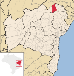
Localization of the city
Coordinates: 08°59′31″S 39°54′28″W / 8.99194°S 39.90778°W / -8.99194; -39.90778
CountryBrazil
RegionNortheast
StateBahia
FoundedJuly 6, 1832
Government
 • MayorPedro Oliveira (2016-2020)
Area
 • Total6,442.190 km2 (2,487.343 sq mi)
Population
 (2020 [1])
 • Total34,886
 • Density4.9/km2 (13/sq mi)
Time zoneUTC−3 (BRT)
HDI (2010)0.700 – high[2]
Websitewww.curaca.ba.gov.br

Curaçá is the northernmost city in the Brazilian state of Bahia.

The municipality was designated a priority area for conservation and sustainable use when the Caatinga Ecological Corridor was created in 2006.[3]

YouTube Encyclopedic

  • 1/1
    Views:
    990
  • Feriado na Ilha da coroa, Curaçá-Ba

Transcription

References

  1. ^ IBGE 2020
  2. ^ [1] UNDP
  3. ^ Mattos, Marluza (2006), Ministério cria Corredor Ecológico da Caatinga (in Portuguese), Ministério do Meio Ambiente, retrieved 2016-11-01
This page was last edited on 6 June 2021, at 15:18
Basis of this page is in Wikipedia. Text is available under the CC BY-SA 3.0 Unported License. Non-text media are available under their specified licenses. Wikipedia® is a registered trademark of the Wikimedia Foundation, Inc. WIKI 2 is an independent company and has no affiliation with Wikimedia Foundation.