
| Csanád County | |
|---|---|
| County of the Kingdom of Hungary (11th century-1542) County of the Eastern Hungarian Kingdom (1542-1552) County of the Kingdom of Hungary (1699-1786, 1790-1853, 1860-1923, 1945-1946) County of the Second Hungarian Republic (1946-1949) County of the Hungarian People's Republic (1949-1950) | |
 Coat of arms
| |
 | |
| Capital | Marosvár (Csanád) 1028- ; Makó (1730-1950) |
| Area | |
| • Coordinates | 46°13′N 20°29′E / 46.217°N 20.483°E |
• 1910 | 1,714 km2 (662 sq mi) |
| Population | |
• 1910 | 145,248 |
| History | |
• Established | 11th century |
• Ottoman conquest | 1552 |
• County recreated | 1699 |
• Merged into Békés-Csanád-Csongrád County | 1 June 1786 |
• County recreated | 26 April 1790 |
• Merged into Békés-Csanád County | 10 January 1853 |
• County recreated | 20 October 1860 |
• Treaty of Trianon | 4 June 1920 |
• Merged into Csanád-Arad-Torontál County | 1923 |
• County recreated | 1945 |
• Disestablished | 16 March 1950 |
| Today part of | Hungary (1,469 km2) Romania (245 km2) |
| Cenad is now the name of the former capital. | |
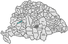
Csanád was an administrative county (comitatus) of the Kingdom of Hungary. Its territory is now part of Hungary, except for a small area which is part of Romania. The capital of the county was Makó.
Geography

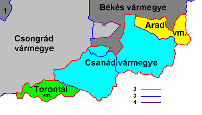
Csanád county shared borders with the Hungarian counties of Csongrád, Békés, Arad and Torontál. The river Maros (Mureș) formed its southern border. Its area was 1,714 km2 around 1910.
History
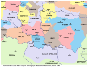
The county's territory became part of the Kingdom of Hungary in the first half of the 11th century when Stephen I of Hungary defeated Ajtony, the local ruler. The county got its name after the commander of the royal army, Csanád. The king appointed Gerard of Csanád as the first bishop of Csanád. The county was initially much larger and included territories of the later Temes, Arad, and Torontál counties. The first seat of the county was Csanád (present-day Cenad, Romania).
The county's territory became part of the Ottoman Empire in the 16th century. The settlement structure was almost completely destroyed during the Ottoman-Habsburg wars. In the Treaty of Karlowitz, the Ottoman Empire renounced its claims to the territories north of the Maros (Mureș) river. Csanád county was reorganized in the returned territories (with greatly reduced size than in medieval times). Makó became the seat of the reorganized county.
After World War I, the county was occupied by the Romanian army. In 1920, the Treaty of Trianon assigned a small area in the southeast of the county (the town of Nădlac and the villages of Șeitin, Turnu and Dorobanți) to Romania. The rest of the county was united with parts of Torontál county (a small area south of Szeged) and Arad county (a small area south of Békéscsaba) to form the new county of Csanád-Arad-Torontál in 1923.
After World War II, the county was recreated, but in 1950 it was divided between the Hungarian counties of Békés and Csongrád (since 4 June 2020, the latter was renamed to Csongrád-Csanád County). The Romanian part of the former Csanád county is now part of Arad County.
Demographics

Csanád county was one of the most densely populated counties of the Kingdom of Hungary. The Hungarians formed an ethnic majority in every district except for the district of Nagylak. The main part of the Slovaks lived in the district of Nagylak, the Romanians lived mostly in the districts of Nagylak and Battonya, while the Serbs lived in the district of Battonya.
| Census | Total | Hungarian | Slovak | Romanian | Serbian | German | Other or unknown |
|---|---|---|---|---|---|---|---|
| 1880[1] | 109,011 | 75,344 (72.74%) | 12,433 (12.00%) | 11,099 (10.72%) | 3,186 (3.08%)[b] | 1,111 (1.07%) | 404 (0.39%) |
| 1890[2] | 130,575 | 95,229 (72.93%) | 15,735 (12.05%) | 13,689 (10.48%) | 3,853 (2.95%) | 1,410 (1.08%) | 659 (0.50%) |
| 1900[3] | 140,007 | 103,242 (73.74%) | 17,274 (12.34%) | 13,982 (9.99%) | 3,981 (2.84%) | 1,182 (0.84%) | 346 (0.25%) |
| 1910[4] | 145,248 | 108,621 (74.78%) | 17,133 (11.80%) | 14,046 (9.67%) | 3,967 (2.73%) | 1,013 (0.70%) | 468 (0.32%) |
| Census | Total | Roman Catholic | Calvinist | Lutheran | Eastern Orthodox | Greek Catholic | Jewish | Other or unknown |
|---|---|---|---|---|---|---|---|---|
| 1880 | 109,011 | 53,634 (49.20%) | 21,706 (19.91%) | 12,820 (11.76%) | 13,679 (12.55%) | 4,133 (3.79%) | 2,887 (2.65%) | 152 (0.14%) |
| 1890 | 130,575 | 65,991 (50.54%) | 24,751 (18.96%) | 16,298 (12.48%) | 15,994 (12.25%) | 4,362 (3.34%) | 3,000 (2.30%) | 179 (0.14%) |
| 1900 | 140,007 | 71,610 (51.15%) | 25,234 (18.02%) | 18,384 (13.13%) | 16,567 (11.83%) | 4,520 (3.23%) | 3,254 (2.32%) | 438 (0.31%) |
| 1910 | 145,248 | 76,075 (52.38%) | 24,897 (17.14%) | 19,095 (13.15%) | 16,851 (11.60%) | 4,438 (3.06%) | 3,353 (2.31%) | 539 (0.37%) |
Subdivisions

In the early 20th century, the subdivisions of Csanád county were:
| Districts (járás) | |
|---|---|
| District | Capital |
| Battonya | Battonya |
| Központ | Makó |
| Mezőkovácsháza | Mezőkovácsháza |
| Nagylak | Nagylak (now Nădlac) |
| Urban districts (rendezett tanácsú város) | |
| Makó | |
The town of Nădlac is now in Romania; the other towns mentioned are now in Hungary.

Notes
References
- ^ "Az 1881. év elején végrehajtott népszámlálás főbb eredményei megyék és községek szerint rendezve, II. kötet (1882)". library.hungaricana.hu. Archived from the original on 2021-10-17. Retrieved 2021-09-28.
- ^ "A Magyar Korona országainak helységnévtára (1892)". library.hungaricana.hu. Archived from the original on 2021-10-17. Retrieved 2021-09-29.
- ^ "A MAGYAR KORONA ORSZÁGAINAK 1900". library.hungaricana.hu. Archived from the original on 2021-10-17. Retrieved 2021-09-29.
- ^ "KlimoTheca :: Könyvtár". Kt.lib.pte.hu. Archived from the original on 2021-10-17. Retrieved 2021-09-29.

External links
Heraldry [1]