
Cruz del Eje Department
Departamento Cruz del Eje | |
|---|---|
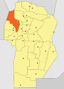 Location of Cruz del Eje Department in Córdoba Province | |
| Coordinates: 30°43′S 64°44′W / 30.717°S 64.733°W | |
| Country | |
| Province | |
| Capital | Cruz del Eje |
| Area | |
| • Total | 6,653 km2 (2,569 sq mi) |
| Population | |
| • Total | 52,172 |
| • Density | 7.8/km2 (20/sq mi) |
| • Pop. change (1991-2001) | +7.24% |
| Time zone | UTC-3 (ART) |
| Postal code | X5280 |
| Dialing code | 03549 |
| Distances to | |
| Buenos Aires | 861 km (535 mi) |
| Córdoba | 151 km (94 mi) |
Cruz del Eje Department is a department of Córdoba Province in Argentina.
The provincial subdivision has a population of about 52,172 inhabitants in an area of 6,653 km², and its capital city is Cruz del Eje, which is located around 861 km from Capital Federal.
YouTube Encyclopedic
-
1/3Views:6 4485 50529 121
-
Cruz del Eje it's possible
-
BOMBEROS DE PENJAMO EN ACCION COLECTA 2012.wmv
-
Mompox, Rio Magdalena Sur Bolivar, Costa Caribe Colombia - Como viajar, que visitar ?
Transcription
Settlements
- Alto de Los Quebrachos
- Bañado de Soto
- Cruz de Caña
- Cruz del Eje
- El Brete
- Guanaco Muerto
- La Batea
- La Higuera
- Las Cañadas
- Las Playas
- Los Chañaritos
- Media Naranja
- Paso Viejo
- San Marcos Sierras
- Serrezuela
- Tuclame
- Villa de Soto
1908 earthquake
On 22 September 1908 the region was struck by an earthquake measuring 6.5 on the Richter scale. The epicentre was around 30°30′0″S 64°30′0″W / 30.50000°S 64.50000°W and it was felt as far as 100 km away.
This article about a place in Córdoba Province, Argentina is a stub. You can help Wikipedia by expanding it. |