
Colneis[pronunciation?] is a hundred of Suffolk, consisting of 16,712 acres (67.63 km2).[1]
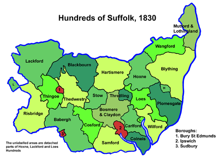
Running from the south-east outskirts of Ipswich to the North Sea coast, the hundred is made up of the land between the estuaries of the rivers Orwell and Deben. It is one of the smallest in Suffolk, being only about four miles (6.4 km) wide and ten miles (16 km) long between its border with Carlford Hundred and the cliffs at Felixstowe. It lies within the Colneis Deanery, in the Archdeaconry of Suffolk. It was one of seven Saxon hundreds grouped together as the Wicklaw Hundreds.[2]
Listed as Colneyse in the Domesday Book, the origin of the name is not known for sure, though the suffix -ness, meaning "headland" seems probable. The col may be the old name of the Deben before its renaming after Debenham.[3]
The name survives as that of a Junior School in Felixstowe.
Parishes
Colneis Hundred consists of the following 10 parishes:[1][4]
| Parish | Area (acres) |
|---|---|
| Bucklesham | 1800 |
| Falkenham | 1550 |
| Felixstowe | 1170 |
| Hemley | 1155 |
| Kirton | 1929 |
| Levington | 1660 |
| Nacton | 2380 |
| Trimley St Martin | 1200 |
| Trimley St Mary | 1868 |
| Walton | 2000 |
References
- ^ a b William White (1844). History, gazetteer, and directory of Suffolk. p. 119.
- ^ Williamson, Tom (2018). "New Light on Rendlesham". The Historian (139). The Historical Association.
- ^ Walter Skeat (1913). The Place-names of Suffolk.
- ^ 1841 Census
| Hundreds | |
|---|---|
| Boroughs outside a hundred | |
52°00′N 1°18′E / 52.0°N 1.3°E
This Suffolk location article is a stub. You can help Wikipedia by expanding it. |