To install click the Add extension button. That's it.
The source code for the WIKI 2 extension is being checked by specialists of the Mozilla Foundation, Google, and Apple. You could also do it yourself at any point in time.
How to transfigure the Wikipedia
Would you like Wikipedia to always look as professional and up-to-date? We have created a browser extension. It will enhance any encyclopedic page you visit with the magic of the WIKI 2 technology.
Try it — you can delete it anytime.
Install in 5 seconds
Yep, but later
4,5
Kelly Slayton
Congratulations on this excellent venture… what a great idea!
Alexander Grigorievskiy
I use WIKI 2 every day and almost forgot how the original Wikipedia looks like.
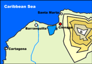
In this satellite image, the Ciénaga Grande de Santa Marta is the greenish area at top, bordered by the Caribbean Sea on the left.
The Ciénaga Grande de Santa Marta (Spanish for Large Marsh of Saint Martha) is the largest of the swampy marshes located in Colombia between the Magdalena River and the Sierra Nevada de Santa Marta. It has an area of 4280 km2 and belongs to the outer delta system of the Madgalena River.[2] It is separated from the Caribbean Sea by a narrow, sandy artificial spit built in the 1950s,[3] on which is situated coastal route 90 from Barranquilla to Santa Marta. The marsh's large lagoon is connected to the Caribbean Sea via a narrow strait (the La Barra channel) located between the town of Pueblo Viejo and the city of Ciénaga.
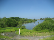
Vegetation by the Ciénaga Grande de Santa Marta near the town of Ciénaga
Source: Wills, Fernando; et al. (2001). Nuestro patrimonio – 100 tesoros de Colombia [Our heritage – 100 treasures of Colombia] (in Spanish). El Tiempo. pp. 1–311. ISBN958-8089-16-6.


