

Following is a list of glaciers of Bouvet Island in Antarctica. This list may not reflect recently named glaciers in Bouvet Island.
YouTube Encyclopedic
-
1/3Views:1 17827 93977 100
-
Bouvet Island
-
7 Facts about the cold & isolated Heard Island and McDonald Islands
-
Most MYSTERIOUS Uninhabited Islands!
Transcription
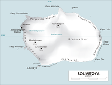
Christensen Glacier
54°26′53″S 3°21′09″E / 54.4481°S 3.3525°E.[a] A glacier which flows to the south coast of Bouvetøya, 1 nautical mile (1.9 km; 1.2 mi) east of Cato Point. First charted in 1898 by a German expedition under Karl Chun. Recharted in December 1927 by a Norwegian expedition under Capt. Harald Horntvedt. Named by Horntvedt after Lars Christensen, sponsor of the expedition. Not: Christensenbreen, Christensens Bre.[1]
Horntvedt Glacier
54°25′S 3°21′E / 54.417°S 3.350°E. A small glacier flowing to the north coast of Bouvetøya immediately east of Cape Circoncision. First charted in 1898 by a German expedition under Karl Chun. Recharted in December 1927 by a Norwegian expedition which named it for Harald Horntvedt, captain of the expedition ship Norvegia. Not: Horntvedtbreen, Horntvedts Bre.[2]
Posadowsky Glacier
54°25′S 3°22′E / 54.417°S 3.367°E. A glacier which flows to the north coast of Bouvetøya, 1 nautical mile (1.9 km; 1.2 mi) eastward of Cape Circoncision. First charted and named by a German expedition under Karl Chun which visited the island in the Valdivia in 1898. Count Arthur von Posadowsky-Wehner, Imperial Home Secretary, was instrumental in obtaining government sponsorship of the expedition. Not: Posadowskybreen, Posadowskys Bre.[3]
Notes
- ^ The coordinates 54°26′53″S 3°21′09″E / 54.4481°S 3.3525°E are derived from Google Maps. Alberts (1995) gives 54°28′S 3°24′E / 54.467°S 3.400°E, which is a point in the sea some distance south of the island.[1]
References
- ^ a b Alberts 1995, p. 134.
- ^ Alberts 1995, p. 346.
- ^ Alberts 1995, p. 585.
Sources
- Alberts, Fred G., ed. (1995), Geographic Names of the Antarctic (PDF) (2 ed.), United States Board on Geographic Names, retrieved 2023-12-27
 This article incorporates public domain material from websites or documents of the United States Board on Geographic Names.