
Chop
Чоп Csap | |
|---|---|
 Railway station in Chop | |
 Flag  Coat of arms | |
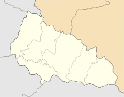 Chop Location of Chop  Chop Chop (Ukraine) | |
| Coordinates: 48°25′50″N 22°12′00″E / 48.43056°N 22.20000°E | |
| Country | |
| Oblast | Zakarpattia Oblast |
| Raion | Uzhhorod Raion |
| Hromada | Chop urban hromada |
| Government | |
| • Mayor | Galina Car |
| Elevation | 103 m (338 ft) |
| Population (2022) | |
| • Total | 8,626 |
| Time zone | UTC+1 (CET) |
| • Summer (DST) | UTC+2 (CEST) |
| Postal code | 89500 — 89509 |
| Area code | +380 22 |
| Climate | Cfb |
| Sister cities | Milove (Ukraine) Sokołów Małopolski, (Poland) Záhony (Hungary) |
| Website | chop-rada |
Chop (Ukrainian: Чоп, Hungarian: Csap, Slovak: Čop, Rusyn: Чоп, Yiddish: טשאָפּ) is a city located in Zakarpattia Oblast (province) of western Ukraine, near the borders of Slovakia and Hungary. It is separated from the Hungarian town of Záhony by the river Tisza by being situated on its right bank. It is located within Uzhhorod Raion. Today, the population is 8,626 (2022 estimate).[2]
YouTube Encyclopedic
-
1/3Views:3 8661 006680
-
Border Crossing by Train - Chop Ukraine into Hungary.MOV
-
"Ukraine border crossing at Chop" Steeneveld's photos around Chop, Ukraine (immigration uzhhorod)
-
Pass Zahony-Chop. Gruz Chop-Cierna nad Tisou. Ukraine, Chop.
Transcription
Toponymy
There are several alternative names used for this city: Hungarian: Csap, Slovak: Čop, German: Tschop, Romanian: Ciop, Polish: Czop, Russian: Чоп, Yiddish: טשאָפּ.
History

Like the rest of Transcarpathia, Chop was part of Hungary until 1920, when, as a result of the post-World War I Treaty of Trianon, it was included in the newly created Czechoslovakia, where it belonged to Slovakia, not to Subcarpathian Rus. During World War II, under the First Vienna Award, it briefly became Hungarian again. But, after the war, as part of the Czechoslovakia–Soviet Union relations, it became part of the expanded Ukrainian Soviet Socialist Republic (now Ukraine).
Demographics
According to the Ukrainian national census, Chop had a population in 2001 of 8,919, of whom 40% were Ukrainians, 39.2% ethnic Hungarians and 20.8% Roma, Russians, Slovaks, Belarusians, and Jews.
Features


Chop is an important railway junction in Ukraine where the Lviv-Stryi-Budapest railway line meets the Lviv-Uzhhorod-Košice line. There is also a line running eastwards to Romania via Korolevo and Halmeu although there are currently no regular passenger services.
Near Chop, there are also international railway and highway border crossings to Hungary and Slovakia and also to the westernmost point of Ukraine. The first town across the border in Slovakia is Čierna nad Tisou while in Hungary, the first city is Záhony.
Notable people
- András Pándy, serial killer
- J. Peters, political activist
See also
References
- ^ "Chop (Zakarpattia Oblast, Uzhhorod Raion)". weather.in.ua (in Ukrainian). Retrieved 25 December 2018.
- ^ Чисельність наявного населення України на 1 січня 2022 [Number of Present Population of Ukraine, as of January 1, 2022] (PDF) (in Ukrainian and English). Kyiv: State Statistics Service of Ukraine. Archived (PDF) from the original on 4 July 2022.
External links
- Chop in the Encyclopedia of Ukraine
- Chop (Чоп) of Ukraine 1:100,000 topographic maps
- Chop - ShtetLink
| Authority control databases: National |
|---|
48°26′N 22°12′E / 48.433°N 22.200°E