
Castlereagh Lower
| |
|---|---|
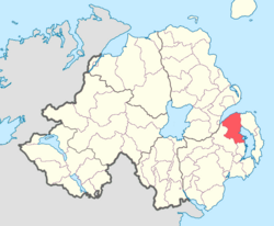 Location of Castlereagh Lower, County Down, Northern Ireland. | |
| Sovereign state | United Kingdom |
| Country | Northern Ireland |
| County | Down |
Castlereagh Lower (named after the former barony of Castlereagh) is a historic barony in County Down, Northern Ireland.[2] It was created by 1841 with the division of Castlereagh into two.[3] The barony roughly matches the former Gaelic territory of Uí Blathmaic, anglicized Blathewic.[4] It is bordered by three other baronies: Ards Lower to the east; Dufferin to the south; and Castlereagh Upper to the west and south-west.[2] Castlereagh Lower is also bounded by Belfast Lough to the north and Strangford Lough to the south-east.
List of settlements
Below is a list of settlements in Castlereagh Lower:[5]
Towns
- Bangor (also partly in barony of Ards Lower)
- Comber
- Holywood
- Newtownards (also partly in barony of Ards Lower)
Villages
- Ardmillan
- Ballygowan
- Crawfordsburn
Population centres
List of civil parishes
Below is a list of civil parishes in Castlereagh Lower:[5][6][7]
- Bangor (also partly in barony of Ards Lower)
- Comber (also partly in barony of Castlereagh Upper)
- Dundonald
- Holywood
- Killinchy (also partly in baronies of Castlereagh Upper and Dufferin)
- Kilmood
- Knockbreda (also partly in barony of Castlereagh Upper)
- Newtownards (also partly in barony of Ards Lower)
- Tullynakill
References
- ^ "Cary". Placenames Database of Ireland. Department of Community, Rural and Gaeltacht Affairs. Retrieved 24 May 2015.
- ^ a b PRONI Baronies of Northern Ireland
- ^ "Database of Irish Historical Statistics - Literacy Notes" (PDF). Archived from the original (PDF) on 12 March 2016. Retrieved 24 May 2015.
- ^ O'Laverty, James (1878). "The Territory of the Ards". An Historical Account of the Diocese of Down and Conor, Ancient and Modern. p.64. Quote: "Their territory extended from the vicinity of Bangor to that of Carrickmannon, and included the modern civil parishes of Holywood, Dundonald, Comber, Killinchy, Kilmood, Tullynakill, with parts of Bangor, Newtownards, and Knock-breda."
- ^ a b "Castlereagh Lower". IreAtlas Townlands Database. Retrieved 15 May 2015.
- ^ "Baronies and parishes of County Down". Archived from the original on 17 February 2010. Retrieved 24 May 2015.
- ^ "PRONI Civil Parishes of County Down". Archived from the original on 27 July 2011. Retrieved 24 May 2015.
