
Capital City Airport | |||||||||||||||
|---|---|---|---|---|---|---|---|---|---|---|---|---|---|---|---|
 | |||||||||||||||
| Summary | |||||||||||||||
| Airport type | Public | ||||||||||||||
| Owner/Operator | Susquehanna Area Regional Airport Authority | ||||||||||||||
| Serves | Harrisburg, Pennsylvania | ||||||||||||||
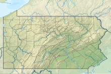
| Location | Fairview Township, York County, near New Cumberland, Pennsylvania | ||||||||||||||
| Elevation AMSL | 347 ft / 106 m | ||||||||||||||
| Coordinates | 40°13′02″N 076°51′05″W / 40.21722°N 76.85139°W | ||||||||||||||
| Website | www.flycxy.com | ||||||||||||||
| Maps | |||||||||||||||
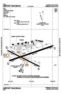 FAA diagram | |||||||||||||||
 CXY  CXY | |||||||||||||||
| Runways | |||||||||||||||
| |||||||||||||||
| Statistics (2023) | |||||||||||||||
| |||||||||||||||
Capital City Airport (IATA: HAR, ICAO: KCXY, FAA LID: CXY) is a public airport in Fairview Township, York County, Pennsylvania, three miles (5 km) southeast of Harrisburg, the capital of Pennsylvania.[1]
Most U.S. airports use the same three-letter location identifier for the FAA and IATA, but Capital City Airport is CXY to the FAA and HAR to the IATA (which assigned CXY to Cat Cays Airport, Bimini Islands, Bahamas.)
YouTube Encyclopedic
-
1/3Views:381501797
-
World War II airplanes at the Capital City Airport in Pennsylvania
-
Defiant N22VL approach to Capital City Airport KCXY
-
Comair CRJ-200 Takeoff from Lansing Capital City Airport
Transcription
Overview
The airport is the home airport for the Pennsylvania Bureau of Aviation and the Pennsylvania State Police.[2] It averages more than 57,000 corporate, charter, and private aircraft operations a year. Owned and operated by the Susquehanna Area Regional Airport Authority (SARAA), Capital City Airport is the designated reliever and sister airport of Harrisburg International Airport, and serves Dauphin, Cumberland, and York counties.
A study by the PA Department of Transportation in 2000 concluded that Capital City Airport related activities generate nearly $24 million a year in economic output.
Facilities


Capital City Airport covers 320 acres (130 ha) and has two asphalt runways: 8/26 is 5,000 x 150 ft (1,524 x 46 m) and 12/30 is 3,778 x 100 ft (1,152 x 30 m).[1]
In the year ending May 3, 2023, the airport had 27,348 aircraft operations, average 75 a day: 88% general aviation, 10% military, and 2% air taxi. 97 aircraft were based at the airport: 74 single-engine, 13 multi-engine, 6 jet, and 4 military.[3]
History
Originally Capital Landing Field, the airport opened in mid-1930 and was Harrisburg's first airline airport. On October 25, 1930, a Ford Trimotor airplane flying the first transcontinental air mail stopped at the airport.[4] In 1934 the Commonwealth of Pennsylvania purchased it and renamed it Harrisburg-York State Airport. It was a stop on longer air routes, principally between Pittsburgh and Philadelphia. The airline was Transcontinental and Western Airlines which became TWA and remained until 1968. (DC-9s replaced TWA's last Constellations in 1967; the 4970-ft runway was one of the shortest in the country to see airline jets.) Allegheny and Capital/United appeared in the 1940s; United pulled out in 1966.
In the 1940s the airport handled war materials for the former adjacent New Cumberland Army Depot and hosted the Naval Photographic Reconnaissance Training School. The Army Air Corps stationed the 101st and 103d Observation Squadrons at Harrisburg early in the war to train pilots in observation and aerial photography. Later the Army Air Force formed the 6th Fighter Wing and 47th Bombardment Wing at the airport before their deployment overseas. New Cumberland Army depot remains although it has gone through several name changes over the years. It has been known as Defense Distribution Center (DDC) New Cumberland, Defense Distribution Region East (DDRE), and the Defense Distribution Supply Point (DDSP) Susquehanna. Currently it is known as the Defense Logistics Agency (DLA) Susquehanna, one of the largest military distribution centers for supplies and equipment for the U.S. Armed Forces
Olmsted Air Force Base, just across the river in Middletown was also close, and in 1968 Allegheny and TWA moved there to newly named Harrisburg International Airport. Capital City Airport then got its current name and became a general aviation airport.
Since 1999 Capital City Airport has been owned and operated by the Susquehanna Area Regional Airport Authority (SARAA). CXY is the designated reliever and sister airport of Harrisburg International Airport, and serves Dauphin, Cumberland, and York counties.
Accidents near CXY
- On December 25, 1944, a USAAF Douglas C-47 crashed on approach when it flew into the side of a hill, 5km (3.1 miles) SW of CXY. Twelve occupants out of 27 on board were killed.[5]
See also
References
- ^ a b c FAA Airport Form 5010 for CXY PDF
- ^ "Harrisburg Jet Center: Capital City Airport". Archived from the original on June 5, 2007. Retrieved November 3, 2007.
- ^ "Capital City Airport". AirNav. Federal Aviation Administration. Retrieved March 5, 2016.
- ^ "Art & Imagery". Historical Society of Dauphin County. Retrieved May 10, 2021.
- ^ Accident description for 42-23360 at the Aviation Safety Network. Retrieved on September 29, 2023.
External links
- Capital City Airport
- Capital City Airport at Pennsylvania Bureau of Aviation
- FAA Airport Diagram (PDF), effective January 25, 2024
- Resources for this airport:
- FAA airport information for CXY
- AirNav airport information for KCXY
- ASN accident history for HAR
- FlightAware airport information and live flight tracker
- NOAA/NWS weather observations: current, past three days
- SkyVector aeronautical chart, Terminal Procedures
- Volo Aviation Fixed-Base Operator
40°13′13″N 76°51′17″W / 40.22032°N 76.85468°W