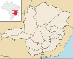
Campo Belo | |
|---|---|
 View of Campo Belo's main square | |
| Motto(s): Portuguese: União, Ordem e Progresso (Union, Order and Progress) | |
 Location in Brazil | |
| Coordinates: 20°53′49″S 45°16′37″W / 20.89694°S 45.27694°W | |
| Country | |
| Region | Southeast |
| State | Minas Gerais |
| Mesoregion | West of Minas Gerais |
| Microregion | Campo Belo |
| Founded | 1879 |
| Government | |
| • Mayor | Tulio Miguel |
| Area | |
| • Total | 528.225 km2 (203.949 sq mi) |
| Elevation | 945.0 m (3,100.4 ft) |
| Population (2020 [1]) | |
| • Total | 54,186 |
| • Density | 97.58/km2 (252.7/sq mi) |
| Demonym | Campo-belense[2] |
| Time zone | UTC-3 (BRT) |
| • Summer (DST) | UTC-2 (BRST) |
| HDI (2010) [3] | 0.711 |
| Website | Campo Belo, Minas Gerais |
Campo Belo (Portuguese for "beautiful field") is a city located in Minas Gerais state, in Brazil. The estimated population in 2020 was 54,186 inhabitants, and the total area of the municipality was 528.225 square kilometres (203.949 sq mi). It was founded in 1879.
YouTube Encyclopedic
-
1/5Views:5171 03427 1882 04116 503
-
CAMPO BELO RESORT - ÁLVARES MACHADO / SÃO PAULO
-
BAIRRO CAMPO BELO | SÃO PAULO
-
Campo Belo MG (Fotos)
-
CAMPO BELO MG
-
Campo Belo, Melhor Cidade do Brasil!❤️
Transcription
Geography
Climate
Campo Belo's climate can be classified as tropical altitude, with yearly average temperature of 23.5 °C (74.3 °F). The Köppen climate classification of the region is Cwa (Tropical on high altitudes, humid/warm summer and a dry/cool winter).
| Campo Belo | ||||||||||||||||||||||||||||||||||||||||||||||||||||||||||||
|---|---|---|---|---|---|---|---|---|---|---|---|---|---|---|---|---|---|---|---|---|---|---|---|---|---|---|---|---|---|---|---|---|---|---|---|---|---|---|---|---|---|---|---|---|---|---|---|---|---|---|---|---|---|---|---|---|---|---|---|---|
| Climate chart (explanation) | ||||||||||||||||||||||||||||||||||||||||||||||||||||||||||||
| ||||||||||||||||||||||||||||||||||||||||||||||||||||||||||||
| ||||||||||||||||||||||||||||||||||||||||||||||||||||||||||||
Soil
- Silic - Clay.
Topography
- Plain : 15%
- Waivy : 55%
- Mountain: 30%
References
- ^ IBGE 2020
- ^ "IBGE - Cidades@". O Brasil Município por Município. Brazilian Institute of Geography and Statistics (IBGE). Retrieved 2015-05-27.
- ^ "Ranking decrescente do IDH-M dos municípios do Brasil" [Ranking of HDI-M of Brazilian Municipalities] (PDF) (in Portuguese). United Nations Development Programme (UNDP). 2010. Retrieved 2013-08-03.


