
| Calle-Calle River Gudalafquén (Mapudungun) | |
|---|---|
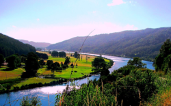 View of Calle-Calle River a few kilometers upstream from Valdivia | |
| Native name | Río Calle-Calle (Spanish) |
| Location | |
| Country | Chile |
| Physical characteristics | |
| Source | |
| • location | San Pedro River |
| Mouth | |
• location | Valdivia River |
| Length | 55 km (34 mi)[1] |
Calle-Calle River, also called Gudalafquén in Mapuche language, is a river in Valdivia Province, southern Chile. It drains waters from the San Pedro River to the Valdivia River, which in turn flows into Corral Bay on the Pacific Ocean.
The river's name derives from the Mapuche word for the flower Libertia chilensis.[2]
The Calle-Calle is among the few rivers in Chile that are considered navigable. The Calle-Calle and Santa Elvira bridges crosses the river in the city of Valdivia.
The city of Valdivia obtains most of its water supply from Calle-Calle River near Cuesta Soto. Decreasing precipitation has caused the river to be contaminated with saline water from the coast.[3] The effects of saline water entering the water supply of Valdivia were particularly noticeable in 2015 when there was a surge in complains about the taste of the water.[3][4] The saltwater in the rivers near Valdivia during autumn is expected to increase in the future.[4] Estimations indicate that whenever the sum of the water discharge of Cruces and Calle-Calle rivers falls below 74 m3/s (2,600 cu ft/s) saltwater reaches the supply site at Cuesta Soto.[4]

References
- ^ "Cuenca del río Valdivia" (PDF). Archived from the original (PDF) on 2007-09-27. Retrieved 2007-10-28.
- ^ "Historia". Museo de Sitio Castillo de Niebla (in Spanish). Servicio Nacional del Patrimonio Cultural. Archived from the original on 2020-08-04. Retrieved 2021-04-01.
- ^ a b Jara, Yonatan; Stuardo, Manuel (2020-09-21). "Científicos proyectan en 80 años la llegada de mar a toma de agua en Valdivia para buscar soluciones". Radio Bío-Bío (in Spanish). Retrieved 2022-03-07.
- ^ a b c Lara, Emilio (2020-09-16). "El mar se acerca a principal toma de agua dulce en Valdivia y amenaza calidad del recurso". Radio Bío-Bío (in Spanish). Retrieved 2022-03-07.
39°48′07″S 73°12′45″W / 39.80194°S 73.21250°W
This Los Ríos Region location article is a stub. You can help Wikipedia by expanding it. |
This article related to a river in Chile is a stub. You can help Wikipedia by expanding it. |