To install click the Add extension button. That's it.

The source code for the WIKI 2 extension is being checked by specialists of the Mozilla Foundation, Google, and Apple. You could also do it yourself at any point in time.

4,5
Kelly Slayton
Congratulations on this excellent venture… what a great idea!
Alexander Grigorievskiy
I use WIKI 2 every day and almost forgot how the original Wikipedia looks like.
Live Statistics
English Articles
Improved in 24 Hours
Added in 24 Hours
Languages
Recent
Show all languages
What we do. Every page goes through several hundred of perfecting techniques; in live mode. Quite the same Wikipedia. Just better.
.
Leo
Newton
Brights
Milds

California statistical areas

From Wikipedia, the free encyclopedia

Map of the 34 core-based statistical areas in California.
An enlargeable map of the 34 core-based statistical areas in California.[1]

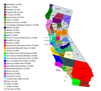
The U.S. State of California currently has 39 statistical areas that have been delineated by the federal Office of Management and Budget (OMB). On March 6, 2020, the OMB delineated five combined statistical areas, 26 metropolitan statistical areas, and eight micropolitan statistical areas in California.[1]

YouTube Encyclopedic

  • 1/5
    Views:
    166 490
    8 941
    237 455
    100 741
    26 668
  • Which U.S. city is the closest to a true regional government?
  • Top 10 Statistics Schools in the World
  • Why You Need to Study Statistics
  • Where is the densest place in the United States?
  • How Does El Niño Affect California?

Transcription

Statistical areas

The Office of Management and Budget (OMB) has designated more than 1,000 statistical areas for the United States and Puerto Rico.[2] These statistical areas are important geographic delineations of population clusters used by the OMB, the United States Census Bureau, planning organizations, and federal, state, and local government entities.

The OMB defines a core-based statistical area (commonly referred to as a CBSA) as "a statistical geographic entity consisting of the county or counties (or county-equivalents) associated with at least one core[a] of at least 10,000 population, plus adjacent counties having a high degree of social and economic integration with the core as measured through commuting ties with the counties containing the core."[2] The OMB further divides core-based statistical areas into metropolitan statistical areas (MSAs) that have "a population of at least 50,000" and micropolitan statistical areas (μSAs) that have "a population of at least 10,000, but less than 50,000."[2]

The OMB defines a combined statistical area (CSA) as "a geographic entity consisting of two or more adjacent core-based statistical areas with employment interchange measures[b] of at least 15%."[2] The primary statistical areas (PSAs) include all combined statistical areas and any core-based statistical area that is not a constituent of a combined statistical area.

Table

The table below describes the 39 United States statistical areas and 58 counties of the State of California with the following information:[3]

  1. The combined statistical area (CSA) as designated by the OMB.[1]
  2. The CSA population according to the 2020 US Census.[4]
  3. The core based statistical area (CBSA)[2] as designated by the OMB.[1]
  4. The CBSA population according to the 2020 US Census.[4]
  5. The county name.
  6. The county population according to the 2020 US Census.[4]
  7. The Metropolitan Division name, if applicable[1]
  8. The Metropolitan Division population according to 2019 US Census Bureau population estimates [4]
The 39 United States statistical areas and 58 counties of the State of California

Combined Statistical Area 2020 Population Core Based Statistical Area 2020 Population County 2020 Population Metropolitan Division 2020 Population
Los Angeles–Long Beach, CA CSA 18,644,680 Los Angeles–Long Beach–Anaheim, CA MSA 13,200,998 Los Angeles County, California 10,014,009 Los Angeles-Long Beach-Glendale, CA MD 10,014,009
Orange County, California 3,186,989 Anaheim-Santa Ana-Irvine, CA MD 3,186,989
Riverside–San Bernardino–Ontario, CA MSA 4,599,839 Riverside County, California 2,418,185 none
San Bernardino County, California 2,181,654
Oxnard-Thousand Oaks-Ventura, CA MSA 843,843 Ventura County, California 843,843
San Jose-San Francisco-Oakland, CA CSA 9,714,023 San Francisco–Oakland–Berkeley, CA MSA 4,749,008 Alameda County, California 1,682,353 Oakland-Berkeley-Livermore, CA MD 2,848,280
Contra Costa County, California 1,165,927
San Francisco County, California 873,965 San Francisco-San Mateo-Redwood City, CA MD 1,638,407
San Mateo County, California 764,442
Marin County, California 262,321 San Rafael, CA MD 262,321
San Jose-Sunnyvale-Santa Clara, CA MSA 2,000,468 Santa Clara County, California 1,936,259 none
San Benito County, California 64,209
Stockton, CA MSA 779,233 San Joaquin County, California 779,233
Modesto, CA MSA 552,878 Stanislaus County, California 552,878
Santa Rosa-Petaluma, CA MSA 488,863 Sonoma County, California 488,863
Vallejo, CA MSA 453,491 Solano County, California 453,491
Merced, CA MSA 281,202 Merced County, California 281,202
Santa Cruz-Watsonville, CA MSA 270,861 Santa Cruz County, California 270,861
Napa, CA MSA 138,019 Napa County, California 138,019
none San Diego-Chula Vista-Carlsbad, CA MSA 3,298,634 San Diego County, California 3,298,634
Sacramento-Roseville, CA CSA 2,680,831 Sacramento-Roseville-Folsom, CA MSA 2,397,382 Sacramento County, California 1,585,055
Placer County, California 404,739
Yolo County, California 216,403
El Dorado County, California 191,185
Yuba City, CA MSA 181,208 Sutter County, California 99,633
Yuba County, California 81,575
Truckee-Grass Valley, CA μSA 102,241 Nevada County, California 102,241
Fresno-Madera-Hanford, CA CSA 1,317,395 Fresno, CA MSA 1,008,654 Fresno County, California 1,008,654
Madera, CA MSA 156,255 Madera County, California 156,255
Hanford-Corcoran, CA MSA 152,486 Kings County, California 152,486
none Bakersfield, CA MSA 909,235 Kern County, California 909,235
Visalia, CA MSA 473,117 Tulare County, California 473,117
Santa Maria-Santa Barbara, CA MSA 448,229 Santa Barbara County, California 448,229
Salinas, CA MSA 439,035 Monterey County, California 439,035
San Luis Obispo-Paso Robles, CA MSA 282,424 San Luis Obispo County, California 282,424
Redding-Red Bluff, CA CSA 247,984 Redding, CA MSA 182,155 Shasta County, California 182,155
Red Bluff, CA μSA 65,829 Tehama County, California 65,829
none Chico, CA MSA 211,632 Butte County, California 211,632
El Centro, CA MSA 179,702 Imperial County, California 179,702
Eureka-Arcata, CA μSA 136,463 Humboldt County, California 136,463
Ukiah, CA μSA 91,601 Mendocino County, California 91,601
Clearlake, CA μSA 68,163 Lake County, California 68,163
Sonora, CA μSA 55,620 Tuolumne County, California 55,620
Susanville, CA μSA 32,730 Lassen County, California 32,730
Crescent City, CA μSA 27,743 Del Norte County, California 27,743
none Calaveras County, California 45,292
Siskiyou County, California 44,076
Amador County, California 40,474
Glenn County, California 28,917
Colusa County, California 21,839
Plumas County, California 19,790
Inyo County, California 19,016
Mariposa County, California 17,131
Trinity County, California 16,112
Mono County, California 13,195
Modoc County, California 8,700
Sierra County, California 3,236
Alpine County, California 1,204
State of California 39,538,223

See also

Notes

  1. ^ The OMB defines a core as "a densely settled concentration of population, comprising an Urban Area (of 10,000 or more population) delineated by the Census Bureau, around which a core-based statistical area is delineated."[2]
  2. ^ The OMB defines the employment interchange measure as "the sum of the percentage of workers living in the smaller entity who work in the larger entity plus the percentage of employment in the smaller entity that is accounted for by workers who reside in the larger entity."[2]

References

  1. ^ a b c d e Revised Delineations of Metropolitan Statistical Areas, Micropolitan Statistical Areas, and Combined Statistical Areas, and Guidance on Uses of the Delineations of These Areas (March 6, 2020). "0MB BULLETIN NO. 20-01" (PDF). Office of Management and Budget. Retrieved December 6, 2021.{{cite web}}: CS1 maint: multiple names: authors list (link)
  2. ^ a b c d e f g "2020 Standards for Delineating Core Based Statistical Areas". Office of Management and Budget. July 16, 2021. Retrieved December 6, 2021.
  3. ^ An out-of-state area and its population are displayed in green. An area that extends into more than one state is displayed in teal. A teal population number over a black population number show the total population versus the in-state population.
  4. ^ a b c d "2020 Census Redistricting Data". United States Census Bureau. September 2021. Retrieved January 9, 2022.

External links

37°11′03″N 119°28′11″W / 37.1841°N 119.4696°W / 37.1841; -119.4696 (State of California)

This page was last edited on 30 January 2023, at 06:57
Basis of this page is in Wikipedia. Text is available under the CC BY-SA 3.0 Unported License. Non-text media are available under their specified licenses. Wikipedia® is a registered trademark of the Wikimedia Foundation, Inc. WIKI 2 is an independent company and has no affiliation with Wikimedia Foundation.