
State Route 187 | ||||
|---|---|---|---|---|
| Venice Boulevard | ||||
 Map of Los Angeles County in southern California with SR 187 highlighted in red | ||||
| Route information | ||||
| Maintained by Caltrans | ||||
| Length | 5.405 mi[1] (8.699 km) | |||
| Major junctions | ||||
| West end | ||||
| East end | ||||
| Location | ||||
| Country | United States | |||
| State | California | |||
| Counties | Los Angeles | |||
| Highway system | ||||
| ||||

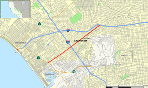
State Route 187 (SR 187) is a state highway in the U.S. state of California that runs along Venice Boulevard in Los Angeles from Lincoln Boulevard (State Route 1) in Venice to Interstate 10 in the South Robertson district.
YouTube Encyclopedic
-
1/5Views:1 2434 6573269 90214 985
-
Driving from Venice to Culver City, Venice Boulevard, CA 187
-
Driving from Venice Beach to Downtown Los Angeles via Venice Boulevard- 4K
-
Driving from to Culver City to Los Angeles, California State Highway Route 90
-
En route to a pc187 Felony stop
-
CA-152: The Pacheco Pass Highway, Santa Nella to Gilroy
Transcription
Route description

Proceeding easterly, Venice Boulevard assumes the designation California State Route 187 at Lincoln Boulevard (State Route 1). The route then passes through the Mar Vista neighborhood. Further east, it briefly forms the boundary between Palms and Culver City and passes near Sony Pictures Studios. Continuing northeast into the South Robertson neighborhood of Los Angeles, the SR 187 designation terminates at the intersection with Cadillac Avenue and the ramp carrying traffic from westbound I-10.[2]
SR 187 is part of the National Highway System,[3] a network of highways that are considered essential to the country's economy, defense, and mobility by the Federal Highway Administration.[4]
History
Route 163 was defined in 1961 as a route from the ocean in Santa Monica to Route 173, routed along Pacific Avenue and Venice Boulevard.[5] This was redefined as SR 187 in the 1964 state highway renumbering.[6] In 1988, the part of SR 187 in Santa Monica was removed from the state highway system.[7] The part of the route from the southern boundary of Santa Monica to Lincoln Boulevard was removed in 1994.[8]
Future
According to Section 487 of the California Streets and Highways Code, the entire length of Route 187 is eligible for relinquishment to the City of Los Angeles. If a relinquishment occurs, the state highway will cease to exist.
In popular culture
Rapper Snoop Dogg posed in front of a SR 187 sign in 1993, as a reference to Section 187 of the California Penal Code that defines the crime of murder and the song with Dr. Dre that he collaborated with (the shield has since been removed). [9][10]
Major intersections
Except where prefixed with a letter, postmiles were measured on the road as it was in 1964, based on the alignment that existed at the time, and do not necessarily reflect current mileage. R reflects a realignment in the route since then, M indicates a second realignment, L refers to an overlap due to a correction or change, and T indicates postmiles classified as temporary ().[1] Segments that remain unconstructed or have been relinquished to local control may be omitted. The entire route is in Los Angeles, Los Angeles County.
| Postmile [1][11][12] | Destinations | Notes | |||
|---|---|---|---|---|---|
| 3.50 | Venice Boulevard – Venice Beach | Continuation beyond SR 1 | |||
| 3.50 | Former US 101 Alt.; west end of SR 187 | ||||
| 4.78 | Centinela Avenue | ||||
| 5.83 | Interchange; I-405 exit 52; former SR 7 | ||||
| 5.91 | Sepulveda Boulevard | ||||
| 6.62 | Overland Avenue | ||||
| 7.63 | Culver Boulevard | ||||
| 8.64 | La Cienega Boulevard | ||||
| 8.80 | Interchange; I-10 exit 7A (as La Cienega Boulevard eastbound); east end of SR 187 | ||||
| 8.91 | Cadillac Avenue, Venice Boulevard | Continuation beyond I-10 | |||
| 1.000 mi = 1.609 km; 1.000 km = 0.621 mi | |||||
See also
References
- ^ a b c California Department of Transportation. "State Truck Route List". Sacramento: California Department of Transportation. Archived from the original (XLS file) on June 30, 2015. Retrieved June 30, 2015.
- ^ Los Angeles County Road Atlas (Map). Thomas Brothers. 2008.
- ^ Federal Highway Administration (March 25, 2015). National Highway System: Los Angeles, CA (PDF) (Map). Scale not given. Washington, DC: Federal Highway Administration. Retrieved September 16, 2017.
- ^ Natzke, Stefan; Neathery, Mike & Adderly, Kevin (June 20, 2012). "What is the National Highway System?". National Highway System. Washington, DC: Federal Highway Administration. Retrieved July 1, 2012.
- ^ California State Assembly. "1961 Session of the Legislature". 1961 Session of the Legislature. Statutes of California. State of California. Ch. 1840.
- ^ California State Assembly. "An act to add Section 253 and Article 3 (commencing with Section 300) to Chapter 2 of Division 1 of, and to repeal Section 253 and Article 3 (commencing with Section 300) of Chapter 2 of Division 1 of, the..." 1963 Session of the Legislature. Statutes of California. State of California. Ch. 385 p. 1182.
- ^ California State Assembly. "An act to add and repeal Sections...of the Government Code, to amend Sections...of, the Streets and Highways Code..." 1987–1988 Session of the Legislature. Statutes of California. State of California. Ch. 106.
- ^ California State Assembly. "An act to amend Section 2982.2 of, and to add Section 3068.2 to, the Civil Code, to amend Sections 40084.5, 40088, and 40089 of the Education Code, to amend Section 29601 of, to amend and renumber Section 14035.6 of, to..." 1993–1994 Session of the Legislature. Statutes of California. State of California. Ch. 1220.
- ^ "25 Mar 1993, Los Angeles, California, USA — Snoop Doggy Dogg standing at the Route 187 sign in Los Angeles, California". Snoop Dogg - Hip Hop Golden Age. HipHopGoldenAge. Retrieved 31 July 2022.
- ^ "Approximate location of where the SR 187 shield once stood". Google Maps. Retrieved 31 July 2022.
- ^ California Department of Transportation (July 2007). "Log of Bridges on State Highways". Sacramento: California Department of Transportation.
- ^ California Department of Transportation, All Traffic Volumes on CSHS, 2005 and 2006
External links
- Caltrans: State Route 187 highway conditions
- Caltrans Traffic Conditions Map
- California Highway Patrol Traffic Incidents
- California @ AARoads.com - State Route 187
- California Highways: SR 187