
State Route 128 | ||||
|---|---|---|---|---|
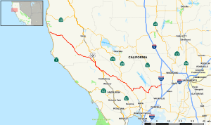 Map of western California with SR 128 highlighted in red | ||||
| Route information | ||||
| Maintained by Caltrans | ||||
| Length | 120.52 mi[1] (193.96 km) | |||
| Major junctions | ||||
| West end | ||||
| ||||
| East end | ||||
| Location | ||||
| Country | United States | |||
| State | California | |||
| Counties | Mendocino, Sonoma, Napa, Solano, Yolo | |||
| Highway system | ||||
| ||||

State Route 128 (SR 128) is a state highway in the U.S. state of California, connecting the Mendocino coast to the Sacramento Valley, through the state's Wine Country. It runs from State Route 1 near Albion to Interstate 505 in Winters.
YouTube Encyclopedic
-
1/5Views:1 4233038491 023824
-
Driving California Highway 128
-
Driving from San Jose to Mendocino Part 2 | State Route 128
-
California State Route 128, Anderson Valley, CA
-
California State Route 128 - October 22 2013
-
California State Route 130 Scenic Drive in 4K
Transcription
Route description


Route 128 begins at Route 1 near the mouth of the Navarro River at the Pacific Ocean. The highway travels southeast and upriver, through the coast redwood forests of Navarro River Redwoods State Park and through the vineyards and apple orchards of the Anderson Valley, to Boonville. Route 253, from Ukiah, has its western terminus into Route 128 at the south end of Boonville. Leaving Boonville, Route 128 climbs out of the Navarro River watershed and crosses the Yorkville Highlands before descending into the Russian River watershed, arriving at Cloverdale in the Alexander Valley, where the highway joins U.S. Route 101 heading south.
A few miles later, at Geyserville, Route 128 separates from U.S. 101 and continues southeast through Knights Valley on the way to Napa Valley, where it joins Route 29 at Calistoga. After passing through the town of St. Helena, Route 128 splits from Route 29 at Rutherford and climbs east over dry ridges above Lake Berryessa to the Sacramento Valley. In Winters, the route's constructed portion ends at Interstate 505. By its legal definition, the route continues 14 mi (23 km) east along Road 93A and Covell Blvd to Route 113 at Davis and then Mace Blvd to Interstate 80, but this segment is currently not constructed.
The section of Route 128 through Navarro River Redwoods State Park is often closed in winter storms due to flooding.[2] Two slower alternate routes are available: the Philo-Greenwood road connects Route 1 near Elk to Route 128 near Hendy Woods State Park, a few miles north of Philo;[3] another alternate route is the Comptche-Ukiah Road, which intersects Route 1 just south of the town of Mendocino and runs inland to Comptche, and departs Comptche on Flynn Creek Road, intersecting Route 128 just up river from the seasonal flood gate closing the highway.
SR 128 is part of the California Freeway and Expressway System,[4] although it is mostly 2 lanes, but except for a small portion in Winters is not part of the National Highway System,[5] a network of highways that are considered essential to the country's economy, defense, and mobility by the Federal Highway Administration.[6]
History
The main road through the Anderson Valley to the mouth of the Navarro River, and from there up the coast to Fort Bragg, was originally called the Navarro Highway; it follows the approximate route of the present Route 128 and Route 1 through Mendocino County. Even earlier, the road followed the Navarro Ridge, to the north of the present alignment, instead of staying at the river level.[7] By 1938, the last stretches of old winding roadway near the present location of Navarro were replaced by a straighter alignment, taken over from a disused logging railway line.[8]
Before being numbered as California State Route 128, the highway was signed as State Route 28. In 1952 it was renumbered State Route 128, permitting a different highway around Lake Tahoe to be numbered as Route 28 to coordinate its numbering with Nevada Route 28.[9]
Major intersections
Except where prefixed with a letter, postmiles were measured on the road as it was in 1964, based on the alignment that existed at the time, and do not necessarily reflect current mileage. R reflects a realignment in the route since then, M indicates a second realignment, L refers to an overlap due to a correction or change, and T indicates postmiles classified as temporary ().[10] Segments that remain unconstructed or have been relinquished to local control may be omitted. The numbers reset at county lines; the start and end postmiles in each county are given in the county column.
| County | Location | Postmile [10][1][11] | Exit [12] | Destinations | Notes | |||
|---|---|---|---|---|---|---|---|---|
| Mendocino MEN 0.00-50.90 | | 0.00 | West end of SR 128 | |||||
| Boonville | 29.58 | West end of SR 253 | ||||||
| Sonoma SON 0.00-24.76 | | | North Cloverdale Boulevard (US 101 Bus. south, SR 128 Bus. east) – Cloverdale | West end of US 101 Bus. overlap | ||||
| | L4.86 R53.40[N 1] | Interchange; east end of US 101 Bus. overlap; west end of US 101 overlap; US 101 exit 522 | ||||||
| West end of freeway on US 101 | ||||||||
| Cloverdale | R51.62[N 1] | 520 | Citrus Fair Drive | |||||
| R50.43[N 1] | 519 | South Cloverdale Boulevard (US 101 Bus. north, SR 128 Bus. west) | ||||||
| | R49.05[N 1] | 518 | Dutcher Creek Road – Stewarts Point | |||||
| | R47.85[N 1] | 517 | Asti (Asti Road) | |||||
| Geyserville | 43.37[N 1] L4.86 | East end of freeway on US 101 | ||||||
| Interchange; east end of US 101 overlap; US 101 exit 512 | ||||||||
| Napa NAP 0.00-34.27 | | 2.66 | Tubbs Lane – Middletown, Lakeport | |||||
| Calistoga | 3.62 | Petrified Forest Road – Santa Rosa | ||||||
| 4.55 36.89[N 2] | West end of SR 29 overlap | |||||||
| Rutherford | 24.60[N 2] 4.56 | East end of SR 29 overlap | ||||||
| | 7.37 | Silverado Trail – St. Helena, Calistoga, Napa | ||||||
| | 11.28 | Chiles Pope Valley Road – Pope Valley | ||||||
| | 23.90 | North end of SR 121 | ||||||
| Solano SOL 0.00-0.75 |
No major junctions | |||||||
| Yolo YOL 0.00-9.84 | Winters | 8.77 | Railroad Avenue – Madison, Downtown Winters | |||||
| | 9.84 | Interchange; east end of SR 128; I-505 exit 11 | ||||||
| | 9.84 | Continuation beyond I-505; west end of CR E6 | ||||||
1.000 mi = 1.609 km; 1.000 km = 0.621 mi
| ||||||||
See also
References
- ^ a b California Department of Transportation (April 2008). "Log of Bridges on State Highways". Sacramento: California Department of Transportation.
- ^ Florsheim, Joan L.; Mount, Jeffrey F.; Rutten, Luke T. (2000), "Effect of baselevel change on floodplain and fan sediment storage and ephemeral tributary channel morphology, Navarro River, California", Earth Surface Processes and Landforms, 26 (2): 219–232, doi:10.1002/1096-9837(200102)26:2<219::AID-ESP169>3.0.CO;2-0, S2CID 140174679
- ^ "Mendocino Coast Properties Map and Directions". Archived from the original on 2006-07-19. Retrieved 2007-12-14.
- ^ "Article 2 of Chapter 2 of Division 1". California Streets and Highways Code. Sacramento: California Office of Legislative Counsel. Retrieved February 6, 2019.
- ^ Federal Highway Administration (March 25, 2015). National Highway System: California (North) (PDF) (Map). Scale not given. Washington, DC: Federal Highway Administration. Retrieved September 30, 2017.
- ^ Natzke, Stefan; Neathery, Mike & Adderly, Kevin (June 20, 2012). "What is the National Highway System?". National Highway System. Washington, DC: Federal Highway Administration. Retrieved July 1, 2012.
- ^ Levene, Bruce (1976), Mendocino County remembered: an oral history, Volume 1, Mendocino County American Bicentennial History Project, Mendocino County Historical Society, p. 39,
It was the main road over in those days. There was no road up the Navarro River. You had to go over the Navarro Ridge
. - ^ "Narrow Stretch of Navarro Highway Being Improved", Healdsburg Tribune, Enterprise and Scimitar, California Digital Newspaper Collection, October 3, 1938.
- ^ "California Highways (www.cahighways.org): Routes 121 through 128", California Highways, retrieved 2016-04-18; "California Highways (www.cahighways.org): Routes 25 through 32", California Highways, retrieved 2016-04-18
- ^ a b California Department of Transportation. "State Truck Route List". Sacramento: California Department of Transportation. Archived from the original (XLS file) on June 30, 2015. Retrieved June 30, 2015.
- ^ California Department of Transportation, All Traffic Volumes on CSHS, 2007
- ^ California Department of Transportation, California Numbered Exit Uniform System, U.S. Route 101 Freeway Interchanges
External links
- Caltrans: State Route 128 highway conditions
- Caltrans Traffic Conditions Map
- California Highway Patrol Traffic Incidents
- California @ AARoads - State Route 128
- California Highways: SR 128