
| Butterworth | |||||||
|---|---|---|---|---|---|---|---|
 A boundary stone on the A663 road, marking the ancient border between Butterworth and Crompton | |||||||
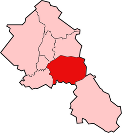 Butterworth shown within the parish of Rochdale | |||||||
| Area | |||||||
| • 1871 | 7,766 acres (31.43 km2) | ||||||
| • 1891 | 7,766 acres (31.43 km2) | ||||||
| Population | |||||||
| • 1841 | 5,648 | ||||||
| • 1891 | 9,352 | ||||||
| History | |||||||
| • Created | Middle Ages | ||||||
| • Abolished | 1894 | ||||||
| Status | Township (1148–1894) & Civil Parish (1866–1894) | ||||||
| • Units | Butterworth Freehold, Butterworth Lordship | ||||||
| |||||||
Butterworth was a township occupying the southeastern part of the parish of Rochdale, in the hundred of Salford, Lancashire, England.[1] It encompassed 12.1 square miles (31 km2) of land in the South Pennines which spanned the settlements of Belfield, Bleaked-gate-cum-Roughbank, Butterworth Hall, Clegg, Haughs, Hollingworth, Kitcliffe, Lowhouse, Milnrow, Newhey, Ogden, Rakewood, Smithy Bridge, Tunshill and Wildhouse. It extended to the borders of Crompton to the south, and to the highest points of Bleakedgate Moor and Clegg Moor, up to the ridge of Blackstone Edge, to the east, where its boundary was the old county boundary between Lancashire and Yorkshire.[2]
Butterworth was probably settled in Saxon times in the Early Middle Ages. Its land was divided into two divisions, the Lordship side with rents or services payable to the lord of the manor and the Freehold side that retained its importance until 1879 as a Registration district for births, deaths and marriages.[3] In 1830, Butterworth was recorded to have 5,554 inhabitants.[4]
YouTube Encyclopedic
-
1/3Views:39 509127 3734 096 043
-
Butterworth, The mainland of Penang - Massive Development in 2022
-
South Africa 1981 archive footage
-
Man Finds Hidden Doorway On His Property ; Goes In And Realizes He’s Made A Huge Mistake..
Transcription
History
Origins
Butterworth probably originates from the Anglo-Saxon settlement of England in the early Middle Ages. Its name is derived from the Old English butere meaning butter and worð meaning an enclosure.[5] Butterworth was one of four divisions of the ancient parish of Rochdale in the Salford Hundred. Its recorded history dates from the mid-12th century. The Order of St John of Jerusalem, the Knights Hospitaller, had extensive land holdings, and whose practice was to mark the boundaries of their lands and buildings where rents were due by a stone or metal cross. In 1851 an old half-timbered house at Butterworth Hall hamlet was destroyed by fire revealing an iron cross at its gable, indicating it was owned by the order until the dissolution of the monasteries in 1536-1539 by Henry VIII. A charter of 1244, mentioned land in Butterworth adjoining land belonging to Sir Baldwin Teutonicas (or de Tyas) who was a knight of the order. A charter of about 1280 transferred rents amounting to twopence in silver and four barbed arrows of iron for lands in Butterworth to the Abbot of Stanlow Abbey.[6] The name of the township was used by Reginal(d) de Boterworth, lord of the manor who was granted land in the township by a charter of 1148. Butterworth Hall was built before 1166. A manuscript from the reign of Edward II recorded the township's name as Buckworth[7]
Governance
The Knights of the Order of St John of Jerusalem held a court leet in Butterworth after 1148. In 1253, in the reign of Henry III, permission was granted for the Knights to erect a gallows "on a bleak hill to the north of Milnrow", now commemorated in the name of a public house at the top of Kiln Lane hill.[8] The manorial courts were replaced by the Duchy Court with a Deputy Bailiff in Rochdale, referenced in relation to actions for trespass in 1567 and for breach of contract in 1608.[9] A courthouse for hearings of petty sessions before justices of the peace was built in 1656 on Dale Street, Milnrow.[10] The manorial division of Butterworth continued into the 19th and early 20th centuries. In 1828,the Lordship side and the Freehold side each had an overseer and a constable. Welfare provisions, derived from the Elizabethan Poor Law of 1601, were replaced by Poor Law Amendment Acts of the 19th century.[11]
Industrialisation and population increases in Milnrow and Newhey were made at the expense of Butterworth. Milnrow Local Board was formed in 1870 and parts of Butterworth including Hollingworth Lake, were transferred to local boards in Littleborough and Wardle. In 1894 Milnrow Local Board was replaced by Milnrow Urban District Council, and the township identity ceased but its name survives in the hamlet Butterworth Hall, its hall, and Butterworth Hall Brook. The area of the former township lies within the Metropolitan Borough of Rochdale in Greater Manchester.
Religion
Before the Reformation, Milnrow was the chapelry in the township which was in the ecclesiastical parish of Rochdale and diocese of Lichfield. In 1400 the Bishop of Lichfield granted a licence to Sir John Byron, an ancestor of the 19th-century poet Lord Byron, to celebrate mass in a chantry chapel at Butterworth Hall. In 1496 a chapel was built on the banks of the River Beal in Milnrow.[12] A Parliamentary Inquisition of 1650 concluded that "Butterworth was fit to be made a parish" on account of its population and the income of its chapel.[13] By the 19th century Milnrow had become the dominant settlement in the township and was created a separate parish by the Rochdale Vicarage Act 1866. A parish church dedicated to St James was built in 1868. In 1876-77 the Church of St Thomas was built in Newhey becoming the second parish in the township acknowledging that Newhey had become the second most important settlement.
References
- ^ "Butterworth CP/Tn". A vision of Britain through time.
- ^ Edward Baines The History of the County Palatine and Duchy of Lancashire, Vol 1 (George Routledge, London) 1868. Baines cites in full, at p489, an Inquisition of 1610 detailing the exact boundaries of Butterworth. See also a brief outline in Clegg's Directory of Rochdale, 1899/1900 ed, Milnrow & Newhey section, p233
- ^ Clegg's Directory above, 1879 ed, entry for James Barnes, p155. The registrar for the Lordship side was then described as Registrar for Milnrow See also 'Townships: Butterworth', A History of the County of Lancaster: Volume 5
- ^ SALFORD HUNDRED ANCESTRY, ANNALS AND HISTORY Edwin Butterworth, below, recorded 5,648 in 1841
- ^ "Butterworth". Nottingham University. Retrieved 1 August 2015.
- ^ Henry Fishwick The History of the Parish of Rochdale in the County of Lancaster (James Clegg, Rochdale & London) 1889 p281. The Abbey is called Stanlawe Abbey in other sources, e.g. Herbert C Collins The Roof of Lancashire (Dent & Sons, London) 1950, esp.pp152-3. The abbot moved to Whalley in 1296. J.J.Bagley A History of Lancashire (Phillimore, London & Chichester) 1976 6th ed.,p28
- ^ Baines, above, p505. Fishwick, above, p337, although Fishwick doubted that the Butterworths ever lived in the hall.
- ^ Baines, above, p506. Harvey Kershaw Beyond the Boundary (Rochdale) 1979 Edwin Butterworth A Statistical Sketch of the County Palatine of Lancaster (Longman & Co, London) 1841, p118 Brian Hindle The Cotton Mills of Crompton, Vol 2 (1800-1860), 2006, p8, describes a summons to the Prior of the Order asking him to show by what right he had erected gallows in the adjoining township of Crompton
- ^ Fishwick, above, pp384-6
- ^ Tim Hignett, Milnrow and Newhey: A Lancashire Legacy (George Kelsall, Littleborough) 1991, p39, where a drawing of the court house by John Collier (Tim Bobbin) is reproduced
- ^ James Butterworth, A History and Description of the Town and Parish of Rochdale (Rochdale, published by subscription) 1828, p128. Clegg's Commercial Directory of Rochdale, 1916 edition, Milnrow section, p306
- ^ Fishwick, above, p338. Hignett, above, p32
- ^ Baines, above, p486
External links
53°37′N 2°06′W / 53.61°N 2.10°W