
Brebes District
Kecamatan Brebes | |
|---|---|
 Sights in Brebes (clockwise from top) : Randusanga Beach, Ciblon Waterboom, Alun alun Brebes, Great Mosque of Brebes, Karangbirahi Stadium | |
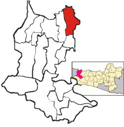 Location Brebes District in Brebes Regency | |
| Coordinates: 6°52′30″S 109°03′10″E / 6.87500°S 109.05278°E | |
| Country | Indonesia |
| Province | Central Java |
| Regency | Brebes |
| Government | |
| • Camat | M. Amrin Alfi Umar, S.IP, M.Si[1] |
| Area | |
| • Total | 92.23 km2 (35.61 sq mi) |
| Population (2020 Census)[2] | |
| • Total | 182,421 |
| • Density | 2,000/km2 (5,100/sq mi) |
| Time zone | UTC+07.00 (WIB) |
| Postal Code | 52211 to 52220, 52251 |
| Area code | 0283 |
Brebes District is a district (Indonesian: Kecamatan) and the capital of Brebes Regency, Central Java, Indonesia. It is bordered by the Java Sea to the north, Tegal City (West Tegal District and Margadana District) and Tegal Regency (Dukuhturi District and Adiwerna District) to the east, Jatibarang District to the south and Wanasari District to the west. It covers 92.23 km2 and had a population of 157,149 at the 2010 Census[3] and 182,421 at the 2020 Census.[4]
YouTube Encyclopedic
-
1/3Views:7 2904 1551 540
-
Blusukan Kota Brebes Jawa Tengah
-
SMA Negeri 2 Brebes mewakili Polres Brebes
-
Pawai HUT RI 72 desa kaligangsa kulon brebes Dengan Kreasi-kreasi Yang Memukau Banget Sip Pokoke,,,
Transcription
History
In early January 1950, DI/TII forces led by Amir Fatah briefly occupied Brebes. Later, they retreated from the town after facing a battle from TNI.[5]
Administrative Villages
Brebes District is divided into 23 administrative villages (5 kelurahan and 18 desa).
Desa
- Banjaranyar
- Kaligangsa Kulon
- Kaligangsa Wetan
- Kalimati
- Kaliwlingi
- Kedunguter
- Krasak
- Lembarawa
- Padasugih
- Pagejugan
- Pemaron
- Pulosari
- Randusanga Kulon
- Randusanga Wetan
- Sigambir
- Tengki
- Terlangu
- Wangandalem
Kelurahan
- Brebes
- Gandasuli
- Limbangan Kulon
- Limbangan Wetan
- Pasar Batang
References
- ^ Ita (3 May 2015). "4.491 Relawan Kader Pendata Mulai Lakukan Pendataan Keluarga" (in Indonesian). Vimanews. Retrieved 12 May 2015.
- ^ Badan Pusat Statistik, Jakarta, 2021.
- ^ Biro Pusat Statistik, Jakarta, 2011.
- ^ Badan Pusat Statistik, Jakarta, 2021.
- ^ Jayusman, Jayusman (2000). Gerakan DI/TII Amir Fatah 1949-1950 suatu pemberontakan kaum santri di daerah Tegal-Brebes (Thesis). Universitas Indonesia. p. 123.
This Central Java location article is a stub. You can help Wikipedia by expanding it. |