
Bratske
Братське | |
|---|---|
 Bratske  Bratske | |
| Coordinates: 47°51′58″N 31°34′24″E / 47.86611°N 31.57333°E | |
| Country | Ukraine |
| Oblast | Mykolaiv Oblast |
| Raion | Voznesensk Raion |
| Population (2022)[1] | |
| • Total | 4,953 |
| Time zone | UTC+2 (EET) |
| • Summer (DST) | UTC+3 (EEST) |
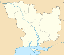
Bratske (Ukrainian: Братське, Russian: Бра́тское) is a rural settlement in Voznesensk Raion in the north of Mykolaiv Oblast, Ukraine. It hosts the administration of Bratske settlement hromada, one of the hromadas of Ukraine.[2] Population: 4,953 (2022 estimate).[1]
Bratske is located on the banks of the Mertvovid, a right tributary of the Southern Bug.
YouTube Encyclopedic
-
1/3Views:3053961 914
-
Gibet - ogovaranje i bratske veze
-
RTV Zigic, BNTV, RTS Satelit: Slava Srpske bratske pomoći u Čikagu
-
Da li su Srbija i Rusija zaista bratske države?
Transcription
History
Bratske was founded by Zaporozhian Cossacks in the 18th century.[3] In the 1860s, it belonged to Yelisavetgradsky Uyezd of Kherson Governorate[4] On 16 April 1920, Kherson Governorate was renamed Nikolayev Governorate, and on 21 October 1922, it was merged into Odessa Governorate. In 1923, uyezds in Ukrainian Soviet Socialist Republic were abolished, and the governorates were divided into okruhas. In 1923, Bratske Raion with the administrative center located in Bratske was established. It belonged to Lyzavethrad Okruha (in 1924 renamed Zinovievsk Okruha).[5] In 1925, the governorates were abolished, and okruhas were directly subordinated to Ukrainian SSR. In 1930, okruhas were abolished, and on 27 February 1932, Odessa Oblast was established, and Bratske Raion was included into Odessa Oblast. In 1944, Bratske Raion was transferred to Mykolaiv Oblast.[6] In 1956, Bratske was granted urban-type settlement status.[7]
On 18 July 2020, Bratske Raion was abolished as part of the administrative reform of Ukraine, which reduced the number of raions of Mykolaiv Oblast to four. The area of Bratske Raion was merged into Voznesensk Raion.[8][9] On 26 January 2024, a new law entered into force which abolished the status of urban-type settlement status, and Bratske became a rural settlement.[10]
Economy
Transportation
The closest railway station, about 25 kilometres (16 mi) northwest of the settlement, is in Liudmilivka, on the railway line connecting Odessa and Pomichna.[7]
References
- ^ a b Чисельність наявного населення України на 1 січня 2022 [Number of Present Population of Ukraine, as of January 1, 2022] (PDF) (in Ukrainian and English). Kyiv: State Statistics Service of Ukraine. Archived (PDF) from the original on 4 July 2022.
- ^ "Братская громада" (in Russian). Портал об'єднаних громад України.
- ^ "Казацкие поселения на Николаевщине" (in Russian). Николаевская область. Электронная историческая энциклопедия. Retrieved 6 March 2016.
- ^ "Городские поселения Российской империи (1708–1913 гг.)" (in Russian). Российская империя. Retrieved 7 March 2016.
- ^ "Обзор политического состояния СССР за август 1929 г. (по данным Объединенного государственного политического управления)" (in Russian). IstMat. Archived from the original on 18 February 2020. Retrieved 7 March 2016.
- ^ "Районы Николаевской области" (in Russian). Николаевская область. Электронная историческая энциклопедия. Retrieved 6 March 2016.
- ^ a b Украинская ССР - Административно-территориальное деление на 1 января 1979 года. Kiev: Ukrainian Soviet Encyclopedia. 1979.
- ^ "Про утворення та ліквідацію районів. Постанова Верховної Ради України № 807-ІХ". Голос України (in Ukrainian). 2020-07-18. Retrieved 2020-10-03.
- ^ "Нові райони: карти + склад" (in Ukrainian). Міністерство розвитку громад та територій України.
- ^ "Что изменится в Украине с 1 января". glavnoe.in.ua (in Russian). 1 January 2024.