
Branson µSA | |
|---|---|
| Branson micropolitan statistical area | |
 Branson µSA, 2020–present | |
 Branson µSA, 2000–2020 | |
| Coordinates: 36°42′N 93°18′W / 36.7°N 93.3°W | |
| Country | United States |
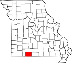
| State | Missouri |
| Counties | Stone, Taney |
| Area | |
| • Total | 1,162 sq mi (3,010 km2) |
| • Land | 1,095 sq mi (2,840 km2) |
| • Water | 67 sq mi (170 km2) |
| Population (2020) | |
| • Total | 56,066 |
| • Density | 70.6/sq mi (27.3/km2) |
| Time zone | UTC-6 (CST) |
| • Summer (DST) | UTC-5 (CDT) |
| Area code | 417 |
The Branson Micropolitan Statistical Area, as defined by the United States Census Bureau, is an area in southwestern Missouri, anchored by the city of Branson, that is coterminous with Taney County.[1] For the 2000 and 2010 censuses, the area was defined to also include Stone County. After the 2012 estimates the Branson Micropolitan area is part of the Springfield Combined Metropolitan area.[2]
As of the 2020 census it had a population of 56,066.[3]
| Census | Pop. | Note | %± |
|---|---|---|---|
| 2000 | 68,361 | — | |
| 2010 | 83,877 | 22.7% | |
| 2020 | 56,066 | −33.2% | |
| *Stone County was removed from the micropolitan area prior to the 2020 census.[1] U.S. Decennial Census | |||
YouTube Encyclopedic
-
1/5Views:3983 50440314 9995 645
-
Omaha, Arkansas ⭐️🌎 AMERICAN CITIES 🌎⭐️
-
Mountain Home, Arkansas ⭐️🌎 AMERICAN CITIES 🌎⭐️
-
Lead Hill, Arkansas ⭐️🌎 AMERICAN CITIES 🌎⭐️
-
Harrison, Arkansas
-
Harrison, Arkansas ⭐️🌎 AMERICAN CITIES 🌎⭐️
Transcription
County
Communities
Places with more than 10,000 inhabitants
- Branson (principal city) Pop: 12,638
Places with 1,000 to 5,000 inhabitants
- Hollister Pop: 4,583
- Forsyth Pop: 2,730
- Merriam Woods Pop: 2,006
- Kissee Mills (census-designated place) Pop: 1,023
Places with less than 1,000 inhabitants
- Rockaway Beach Pop: 829
- Bull Creek Pop: 426
- Saddlebrooke (partial) Pop: 309
- Taneyville Pop: 274
- Kirbyville Pop: 195
Unincorporated places |
|
Demographics
As of the census of 2000, there were 68,361 people, 27,980 households, and 19,894 families residing within the area. The racial makeup was 96.82% White, 0.23% African American, 0.76% Native American, 0.28% Asian, 0.05% Pacific Islander, 0.54% from other races, and 1.33% from two or more races. Hispanic or Latino of any race were 1.84% of the population.
The median income for a household in the area was $31,768, and the median income for a family was $36,801. Males had a median income of $25,828 versus $19,423 for females. The per capita income for the area was $17,652.
See also
References
- ^ a b "Revised Delineations of Metropolitan Statistical Areas, Micropolitan Statistical Areas, and Combined Statistical Areas, and Guidance on Uses of the Delineations of These Areas" (PDF). Office of Management and Budget. March 6, 2020.
- ^ Bureau, US Census. "2012 Economic Census Reference Maps: Missouri". www.census.gov. Retrieved 2019-06-16.
- ^ Bureau, U. S. Census. "U.S. Census website". United States Census Bureau. Retrieved 2023-09-25.