
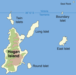
 Map of Hogan Group showing Boundary Islet | |
 Boundary Islet Location of the Boundary Islet in Bass Strait | |
| Geography | |
|---|---|
| Location | Bass Strait |
| Coordinates | 39°11′54″S 147°01′18″E / 39.198355°S 147.021643°E |
| Archipelago | Hogan Group |
| Area | 2 ha (4.9 acres) |
| Length | 141 m (463 ft) |
| Administration | |
Australia | |
| States | |
Boundary Islet, historically known as North East Islet, is a 2-hectare (4.9-acre) islet in the Hogan Island Group of Bass Strait, at a latitude of 39°12′ S, about 56 kilometres (35 mi) east of the southernmost point of mainland Victoria. The islet straddles the maritime border of the Australian states of Victoria and Tasmania, hence the name.[1]
YouTube Encyclopedic
-
1/1Views:6 547
-
Tasmania - Australia
Transcription
Tasmania–Victoria land border
Boundary Islet is divided in the east–west direction at the latitude 39°12′ S, with the northern portion belonging to Victoria and the southern portion belonging to Tasmania. This is Tasmania's only land border, and at 85 metres (279 ft) long, it is the shortest land border between any two Australian states or territories.[2]
This situation is accidental, and arose as a result of an error made by Captain John Black, who surveyed the position of the islet in 1801 and determined its latitude to be slightly farther north than it truly is. The boundary between Victoria and Tasmania was later set along the latitude of 39°12′ S, which was then thought to be completely south of Boundary Islet and not to traverse any land in Bass Strait.[3][4] This would have made the islet completely within the jurisdiction of Victoria. However, when Boundary Islet's correct latitude was later determined it was found to straddle the border. It is for this reason that what was once known as North East Islet (being situated in the north-east of the Hogan Group) came to be known as Boundary Islet.
See also
References
- ^ "State and Territory Borders: Shortest Border". Geoscience Australia. Commonwealth of Australia. 11 September 2007. Archived from the original on 22 August 2008. Retrieved 18 September 2022.
A little known fact is that there is a land border between Tasmania and Victoria. Straddling the declared parallel line of latitude of 39° 12' S separating the two states is Boundary Islet.
- ^ Jacobs, Frank (24 April 2012). "One Island, Two Countries". The New York Times. Retrieved 18 September 2022.
- ^ Moore, Garry (April 2014). "The boundary between Tasmania and Victoria: Uncertainties and their possible resolution" (PDF). Traverse (294). The Institute of Surveyors Victoria: 5–7. Archived from the original (PDF) on 16 August 2016. Retrieved 10 April 2015.
- ^ Taylor, Greg; Economou, Nicholas (2006). The Constitution of Victoria. Federation Press. pp. 17–. ISBN 978-1-86287-612-5.
| Near East Gippsland | |
|---|---|
| Near Corner Inlet | |
| Near Wilsons Promontory | |
| In Western Port |
|
| In Port Phillip | |
| Near Portland Bay | |
| In rivers | |