
| Bororen Queensland | |||||||||||||||
|---|---|---|---|---|---|---|---|---|---|---|---|---|---|---|---|
 Local store and post office agency on the Bruce Highway | |||||||||||||||
 Bororen | |||||||||||||||
| Coordinates | 24°14′40″S 151°29′43″E / 24.2444°S 151.4952°E | ||||||||||||||
| Population | 399 (SAL 2021)[1] | ||||||||||||||
| Postcode(s) | 4678 | ||||||||||||||
| Area | 330.9 km2 (127.8 sq mi) | ||||||||||||||
| Time zone | AEST (UTC+10:00) | ||||||||||||||
| LGA(s) | Gladstone Region | ||||||||||||||
| State electorate(s) | Burnett | ||||||||||||||
| Federal division(s) | Flynn | ||||||||||||||
| |||||||||||||||
Bororen is a rural town and locality in the Gladstone Region, Queensland, Australia.[2][3] In the 2016 census, Bororen had a population of 398 people.[4]
Geography
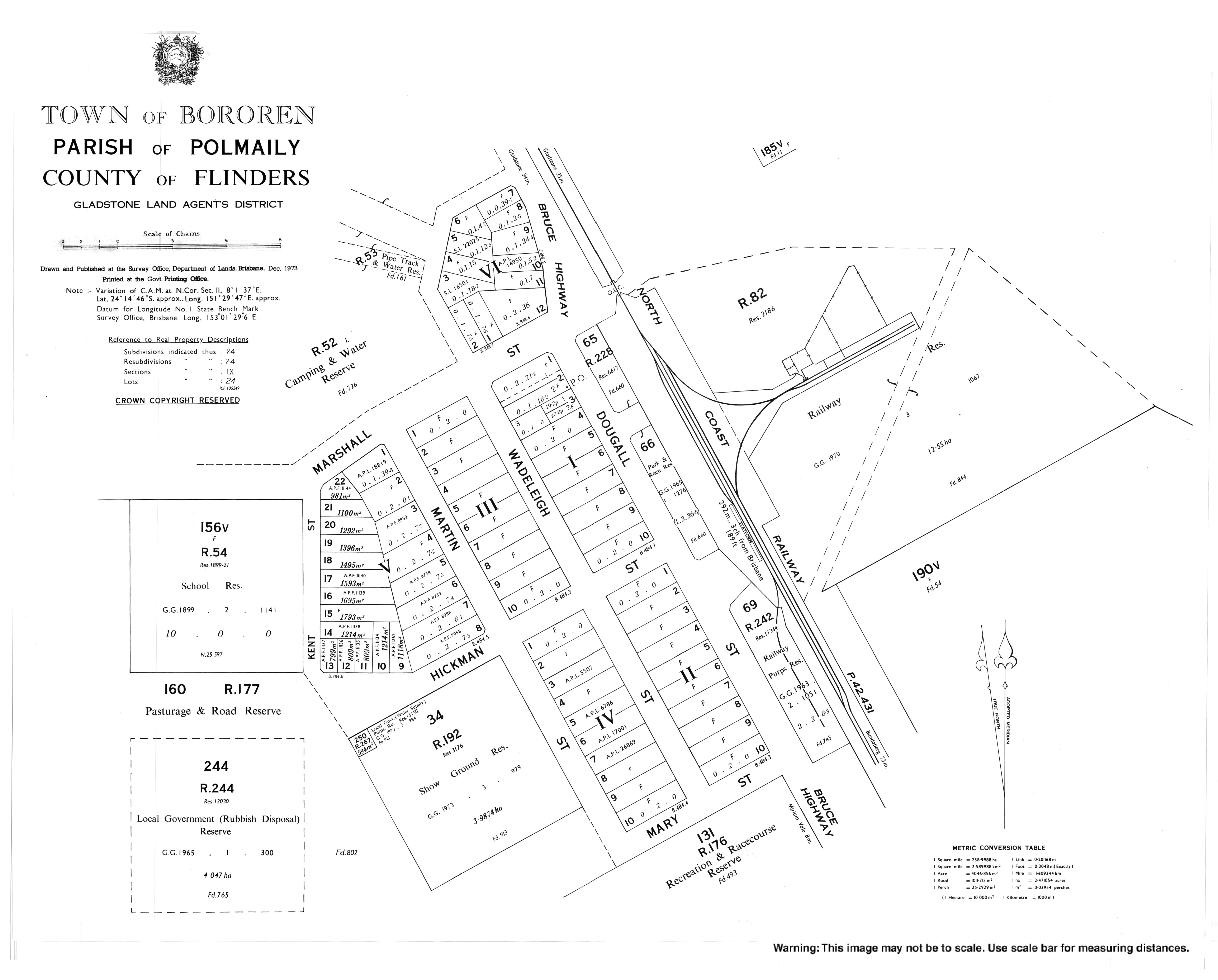
The town is located in the centre of the locality. The Bruce Highway enters from the south-east (Miriam Vale), passes through the town, and exits to the north (Foreshores).[5]
The North Coast railway line also enters from the south-east (Miriam Vale), passes through the town which is served by the Bororen railway station (24°14′34″S 151°29′48″E / 24.2429°S 151.4967°E),[6] and exits to the north (Foreshores).[5]
Boondilla is a neighbourhood in the north-west of the locality (24°13′00″S 151°26′00″E / 24.2166°S 151.4333°E).[7]
History

The name Bororen means old man kangaroo.[8]
Bororen Post Office opened 2 June 1898; a receiving office had been open since about October 1897.[9]
Bororen Provisional School opened on 22 January 1900. It became a State School in 1909.[10][11][8]
Turkey Road State School opened on 1921 and closed on 24 May 1931.[12] It was on Bates Road (approx 24°13′05″S 151°31′50″E / 24.2181°S 151.5305°E).[13]
Bororen Anglican Church opened on 2 July 1931. It closed in 2015 and the building was later removed from the site. It was at 17 Dougall Street (24°14′41″S 151°29′47″E / 24.244685°S 151.4964°E).[14][15]
Bororen Presbyterian Church opened on Sunday 21 October 1923.[16] It has been demolished.[17]
In about 1995, a war memorial was unveiled on the Bruce Highway, Bororen (24°14′35″S 151°29′46″E / 24.243016°S 151.496029°E). It commemorates those servicemen and women who served in World War I and World War II.[18]
In the 2011 census, Bororen had a population of 417 people.[19]
In the 2016 census, Bororen had a population of 398 people.[4]
Education

Bororen State School is a government primary (Prep-6) school for boys and girls at 1 Kent Street (24°14′39″S 151°29′31″E / 24.2443°S 151.4919°E).[20][21] In 2017, the school had an enrolment of 37 students with 4 teachers (3 full-time equivalent) and 5 non-teaching staff (2 full-time equivalent).[22] In 2018, the school had an enrolment of 31 students with 4 teachers (3 full-time equivalent) and 7 non-teaching staff (3 full-time equivalent).[23]
There are no secondary schools in Bororen. The nearest government secondary schools are Miriam Vale State School (to Year 10) in neighbouring Miriam Vale to the south-east and Tannum Sands State High School (to Year 12) in Tannum Sands to the north.[5]
References
- ^ Australian Bureau of Statistics (28 June 2022). "Bororen (suburb and locality)". Australian Census 2021 QuickStats. Retrieved 28 June 2022.
- ^ "Bororen – town in Gladstone Region (entry 3898)". Queensland Place Names. Queensland Government. Retrieved 28 September 2017.
- ^ "Bororen – locality in Gladstone Region (entry 49131)". Queensland Place Names. Queensland Government. Retrieved 28 September 2017.
- ^ a b Australian Bureau of Statistics (27 June 2017). "Bororen (SSC)". 2016 Census QuickStats. Retrieved 20 October 2018.
- ^ a b c "Queensland Globe". State of Queensland. Retrieved 27 February 2023.
- ^ "Railway stations and sidings - Queensland". Queensland Open Data. Queensland Government. 2 October 2020. Archived from the original on 5 October 2020. Retrieved 5 October 2020.
- ^ "Boondilla – locality unbounded in Gladstone Regional (entry 3751)". Queensland Place Names. Queensland Government. Retrieved 27 February 2023.
- ^ a b "The History of Bororen State School". Bororen State School. 5 July 2019. Retrieved 27 February 2023.
- ^ Premier Postal History. "Post Office List". Premier Postal Auctions. Retrieved 2 July 2014.
- ^ "Opening and closing dates of Queensland Schools". Queensland Government. Retrieved 2 July 2014.
- ^ "Agency ID 4996, Bororen State School". Queensland State Archives. Retrieved 3 July 2014.
- ^ Queensland Family History Society (2010), Queensland schools past and present (Version 1.01 ed.), Queensland Family History Society, ISBN 978-1-921171-26-0
- ^ "County of Flinders" (Map). Queensland Government. 1922. Retrieved 27 February 2023.
- ^ Blake, Thom. "Bororen Anglican Church". Queensland religious places database. Retrieved 27 February 2023.
- ^ Spelitis, Helen (28 November 2015). "End of an era with Anglican church up for sale for $65,000". Gladstone Observer. Retrieved 27 February 2023.
- ^ "Bororen Presbyterian Church". The Bundaberg Mail. Vol. 53, no. 8516. Queensland, Australia. 27 October 1923. p. 4. Retrieved 27 February 2023 – via National Library of Australia.
- ^ Blake, Thom. "Bororen Presbyterian Church". Queensland religious places database. Retrieved 22 September 2022.
- ^ "Bororen War Memorial". Monument Australia. Retrieved 3 July 2014.
- ^ Australian Bureau of Statistics (31 October 2012). "Bororen (SSC)". 2011 Census QuickStats. Retrieved 2 July 2014.
- ^ "State and non-state school details". Queensland Government. 9 July 2018. Archived from the original on 21 November 2018. Retrieved 21 November 2018.
- ^ "Bororen State School". Bororen State School. 24 August 2022. Retrieved 27 February 2023.
- ^ "ACARA School Profile 2017". Archived from the original on 22 November 2018. Retrieved 22 November 2018.
- ^ "ACARA School Profile 2018". Australian Curriculum, Assessment and Reporting Authority. Retrieved 28 January 2020.
Further reading
- Bororen State School (2000), Bororen State School centenary 1900-2000 : including Bororen, Iveragh, Boondilla and Turkey Road Schools, The School
External links
![]() Media related to Bororen at Wikimedia Commons
Media related to Bororen at Wikimedia Commons
- "Miriam Vale and Miriam Vale Shire". Queensland Places. Centre for the Government of Queensland, University of Queensland. —includes Bororen
- "Town map of Bororen". Queensland Government. 1973.