
Bobonaro | |
|---|---|
| |
 Marobo Hot Springs | |
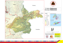 Official map | |
 Bobonaro | |
| Coordinates: 9°2′S 125°20′E / 9.033°S 125.333°E | |
| Country | |
| Municipality | Bobonaro |
| Seat | Bobonaro |
| Sucos |
|
| Area | |
| • Total | 212.5 km2 (82.0 sq mi) |
| Population (2015 census) | |
| • Total | 24,719 |
| • Density | 120/km2 (300/sq mi) |
| Households (2015 census) | |
| • Total | 4,467 |
| Time zone | UTC+09:00 (TLT) |
Bobonaro, officially Bobonaro Administrative Post (Portuguese: Posto Administrativo de Bobonaro, Tetum: Postu administrativu Bobonaru), is an administrative post (and was formerly a subdistrict) in Bobonaro municipality, East Timor.[1][2] Its seat or administrative centre is Bobonaro,[3][2] and its population at the 2010 census was 23,108.[4]
YouTube Encyclopedic
-
1/1Views:1 625
-
Climbing Matebian 2316 m. (Matebean Mane), Baguia - second highest mountain in Timor Leste.
Transcription
References
- ^ "Subdistricts of Timor-Leste". www.statoids.com. 4 May 2010. Retrieved 21 September 2022.
- ^ a b "Diploma Ministerial n.o 24/2014 de 24 de Julho Orgânica dos Postos Administrativos Preâmbulo" [Ministerial Diploma No. 24/2014 of 24 July Organic of Administrative Posts Preamble]. Jornal da República (in Portuguese). Government of East Timor. 24 July 2014. Archived from the original on 4 March 2016. Retrieved 21 September 2022.
- ^ "UNMIT Geographic Maps: Bobonaro District - August 2008" (PDF). Archived from the original (PDF) on 8 November 2012. Retrieved 6 April 2015.
- ^ "Preliminary Result of Census 2010 English" (PDF). Direcção Nacional de Estatística. Archived from the original (PDF) on 6 September 2014.
External links
![]() Media related to Bobonaro Administrative Post at Wikimedia Commons
Media related to Bobonaro Administrative Post at Wikimedia Commons
- Bobonaro Administrative Post – information page on Ministry of State Administration site (in Portuguese)
This East Timor location article is a stub. You can help Wikipedia by expanding it. |