
Berkovići
Берковићи | |
|---|---|
Village and municipality | |
 Berkovići | |
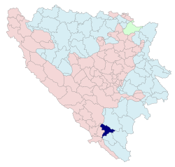 Location of Berkovići within Bosnia and Herzegovina | |
 | |
| Coordinates: 43°05′41″N 18°09′52″E / 43.09472°N 18.16444°E | |
| Country | |
| Entity | |
| Geographical region | Herzegovina |
| Government | |
| • Municipal mayor | Nenad Abramović (SDS) |
| Area | |
| • Total | 249.69 km2 (96.41 sq mi) |
| Population (2013 census) | |
| • Total | 2,114 |
| • Density | 8.5/km2 (22/sq mi) |
| Time zone | UTC+1 (CET) |
| • Summer (DST) | UTC+2 (CEST) |
| Area code | 59 |
| Website | www |
Berkovići (Serbian Cyrillic: Берковићи) is a village and municipality in Republika Srpska, Bosnia and Herzegovina. As of 2013, it has a population of 2,114 inhabitants.
YouTube Encyclopedic
-
1/2Views:8361 208
-
Berkovići-radio Berkovići.flv
-
Berkovići-asfaltiranje suzine.flv
Transcription
Geography
The municipality is located in the westernmost part of East Herzegovina.[1]
History
The municipality was created in 1995, after the Bosnian War, out of the Republika Srpska-controlled portions of the pre-war municipality of Stolac (now in Federation of B&H).[2] The village was struck by a big earthquake on April 22, 2022 with a magnitude of 5.7 on the Richter scale.[3]
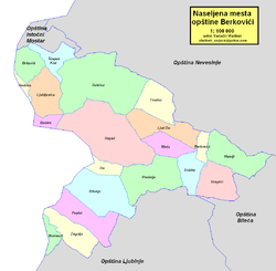
Settlements
Aside from the town of Berkovići, the municipality includes the following settlements:
Berkovići also contains parts of the following settlements:
- Barane
- Burmazi
- Do
- Hodovo
- Hrgud
Demographics
Population
| Population of settlements – Berkovići municipality | ||||||||
|---|---|---|---|---|---|---|---|---|
| Settlement | 1938. | 1953. | 1961. | 1971. | 1981. | 1991. | 2013. | |
| Total | 2,573 | 3,166 | 2,114 | |||||
| 1 | Berkovići | 747 | 749 | 651 | 159 | 230 | ||
| 2 | Hatelji | 468 | 409 | |||||
| 3 | Ljuti Do | 316 | 233 | |||||
| 4 | Meča | 88 | 300 | |||||
Ethnic composition


| Ethnic composition – Berkovići town | ||||
|---|---|---|---|---|
| 2013 | 1991. | 1981. | 1971. | |
| Total | 240 (100,0%) | 159 (100,0%) | 651 (100,0%) | 749 (100,0%) |
| Serbs | 238 (99,17%) | 147 (97,484%) | 611 (93,856%) | 744 (100,0%) |
| Croats | 2 (0,83%) | 1 (0,154%) | 1 (0,134%) | |
| Bosniaks | 4 (2,516%) | 4 (0,614%) | ||
| Yugoslavs | 33 (5,069%) | |||
| Other | 2 (0,307%) | 2 (0,267%) | ||
| Montenegrins | 1 (0,134%) | |||
| Macedonians | 1 (0,134%) | |||
| Ethnic composition – Berkovići municipality | |
|---|---|
| 2013 | |
| Total | 2,114 (100,0%) |
| Serbs | 1,942 (91,86%) |
| Bosniaks | 159 (7,52%) |
| Croats | 11 (0,52%) |
| Others | 2 (0,09%) |
Economy
The municipality is underdeveloped and much of the economic activity is agricultural.[citation needed]
See also
References
- ^ Lojović, Milimir; Gnjato, Obren (2016). "The old village in Eastern Herzegovina and possibilities of their revitalization". Demografija (13): 353–373. ISSN 1820-4244. 1820-42441613353L.
- ^ "O Berkovićima". Opština Berkovici (in Serbian). Retrieved 2021-01-18.
- ^ Service, s Balkan (2022-04-23). "Bosnian Quake Victim Died After Hillside Collapsed On Home". RadioFreeEurope/RadioLiberty. Retrieved 2023-09-27.
