
Beaverville, Illinois | |
|---|---|
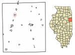 Location of Beaverville in Iroquois County, Illinois | |
 Beaverville Beaverville's location in Iroquois County | |
| Coordinates: 40°57′16″N 87°39′16″W / 40.95444°N 87.65444°W | |
| Country | |
| State | |
| County | Iroquois |
| Township | Beaverville |
| Area | |
| • Total | 0.28 sq mi (0.72 km2) |
| • Land | 0.28 sq mi (0.71 km2) |
| • Water | 0.00 sq mi (0.01 km2) |
| Elevation | 676 ft (206 m) |
| Population (2020) | |
| • Total | 306 |
| • Density | 1,112.73/sq mi (429.33/km2) |
| ZIP code | 60912 |
| Area code | 815 |
| FIPS code | 17-04507 |
Beaverville (formerly St. Marie) is a village in Beaverville Township, Iroquois County, Illinois, United States. The population was 362 at the 2010 census.[2]
YouTube Encyclopedic
-
1/3Views:1 6481 809690
-
2015 Soybean Harvest near Gilman Illinois
-
Versatile 260 Tractor pulling a Disk in Illinois - Spring 2016
-
Versatile 310 pulling a McFarlane VT Tool in Illinois
Transcription
History
In 1851, 32 families from the area of Montreal, Canada, mostly newlywed or single, came up the St. Lawrence River in search of farmland on the prairie. They traveled across the Great Lakes and stopped at Fort Dearborn (Chicago). Then they pushed south through the swamps and frontier until they reached the area that is now Beaverville. The settlement, named "St. Marie," was led by Francis Besse, who became a general merchant. The group consisted of families with names such as Fortin, Dionne, Boudreau, Benoit, Nourie, Lafond, Lemna, and at least six Arseneau families. They settled here because of the good land and the many creeks.
In 1905, the village name was changed to "Beaverville", when the village founders realized that there was another town in Illinois named St. Mary.[3] The new name was inspired by the profusion of beavers in the area in the early 19th century, when Beaver Lake right across the border in Indiana still existed.
The Cathedral of the Cornfields

Beaverville is home to St. Mary's Catholic Church, known as the "Prairie Cathedral" or the "Cathedral of the Cornfields". Built in 1909, the structure is recorded in the National Register of Historic Places and is large enough that its red, clay-tile roof can be seen from several miles away.
Geography
Beaverville is located in northeastern Iroquois County at 40°57′16″N 87°39′14″W / 40.95444°N 87.65389°W (40.954567, -87.654016).[4] It is 16 miles (26 km) northeast of Watseka, the county seat; 20 miles (32 km) southeast of Kankakee; and 7 miles (11 km) west of the Indiana border. Under Quick Facts, above, in the map of Iroquois County, Beaverville is the northeastern-most town that is colored red, not the northwestern town that (for some reason) is encircled in red.
According to the 2010 census, Beaverville has a total area of 0.265 square miles (0.69 km2), of which 0.26 square miles (0.67 km2) (or 98.11%) is land and 0.005 square miles (0.01 km2) (or 1.89%) is water.[5]
Demographics
| Census | Pop. | Note | %± |
|---|---|---|---|
| 1900 | 395 | — | |
| 1910 | 401 | 1.5% | |
| 1920 | 402 | 0.2% | |
| 1930 | 348 | −13.4% | |
| 1940 | 425 | 22.1% | |
| 1950 | 383 | −9.9% | |
| 1960 | 430 | 12.3% | |
| 1970 | 442 | 2.8% | |
| 1980 | 377 | −14.7% | |
| 1990 | 278 | −26.3% | |
| 2000 | 391 | 40.6% | |
| 2010 | 362 | −7.4% | |
| 2020 | 306 | −15.5% | |
| U.S. Decennial Census[6] | |||
As of the census[7] of 2000, there were 391 people, 151 households, and 104 families residing in the village. The population density was 1,491.4 inhabitants per square mile (575.8/km2). There were 162 housing units at an average density of 617.9 per square mile (238.6/km2). The racial makeup of the village was 99.23% White, 0.26% Asian, 0.26% from other races, and 0.26% from two or more races. Hispanic or Latino of any race were 0.51% of the population.
There were 151 households, out of which 29.8% had children under the age of 18 living with them, 51.7% were married couples living together, 10.6% had a female householder with no husband present, and 31.1% were non-families. 25.2% of all households were made up of individuals, and 17.9% had someone living alone who was 65 years of age or older. The average household size was 2.59 and the average family size was 3.05.
In the village, the population was spread out, with 27.6% under the age of 18, 8.2% from 18 to 24, 23.5% from 25 to 44, 21.5% from 45 to 64, and 19.2% who were 65 years of age or older. The median age was 38 years. For every 100 females, there were 96.5 males. For every 100 females age 18 and over, there were 87.4 males.
The median income for a household in the village was $30,833, and the median income for a family was $34,821. Males had a median income of $31,667 versus $19,792 for females. The per capita income for the village was $13,707. About 6.3% of families and 9.7% of the population were below the poverty line, including 7.8% of those under age 18 and 14.5% of those age 65 or over.
References
- ^ "2020 U.S. Gazetteer Files". United States Census Bureau. Retrieved March 15, 2022.
- ^ "Geographic Identifiers: 2010 Census Summary File 1 (G001): Beaverville village, Illinois". American Factfinder. U.S. Census Bureau. Archived from the original on February 13, 2020. Retrieved March 27, 2018.
- ^ "Page Title". Archived from the original on May 11, 2008. Retrieved October 31, 2009.
- ^ "US Gazetteer files: 2010, 2000, and 1990". United States Census Bureau. February 12, 2011. Retrieved April 23, 2011.
- ^ "G001 - Geographic Identifiers - 2010 Census Summary File 1". United States Census Bureau. Archived from the original on February 13, 2020. Retrieved August 2, 2015.
- ^ "Census of Population and Housing". Census.gov. Retrieved June 4, 2015.
- ^ "U.S. Census website". United States Census Bureau. Retrieved January 31, 2008.
Municipalities and communities of Iroquois County, Illinois, United States | ||
|---|---|---|
| Cities |  | |
| Villages | ||
| Townships | ||
| Unincorporated communities | ||
| Footnotes | ‡This populated place also has portions in an adjacent county or counties | |