
| Bass | |
|---|---|
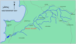 Map of Bass River, Victoria | |
| Etymology | In honour of George Bass |
| Native name |
|
| Location | |
| Country | Australia |
| State | Victoria |
| Region | South East Coastal Plain (IBRA), West Gippsland |
| Local government area | Bass Coast Shire |
| Physical characteristics | |
| Source | Strzelecki Ranges |
| • location | below Woodleigh |
| • coordinates | 38°22′27″S 145°39′29″E / 38.37417°S 145.65806°E |
| • elevation | 60 m (200 ft) |
| Mouth | Western Port |
• location | west of Bass |
• coordinates | 38°29′46″S 145°25′54″E / 38.49611°S 145.43167°E |
• elevation | 0 m (0 ft) |
| Length | 59 km (37 mi) |
| Discharge | |
| • location | mouth |
| Basin features | |
| River system | Western Port catchment |
| Tributaries | |
| • left | Wattle Creek |
| [3] | |

The Bass River, a perennial river of the Western Port catchment, is located in the West Gippsland region of the Australian state of Victoria.
YouTube Encyclopedic
-
1/1Views:2 860
-
bass river State forest
Transcription
Location and features
The Bass River rises below the locale of Woodleigh, west of the South Gippsland Highway, with its headwaters drawn from the Strzelecki Ranges, north of the town of Korumburra. The river flows generally south by west, joined by one minor tributary, before reaching its river mouth and emptying into the Western Port, west of the town of Bass within the Bass Coast Shire. The river descends 60 metres (200 ft) over its combined 59 kilometres (37 mi) course.[3]
The river is traversed by the Bass Highway near the town of Bass.[3]
Etymology
In the Aboriginal Boonwurrung language the river is given two names, Weandon yallock, with yallock meaning "river" or creek",[1] and Tullungurn, with no defined meeting.[2]
The river is now named in honour of George Bass, who came to the river and surrounding area in January 1798 on his "whaleboat" expedition of the southeast coast of Australia.[2]
See also
References
- ^ a b "Bass River: 10130: Traditional Name: Weandon yallock". Vicnames. Government of Victoria. 12 August 2011. Archived from the original on 1 March 2014. Retrieved 25 February 2014.
- ^ a b c "Bass River: 10130: Traditional Name: Tullungurn". Vicnames. Government of Victoria. 12 August 2011. Archived from the original on 1 March 2014. Retrieved 25 February 2014.
- ^ a b c "Map of Bass River, VIC". Bonzle Digital Atlas of Australia. Retrieved 25 February 2014.
External links
- "Home page". Port Phillip & Westernport Catchment Management Authority. website
- Regional Catchment Strategy (PDF). Port Phillip & Westernport Catchment Management Authority. 2004. pp. 43, 90. ISBN 0-9750709-9-1.
Waterways of the Melbourne Water catchment, Victoria, Australia | |
|---|---|
| Rivers |
|
| Creeks |
|
| Lakes |
|
| Drains | Bunyip Main Drain
Wylies Drain |
| Other | |
This article about a location in Gippsland (region) is a stub. You can help Wikipedia by expanding it. |