
| Broghil | |
|---|---|
| بروغل (Urdu) | |
 Mountain passes of Afghanistan | |
| Elevation | 3,798 metres (12,461 ft) |
| Location | Pakistan–Afghanistan border |
| Range | Hindu Kush |
| Coordinates | 36°53′1″N 73°21′1″E / 36.88361°N 73.35028°E |
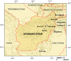
 Broghil Location of the Broghil Pass within the greater Karakoram region 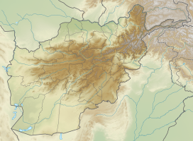 Broghil Broghil (Afghanistan)  Broghil Broghil (Gilgit Baltistan)  Broghil Broghil (Pakistan)  Broghil Broghil (Pamir) | |
 | |
Broghil, also spelled Broghol, elevation 3,798 metres (12,461 ft), is a high mountain pass along the Durand Line border that crosses the Hindu Kush mountain range and connects Wakhan District of Badakhshan Province, Afghanistan with Chitral District of Khyber Pakhtunkhwa, Pakistan.
History
Broghil is a relatively low pass. It was closed for about three months each winter because of snow, but for much of the rest of the year it was passable even for cart traffic.
It is one of the four major mountain passes entering Chitral District; the others are the Dorah Pass from Badakshan Province of Afghanistan, Shandur Top from Gilgit, and Lowari Top from Upper Dir District.
The area of Broghil is inhabited by Wakhi and Kyrgyz people.
European migration
According to the National Geographic Genographic Project, Broghol Pass appears to be the route used by the ancestors of all modern Western Europeans to reach Europe. Modern Europeans carrying the M45 genetic marker crossed Broghol and then turned west; M45 further mutated to become M173 and then M343, which is carried by 70% of the population of England.[1]
In popular culture
- The 1985 comedy movie Spies Like Us depicts Dan Aykroyd crossing the Broghol Pass on a mountain yak.
References
- ^ "Atlas of the Human Journey - the Genographic Project". www9.nationalgeographic.com. Archived from the original on 26 March 2006. Retrieved 22 February 2022.
External links
Further reading
- The Gilgit Game by John Keay (1985) ISBN 0-19-577466-3
- The Kafirs of the Hindukush (1896) Sir George Scott Robertson
- Khowar English Dictionary ISBN 0-923891-15-3
| On the border | |||||
|---|---|---|---|---|---|
| In the interior | |||||