
 | |
 | |
| Geography | |
|---|---|
| Location | Arctic Ocean |
| Coordinates | 78°25′N 21°27′E / 78.417°N 21.450°E |
| Archipelago | Svalbard |
| Area | 1,288 km2 (497 sq mi) 558 km2 (215 sq mi) glaciated. |
| Coastline | 205 km (127.4 mi) |
| Highest elevation | 666 m (2185 ft) |
| Highest point | Solveigdomen |
| Administration | |
Norway | |
| Demographics | |
| Population | 0 |
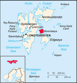
Barentsøya, anglicized as Barents Island, is an Arctic island in the Svalbard archipelago of Norway, lying between Edgeøya and Spitsbergen. To the north, in the sound between Barentsøya and Spitsbergen, lies the island of Kükenthaløya. To the south, the sound separating Barents Island from Edgeøya is Freemansundet.
Barentsøya has no permanent human inhabitants. It is part of the Søraust-Svalbard Nature Reserve[1] and forms a habitat for several species, including polar bears and kittiwakes.[2]
YouTube Encyclopedic
-
1/1Views:498
-
The Svalbard Global Seed Vault *Interesting History*
Transcription
History
The island was named after Dutch explorer Willem Barents who, despite discovering Svalbard, never sighted Barentsøya itself. The name "Barents Land" was only given after an 1865 Swedish expedition. Previously, Dutch whaling captains had referred to it on maps as Zuyd Ooster Land ("Southeastern Land") as early as 1710.[1]
In 1936, Norway built four cabins on the island to formally establish control.[1]
Geography

Barentsøya has an approximately square shape, with maximum lengths and widths of about fifty kilometers,[3] and an area of 1,288 km2 (497 sq mi). A significant part of the island, more than 500 km2 (190 sq mi), is glaciated. The ice cap of Barentsjøkulen covers a large part of the island, with the largest offspring Besselsbreen (north), Duckwitzbreen (west), Freemanbreen (south), and Hübnerbreen (southeast).[4][5][6][7][8] Barentsjøkulen has the two large ice domes of Peer Gyntslottet and Solveigdomen.[9][10] The mountain of Schweinfurthberget is a nunatak of Barentsjøkulen.[11] It has a height of 590 m.a.s.l., is the highest mountain of Barentsøya, and is named after German scientist Georg August Schweinfurth.[12]
At the northern side of Barentsøya is the ice-free peninsula of Frankenhalvøya, between Ginevra Bay at the western side and Dorstbukta to the east.[13][14] Grimheia is an ice-free mountainous area extending over a length of about thirteen kilometers at the northern part of the island.[15] The westernmost point of the island is the headland of Mistakodden.[16] At the southern part of Barentsøya are the mountains of Krefftberget and Høgrinden, while Jeppeberget is located to the southeast.[17][18][19] The largest lakes of the island are Veslemjøsa in Heimarka, and Dalskilvatnet between the valleys of Sjodalen and Grimdalen.[20][21]

Around 43 percent of the island's 1,288 square kilometres (497 sq mi) area is glaciated, and much of the surface rock has been eroded over millions of years by glaciation.[22]
See also
References
- ^ a b c Susan Barr. "Barentsøya". Store norske leksikon. Retrieved November 1, 2016.
- ^ C. Michael Hogan, 2008
- ^ "Barentsøya (Svalbard)". Norwegian Polar Institute. Retrieved 12 February 2015.
- ^ "Barentsjøkulen (Svalbard)". Norwegian Polar Institute. Retrieved 12 February 2015.
- ^ "Besselsbreen (Svalbard)". Norwegian Polar Institute. Retrieved 12 February 2015.
- ^ "Duckwitzbreen (Svalbard)". Norwegian Polar Institute. Retrieved 12 February 2015.
- ^ "Freemanbreen (Svalbard)". Norwegian Polar Institute. Retrieved 12 February 2015.
- ^ "Hübnerbreen (Svalbard)". Norwegian Polar Institute. Retrieved 12 February 2015.
- ^ "Peer Gyntslottet (Svalbard)". Norwegian Polar Institute. Retrieved 12 February 2015.
- ^ "Solveigdomen (Svalbard)". Norwegian Polar Institute. Retrieved 12 February 2015.
- ^ "Schweinfurthberget (Svalbard)". Norwegian Polar Institute. Retrieved 12 February 2015.
- ^ Arctic Pilot: Sailing directions Svalbard–Jan Mayen. Vol. 7. Stavanger: The Norwegian Hydrographic Service and The Norwegian Polar Institute. 1988. p. 360. ISBN 82-90653-06-9.
- ^ "Frankenhalvøya (Svalbard)". Norwegian Polar Institute. Retrieved 12 February 2015.
- ^ "Dorstbukta (Svalbard)". Norwegian Polar Institute. Retrieved 12 February 2015.
- ^ "Grimheia (Svalbard)". Norwegian Polar Institute. Retrieved 12 February 2015.
- ^ "Mistakodden (Svalbard)". Norwegian Polar Institute. Retrieved 12 February 2015.
- ^ "Krefftberget (Svalbard)". Norwegian Polar Institute. Retrieved 12 February 2015.
- ^ "Høgrinden (Svalbard)". Norwegian Polar Institute. Retrieved 12 February 2015.
- ^ "Jeppeberget (Svalbard)". Norwegian Polar Institute. Retrieved 12 February 2015.
- ^ "Veslemjøsa (Svalbard)". Norwegian Polar Institute. Retrieved 12 February 2015.
- ^ "Dalskilvatnet (Svalbard)". Norwegian Polar Institute. Retrieved 12 February 2015.
- ^ Svalbard Images
Line notes
- C. Michael Hogan (2008) Polar Bear: Ursus maritimus, globalTwitcher.com, ed. Nicklas Stromberg
External links
- Svalbard Images: Barentsøya Archived 2004-12-07 at the Wayback Machine (URL accessed 26 December 2008)