
Bangka Regency
Kabupaten Bangka | |
|---|---|
 Coat of arms | |
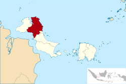 Location within Bangka Belitung Islands | |
| Coordinates: 1°54′S 105°53′E / 1.900°S 105.883°E | |
| Country | Indonesia |
| Province | Bangka Belitung Islands |
| Regency seat | Sungailiat |
| Government | |
| • Regent | Mulkan |
| • Vice Regent | Syahbudin |
| Area | |
| • Total | 3,016.85 km2 (1,164.81 sq mi) |
| Population (mid 2022 estimate)[1] | |
| • Total | 334,344 |
| • Density | 110/km2 (290/sq mi) |
| Time zone | UTC+7 (IWST) |
| Area code | (+62) 717 |
| Website | bangka.go.id |


Bangka Regency is a regency (kabupaten) of Bangka Belitung Islands, Indonesia. It covers an area of 3,016.85 km2 in the northeast of Bangka Island, and had a population of 277,204 at the 2010 Census[2] rising to 326,265 at the 2020 Census;[3] the official estimate as at mid 2022 was 334,344 - comprising 172,248 males and 162,096 females.[1] The coastal town of Sungailiat is its regency seat.
YouTube Encyclopedic
-
1/3Views:1 0853133 914
-
Road to Muntok from Pangkal Pinang, Bangka - Indonesia
-
Toboali City On Fire 2017 Day One
-
Pelabuhan Tanjung Kalian Muntok Bangka Barat - Phantom 3 advanced
Transcription
Administrative Districts
The Regency as at 2022 was divided into eight districts (kecamatan), tabulated below with their areas and their populations at the 2010 Census[2] and the 2020 Census,[3] together with the official estimates as at mid 2022.[1] The table also includes the location of the district administrative centres, the number of administrative villages (totaling 62 rural desa and 19 urban kelurahan) and the number of offshore islands in each district, and its postal codes.
However, a further three districts have recently been established - those of Karang Lintang, Maras Makmur and Simpang Tiga, although data concerning these have not yet been published.
| Kode Wilayah |
Name of District (kecamatan) |
Area in km2 |
Pop'n Census 2010 |
Pop'n Census 2020 |
Pop'n Estimate mid 2022 |
Admin centre |
No. of villages |
No. of islands |
Post codes |
|---|---|---|---|---|---|---|---|---|---|
| 19.01.04 | Mendo Barat | 685.64 | 42,290 | 51,133 | 52,399 | Petaling Banjar | 15 | 8 | 33173 |
| 19.01.03 | Merawang | 215.89 | 26,200 | 30,596 | 31,354 | Batu Rusa | 10 | 1 | 33172 |
| 19.01.08 | Puding Besar | 272.10 | 16,385 | 19,419 | 19,900 | Puding Besar | 7 | - | 33171 |
| 19.01.01 | Sungai Liat | 147.05 | 82,635 | 92,883 | 95,183 | Sri Menanti | 13 | 7 | 33211 - 33215 |
| 19.01.05 | Pemali | 140.46 | 24,985 | 34,705 | 35,564 | Air Duren | 5 | - | 33251 & 33255. |
| 19.01.06 | Bakam | 426.26 | 16,667 | 19,039 | 19,510 | Bakam | 9 | - | 33252 |
| 19.01.02 | Belinyu | 503.54 | 44,401 | 50,200 | 51,443 | Kuto Oanji | 12 | 19 | 33253 |
| 19.01.07 | Riau Silip | 625.91 | 23,641 | 28,290 | 28,991 | Riau | 9 | 13 | 33254 |
| Totals | 3,016.85 | 277,204 | 326,265 | 334,344 | Sungailiat | 81 | 48 |
Religion
In 2014 Bangka Regency had 247,316 Moslem, 31,710 Buddhism religion, 6,464 Protestantism, 5,845 Confusianism, 3,368 Catholicism, 2,326 other religions, 62 Hinduism and 16,995 persons are not identified/other. [4]
References
- ^ a b c Badan Pusat Statistik, Jakarta, 2023, Kabupaten Bangka Dalam Angka 2023 (Katalog-BPS 1102001.1901)
- ^ a b Biro Pusat Statistik, Jakarta, 2011.
- ^ a b Badan Pusat Statistik, Jakarta, 2021.
- ^ Edwardi (September 23, 2014). "Kerukuman Beragama di Kabupaten Bangka Terbaik se Babel". Archived from the original on 2014-09-23. Retrieved 2014-09-23.
External links
Regencies and cities of the Bangka Belitung Islands | ||
|---|---|---|
Capital: Pangkalpinang | ||
| Regencies | ||
| Cities | ||
| International | |
|---|---|
| National | |
| Geographic | |
1°54′S 105°53′E / 1.900°S 105.883°E
This Bangka Belitung location article is a stub. You can help Wikipedia by expanding it. |