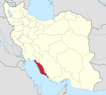
Bandar Genaveh (Persian: بندرگناوه; also Romanized as Bandar-e Genāveh, ; also known as Genāveh)[3] is a city in, and the capital of, the Central District of Ganaveh County, Bushehr province, Iran, and also serves as capital of the county.
At the 2006 census, its population was 59,291 in 12,548 households.[4] The following census in 2011 counted 64,110 people in 15,752 households.[5] As per the 2016 census, the population was 73,472 people in 19,977 households.[2]
Most of the population speak a dialect of Southern Lorish with some (in some case, great) influence from Bushehri speech. It is the place where the Persian Warlord, and founder of the Qarmatian State Abu Sa'id al-Jannabi originated from.[6] Ganaveh was historically famous for its pearl fishing and tiraz production, but it seems to have already been in decline by the 10th century.[7] The reason may have been because of the Qarmatian wars, or perhaps because of the lack of water supplies.[7] It had been the port of Bishapur and then Kazerun.[7]
YouTube Encyclopedic
-
1/2Views:568658
-
Iran, Bandare Genaveh (Ganaveh, Persian Gulf)
-
Old Genaveh
Transcription
See also
References
- ^ OpenStreetMap contributors (31 March 2023). "Bandar Ganaveh, Ganaveh County" (Map). OpenStreetMap. Retrieved 31 March 2023.
- ^ a b "Census of the Islamic Republic of Iran, 1395 (2016)". AMAR (in Persian). The Statistical Center of Iran. p. 18. Archived from the original (Excel) on 3 August 2017. Retrieved 19 December 2022.
- ^ Bandar Ganaveh can be found at GEOnet Names Server, at this link, by opening the Advanced Search box, entering "-3063352" in the "Unique Feature Id" form, and clicking on "Search Database".
- ^ "Census of the Islamic Republic of Iran, 1385 (2006)". AMAR (in Persian). The Statistical Center of Iran. p. 18. Archived from the original (Excel) on 20 September 2011. Retrieved 25 September 2022.
- ^ "Census of the Islamic Republic of Iran, 1390 (2011)". Syracuse University (in Persian). The Statistical Center of Iran. p. 18. Archived from the original (Excel) on 3 April 2023. Retrieved 19 December 2022.
- ^ Carra de Vaux, B. & Hodgson, M. G. S. (1965). "al-D̲j̲annābī, Abū Saʿīd Ḥasan b. Bahrām". In Lewis, B.; Pellat, Ch. & Schacht, J. (eds.). The Encyclopaedia of Islam, New Edition, Volume II: C–G. Leiden: E. J. Brill. p. 452. OCLC 495469475.
- ^ a b c Christensen, Peter (1993). The decline of Iranshahr: irrigation and environments in the history of the Middle East, 500 BC to AD 1500. Museum Tusculanum Press. p. 175. ISBN 9781838609351.


