
Bagha
বাঘা | |
|---|---|
 Bagha Mosque | |
 | |
| Coordinates: 24°11.5′N 88°50′E / 24.1917°N 88.833°E | |
| Country | |
| Division | Rajshahi |
| District | Rajshahi |
| Thana | 23 March 1983 |
| Upazila | 14 September 1983 |
| Government | |
| • MP (Rajshahi-6) | Shahriar Alam |
| • Upazila Chairman | Muhammad Layeb Uddin Lavlu |
| Area | |
| • Total | 185.16 km2 (71.49 sq mi) |
| Population (2011) | |
| • Total | 184,183 |
| • Density | 990/km2 (2,600/sq mi) |
| Time zone | UTC+6 (BST) |
| Website | bagha |
Bagha (Bengali: বাঘা) is an upazila of the Rajshahi District, located in Bangladesh's Rajshahi Division.[1]
YouTube Encyclopedic
-
1/4Views:1 3696354 3891 482
-
Just Go, বাঘা রাজশাহী, Bagha tour Rajshahi, toto company tour bangla
-
৫০ টাকার নোট এর বিখ্যাত বাঘা মসজিদ, bagha mosque, rajshahi, top masjid in bangladesh, Rajshahi Vlog
-
Utsob Park (Bagha Rajshahi), Bangladesh
-
Biography of Bangladeshi Actor Bidda Sinha Saha Mim - Lifestyle, Boyfriend, Income & Unknown Facts
Transcription
Geography
Bagha is located at 24°11′30″N 88°50′00″E / 24.1917°N 88.8333°E. It has 46,711 households and total area 185.16 km2.
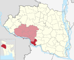
Bagha Upazila is bounded by Charghat Upazila and Bagatipara Upazila, the latter in Natore District, on the north, Lalpur and Bagatipara Upazilas, both in Natore District, on the east, Daulatpur Upazila in Kushtia District, on the south and Jalangi CD Block, in Murshidabad district, West Bengal, India, on the west.[2]
History

Alaypur village of Bagha was the headquarters of Laskar Khan Jaigirdar during the sixteenth century. Hazrat Shah Doulah settled at Bagha and started preaching Islam after being granted 42 parganas by the rulers.[3] He also established a famous madrasa here.[1] Bagha thana of present-day Rajshahi district was a thriving centre of learning in the early Muslim period. The place became famous after Shah Muazzam Danishmand (Maulana Shah Daula) from Baghdad settled there during the reign of the Sultan of Bengal Nasiruddin Nasrat Shah (1519–32) and built his khanqah there. An inscription table of the time of Sultan Nusrat Shah was discovered there that records the construction of a Jam’i mosque in 930 A.H. (1523-24 A.D.) One Abdul Latif visited the Bagha madrasah in 1609. There he met an elderly Sufi named Hawadah Main (Maulana Hamid Danishmand) son of Maulana Shah Daula, who was running a madrasah and a khanqah in a peaceful environment. Probably the madrasah was established during the reign of Nusrat Shah.[4]
During the Bangladesh Liberation War of 1971, temporary camps were founded by the Pakistan Army in places such as Narayanpur, Bagha, Pakuria, Arani, Alaipur and Chawkrajapur and many brawls took place in these camps against the 400 Bengali freedom fighters of Bagha. 7 of these freedom fighters has been martyr.[1]
Demographics
According to the 2011 Bangladesh census, Bagha Upazila had 46,711 households and a population of 184,183. 35,215 (19.12%) were under 10 years of age. Bagha had a literacy rate (age 7 and over) of 49.65%, compared to the national average of 51.8%, and a sex ratio of 1002 females per 1000 males. 44,173 (23.98%) lived in urban areas.[5][6]
Administration
Bagha Upazila is divided into two Municipal Corporations and seven Union Parishads.
Municipal Corporations:
- Arani Municipality
- Bagha Municipality
Union Parishads:
- Arani
- Bajubagha
- Bausa
- Gargari
- Manigram
- Pakuria
- Chakrajapur
The union parishads are subdivided into 99 mauzas and 78 villages.[5]
Chairmen
| Number | Name | Started |
|---|---|---|
| 01 | Muhammad Abdul Aziz | 15/8/1985 |
| 02 | Muhammad Bayezul Islam Khan | 18/2/1990 |
| 03 | Muhammad Bayezul Islam Khan | 23/2/2009 |
| 04 | Muhammad Layeb Uddin Labhlu | Present |
Economy and tourism

Bagha Upazila is home to 343 mosques, most notably the ancient Bagha Mosque complex which also contains the mazar (mausoleum) of Shah Dawlah, a key figure who propagated Islam in the region. The mazar of Dilal Bukhari is in Alaipur. The indigo factory (nilkuthi) at Mirganj is a relic of the colonial period and is currently used as a silk factory.[1] Bagha Museum is also a tourist spot of Bagha Upazila.

Education
There a number of madrasas in Bagha Upazila which provide educational services to the local community. Some of these include:[7]
| Name | Headteacher |
|---|---|
| Darul Uloom Dakhil Madrasa | Muhammad Yunus Ali |
| Parsaota Alim Madrasa | Muhammad Bazlul Karim |
| Bagha Fazil Madrasa | Muhammad Abdul Ghafur Miah |
| Bausha Hedatipara Dakhil Madrasa | Muhammad Abdur Rashid |
| Arani Dakhil Madrasa | Muhammad Abu Hanif |
| Arani Chakarpara Dakhil Madrasa | Muhammad Shamimuzzaman |
| Sultanpur Gorasthan Dakhil Madrasa | Muhammad Abdul Mannaf |
| Jot Qadirpur Dakhil Madrasa | Mosammat Rafiyah Sultanah |
| Manigram Dakhil Madrasa | Muhammad Tahurul Islam |
Notable people
- Shahriar Alam, MP, the State Minister for Foreign Affairs of the People's Republic of Bangladesh.
- Polan Sarkar, social activist.
- Nazmul Hoque Sarkar, lawyer.
See also
- Upazilas of Bangladesh
- Districts of Bangladesh
- Divisions of Bangladesh
- Shah Makhdum Rupos, medieval Iraqi saint who visited the area
References
- ^ a b c d AKM Kaisaruzzaman (2012). "Bagha Upazila". In Sirajul Islam; Miah, Sajahan; Khanam, Mahfuza; Ahmed, Sabbir (eds.). Banglapedia: the National Encyclopedia of Bangladesh (Online ed.). Dhaka, Bangladesh: Banglapedia Trust, Asiatic Society of Bangladesh. ISBN 984-32-0576-6. OCLC 52727562. OL 30677644M. Retrieved 1 February 2024.
- ^ "Tehsil Map of Murshidabad". CD Block/ Tehsil. Maps of India. Retrieved 15 November 2018.
- ^ বাঘা মাজার [Bagha Mazar]. Bagha Upazila (in Bengali).
- ^ Shakir, SAT (2012-06-30). "Islamic Education in Early Islamic Bengal". Clio:Jahangirnagar University Journal of the Department of History. 29.
- ^ a b c "Bangladesh Population and Housing Census 2011 Zila Report – Rajshahi" (PDF). bbs.gov.bd. Bangladesh Bureau of Statistics.
- ^ "Community Tables: Rajshahi district" (PDF). bbs.gov.bd. Bangladesh Bureau of Statistics. 2011.
- ^ বাঘা উপজেলার মাদ্রাসার তালিকা [Bagha Upazila's madrasa list]. Bagha Upazila (in Bengali).
External links
| Upazila/Thana: | ||
|---|---|---|
Headquarters: Rajshahi | ||
| Bogra District |  | |
| Joypurhat District | ||
| Naogaon District | ||
| Natore District | ||
| Nawabganj District | ||
| Pabna District | ||
| Rajshahi District | ||
| Sirajganj District | ||