
 | |
 Bacon Island  Bacon Island  Bacon Island | |
| Geography | |
|---|---|
| Location | Northern California |
| Coordinates | 37°58′36″N 121°33′08″W / 37.976590°N 121.552174°W[1] |
| Adjacent to | San Joaquin River |
| Administration | |
| State | |
| County | Sacramento |
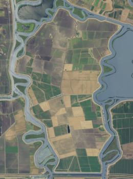
Bacon Island is an island in the Sacramento-San Joaquin River Delta, twenty kilometres east of Antioch, and twenty kilometres west of Stockton.[2] The 2,200 ha (5,400-acre) island is bounded on the west by Old River, on the north by Connection Slough, on the east by Middle River, and Woodward Island Canal on the south.[3] It is in San Joaquin County, and managed by Reclamation District 2028.[4] It appears on 1913 and 1952 United States Geological Survey maps of the area.[5][6]
The island is owned by the Metropolitan Water District of Southern California.[7]
See also
References
- ^ U.S. Geological Survey Geographic Names Information System: Bacon Island
- ^ "Bond Men Visit Phillips Company's Island Holdings". The Evening Mail. Stockton, California. 1913-01-11. p. 6.
- ^ Woodward Island, Bacon Island, Page 036 (San Joaquin County 1911) Historic Map Works, Residential Genealogy
- ^ "Municipal Service Review: Selected San Joaquin County Reclamation Districts" (PDF). San Joaquin Local Agency Formation Commission. E Mulberg & Associates. 18 March 2018. Archived from the original (PDF) on 14 March 2021. Retrieved 24 February 2021.
- ^ Marshall, R.B.; Gerdine, T.G.; Hannegan, Duncan; Lewis, J.L. (1913). "Topography, State of California: Woodward Island Quadrangle". United States Geological Survey. Archived from the original on 5 April 2020. Retrieved 25 February 2021.
- ^ United States Geological Survey (1952). "Woodward Island Quadrangle, California" (Map). United States Department of the Interior Geological Survey. 1:24000.
- ^ https://www.mwdh2o.com/delta-islands-and-habitat-restoration/
Map: Islands of Suisun Bay and the Sacramento–San Joaquin River Delta | |
|---|---|
 |

This San Joaquin County, California–related article is a stub. You can help Wikipedia by expanding it. |