
Baâlons | |
|---|---|
 The road into Baâlons | |
 Coat of arms | |
Location of Baâlons  | |
 Baâlons  Baâlons | |
| Coordinates: 49°35′42″N 4°40′16″E / 49.595°N 4.6711°E | |
| Country | France |
| Region | Grand Est |
| Department | Ardennes |
| Arrondissement | Charleville-Mézières |
| Canton | Nouvion-sur-Meuse |
| Intercommunality | Crêtes Préardennaises |
| Government | |
| • Mayor (2020–2026) | Raoul Charbonneaux[1] |
| Area 1 | 14.72 km2 (5.68 sq mi) |
| Population (2021)[2] | 206 |
| • Density | 14/km2 (36/sq mi) |
| Time zone | UTC+01:00 (CET) |
| • Summer (DST) | UTC+02:00 (CEST) |
| INSEE/Postal code | 08041 /08430 |
| 1 French Land Register data, which excludes lakes, ponds, glaciers > 1 km2 (0.386 sq mi or 247 acres) and river estuaries. | |
Baâlons (French pronunciation: [balɔ̃]) is a commune in the Ardennes department in the Grand Est region of northern France.
YouTube Encyclopedic
-
1/2Views:2 8249 375
-
Nakhun Aur Baalon Ke Muamlay Mein Iss Ghalt Fahmi Se Zarur Bachay? by Adv Faiz Syed @CallToALLAH
-
Isai Ladki Se Nikah | Na Mard Shohar | Zere Naaf Baalon Ki Safaye | Maulana Makki Al Hijazi
Transcription
Geography
Baâlons is located some 25 km north-east of Rethel and 18 km south of Charleville-Mézières. Access to the commune is by the D28 road from Bouvellemont in the south which passes through the village and continues north-east then north to join the D27. The D991 also goes north from Bouvellemont passing through the west of the commune to join the D951 north of Mazerny. The commune is mixed forest and farmland with particularly large forests in the east.
The Ruisseau du Fond Cahors rises west of the village and flows west to join the Ruisseau de la Fontaine aux Chênes. The Ruisseau des Puiselets forms the western border of the commune as it flows south to join the Ruisseau du Fond Cahors. The Ruisseau de Baâlons rises in the north of the commune and flows south towards the village then turns east to join the Ruisseau de Bairon on the eastern border. The Ruisseau de Bairon forms the eastern border of the commune as it flows south to join the Étang de Bairon which feeds into the Canal des Ardennes west of Tannay.[3]
Hamlets and localities in the commune

- Géraumont
Géraumont was a former fief where there is still a castle, now Géromont Farm.
- Les Puiselets
A small hamlet west of Baâlons village. It is now very sparsely populated however the General Dictionary of cities towns, villages, hamlets and farms of France by Duclos says that in 1846 there were 70 inhabitants.[4]
- Beauvois
A Hamlet in the north of the commune which is still populated.
Neighbouring communes and villages
Places adjacent to Baâlons | |
|---|---|
History
Various objects have been found in the commune:[6]
- Tools and shards of flint which are probably Neolithic
- Gallo-Roman Bronze Statuettes of Mars and Jupiter
- A Merovingian and Carolingian Cemetery
The Universal Dictionary of Ancient and Modern France and New France by Marin Saugrain stated in 1726 that:[7]
"BAALON in Champagne, Diocese of Reims, Parliament of Paris, Intendance of Chalons, Election of Rhetel, has 419 inhabitants. The Curate is worth nine hundred livres.".
Heraldry
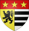 |
Blazon: Parti per pale: 1 Or a lion Sable, 2 Argent with 3 fesses Sable; the whole in chief Gules charged with 3 mullets Or.
|
Administration

| From | To | Name |
|---|---|---|
| 2001 | 2008 | Ludovic Dasnois |
| 2008 | 2012 | Henri Charpentier |
| 2012 | 2020 | Pascal Nihotte |
| 2020 | Current | Raoul Charbonneaux |
Population
The inhabitants of the commune are known as Baâlonnais or Baâlonnaises in French.[9]
|
| ||||||||||||||||||||||||||||||||||||||||||||||||||||||||||||||||||||||||||||||||||||||||||||||||||||||||||||
| Source: EHESS[10] and INSEE[11] | |||||||||||||||||||||||||||||||||||||||||||||||||||||||||||||||||||||||||||||||||||||||||||||||||||||||||||||

Sites and Monuments

- The Church of Saint-Rémi is a church dating to the 13th century in the late Romanesque style with a tympanum over the door from the 10th century representing a man with a crosier and an open book flanked by two angels. The church contains two items which are registered as historical objects:
- The Chapel of Saint Anne was built in 1911 on the site of a chapel dating from 1807 near the Saint Anne spring which was a place of pilgrimage. The Procession of Saint Anne is held on 26 July of each year.
- Church and Chapel Picture Gallery
-
 The Church of Saint-Rémi
 -
 The facade of the Church
 -
 The door to the Church
 -
 The Tympanum
 -
 Stained glass in the Church
 -
 A Wayside Cross
 -
 The chapel of Saint Anne
 -
 The Altar in the Chapel
 -
 An Oratory at the Chapel of Saint Anne
 -
 Strained glass in the Chapel
Notable people linked to the commune
- Eugène Houssière, emigrated to Louisiana USA in 1883, donated the Chapel of Saint Anne in 1911.
See also
References
- ^ "Répertoire national des élus: les maires". data.gouv.fr, Plateforme ouverte des données publiques françaises (in French). 2 December 2020.
- ^ "Populations légales 2021". The National Institute of Statistics and Economic Studies. 28 December 2023.
- ^ Google Maps
- ^ Duclos, Dictionnaire général des villes bourgs, villages, hameaux et fermes de la France, 4th ed., Paris & Limoges : Martial Ardent frères, p.387 (in French)
- ^ Géoportail, IGN (in French)
- ^ Archives MAE, GA0107 FR MAESA GA 55/1 (in French)
- ^ Marin Saugrain, Dictionnaire universel de la France ancienne et moderne et de la Nouvelle France, Paris, 1726, t.1, p.271 (in French)
- ^ List of Mayors of France (in French)
- ^ Le nom des habitants du 08 - Ardennes, habitants.fr
- ^ Des villages de Cassini aux communes d'aujourd'hui: Commune data sheet Baâlons, EHESS (in French).
- ^ Population en historique depuis 1968, INSEE
- ^ Ministry of Culture, Palissy PM08000044 Group Sculpture: Saint Nicolas (in French)

- ^ Ministry of Culture, Palissy PM08000043 Statue: Virgin and child (in French)
External links
- Baâlons
- Baâlons on the old National Geographic Institute website
- Baâlons on Géoportail, National Geographic Institute (IGN) website (in French)
- Baalon on the 1750 Cassini Map
| Authority control databases: National |
|---|