
KML is from Wikidata
Bath | |
|---|---|
 BA | |
| Coordinates: 51°13′19″N 2°25′16″W / 51.222°N 2.421°W | |
| Country | United Kingdom |
| Postcode area | BA |
| Postcode area name | Bath |
| Post towns | 16 |
| Postcode districts | 19 |
| Postcode sectors | 81 |
| Postcodes (live) | 15,136 |
| Postcodes (total) | 19,944 |
| Statistics as at May 2020[1] | |
The BA postcode area, also known as the Bath postcode area,[2] is a group of nineteen postcode districts in South West England, within sixteen post towns. These cover east Somerset (including Bath, Yeovil, Bruton, Castle Cary, Frome, Glastonbury, Radstock, Shepton Mallet, Street, Templecombe, Wells and Wincanton) and west Wiltshire (including Bradford on Avon, Trowbridge, Warminster and Westbury), plus very small parts of north-west Dorset and south Gloucestershire.
YouTube Encyclopedic
-
1/5Views:41 854 384115 53251 7892 977 1751 740 021
-
Swimming with SHARKS! Overcoming Fear!
-
Postcode Meaning
-
How to Plan Multiple Stops on Google Maps | Pete the Courier Driver
-
Inside The Richest Zip Code In The US
-
How to find the Area and Perimeter of a Rectangle
Transcription
Coverage
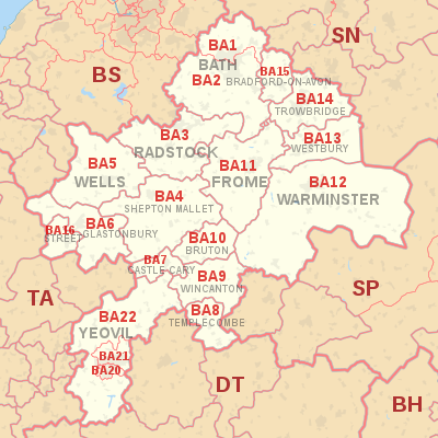
The approximate coverage of the postcode districts:
| Postcode district | Post town | Coverage | Local authority area(s) |
|---|---|---|---|
| BA1 | BATH | Bath north of the Avon, Batheaston, Bathford, Swainswick | Bath and North East Somerset, South Gloucestershire |
| BA2 | BATH | Bath south of the Avon, Farmborough, Timsbury, Peasedown St John, Wellow, Hinton Charterhouse, Norton St Philip, Freshford, Limpley Stoke | Bath and North East Somerset, Somerset, Wiltshire |
| BA3 | RADSTOCK | Radstock, Midsomer Norton, Holcombe, Coleford | Bath and North East Somerset, Somerset |
| BA4 | SHEPTON MALLET | Shepton Mallet, Evercreech | Somerset |
| BA5 | WELLS | Wells, Wookey, Westbury-sub-Mendip | Somerset |
| BA6 | GLASTONBURY | Glastonbury, Baltonsborough, Meare, Westhay | Somerset |
| BA7 | CASTLE CARY | Castle Cary, Ansford, Alford, Lovington | Somerset |
| BA8 | TEMPLECOMBE | Templecombe, Henstridge, Horsington | Somerset |
| BA9 | BRUTON | non-geographic[3][4] | |
| BA9 | WINCANTON | Wincanton, Penselwood, Cucklington, Holton, Yarlington | Somerset |
| BA10 | BRUTON | Bruton, Pitcombe, Redlynch, Brewham | Somerset |
| BA11 | FROME | Frome, Beckington | Somerset |
| BA12 | WARMINSTER | Warminster, Mere, Corsley, Zeals, Kilmington | Wiltshire |
| BA13 | WESTBURY | Westbury, Chapmanslade | Wiltshire |
| BA14 | TROWBRIDGE | Trowbridge | Wiltshire |
| BA15 | BRADFORD-ON-AVON | Bradford-on-Avon, Winsley, Westwood, Monkton Farleigh, South Wraxall | Wiltshire |
| BA16 | STREET | Street, Walton | Somerset |
| BA20 | YEOVIL | Yeovil (centre and south) | Somerset |
| BA21 | YEOVIL | Yeovil (north), Mudford | Somerset, Dorset |
| BA22 | YEOVIL | Yeovil (west), East Coker, West Coker, Ilchester, Sparkford, Marston Magna, Halstock, Stoford, Clifton Maybank | Somerset, Dorset |
Map
KML is from Wikidata
See also
References
- ^ "ONS Postcode Directory Version Notes" (ZIP). National Statistics Postcode Products. Office for National Statistics. May 2020. Table 2. Retrieved 19 June 2020. Coordinates from mean of unit postcode points, "Code-Point Open". OS OpenData. Ordnance Survey. February 2012. Retrieved 21 April 2012.
- ^ Royal Mail, Address Management Guide, (2004)
- ^ "Non Geographic Codes" (PDF). Royal Mail Address Management Unit. July 2012. Archived from the original (PDF) on 16 September 2012. Retrieved 25 October 2012.
- ^ "New sectors and localities to 19 October 2012" (PDF). Royal Mail Address Management Unit. 19 October 2012. Archived from the original (PDF) on 13 May 2013. Retrieved 25 October 2012.