To install click the Add extension button. That's it.
The source code for the WIKI 2 extension is being checked by specialists of the Mozilla Foundation, Google, and Apple. You could also do it yourself at any point in time.
How to transfigure the Wikipedia
Would you like Wikipedia to always look as professional and up-to-date? We have created a browser extension. It will enhance any encyclopedic page you visit with the magic of the WIKI 2 technology.
Try it — you can delete it anytime.
Install in 5 seconds
Yep, but later
4,5
Kelly Slayton
Congratulations on this excellent venture… what a great idea!
Alexander Grigorievskiy
I use WIKI 2 every day and almost forgot how the original Wikipedia looks like.
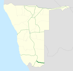
B3 is a national highway of Namibia. It passes through the ǁKaras Region of Namibia in the south for 179 kilometres (111 mi), connecting the B1 at Grünau to the South African border at Nakop via the town of Karasburg. In South Africa the highway continues as the N10 towards Upington.[1]
YouTube Encyclopedic
1/1
Views:
59 412
Road Traffic Signs ▶️ Episode 3: COMMAND SIGNS (Regulatory Signs | K53 Learners Licence South Africa