
Aurangabad Division
Marathwada | |
|---|---|
| Chhatrapati Sambhajinagar Division | |
 Aurangabad | |
| Coordinates: 19°53′19.63″N 75°20′36.37″E / 19.8887861°N 75.3434361°E | |
| Country | |
| State | |
| Districts | |
| Government | |
| • Commissioner Aurangabad Division |
|
| • Police Commissioner Aurangabad Division | NA |
| • All Guardian Minister Aurangabad Division |
|
| • All District Collector's Aurangabad Division |
|
| • All MP's Aurangabad Division | NA |
| Area | |
| • Total | 64,590.58 km2 (24,938.56 sq mi) |
| Population (2011)[1] | |
| • Total | 18,731,872 |
| Languages[2] | |
| • Language | Marathi (official) Urdu Hindi Lambadi |
| Literacy | 76.49%[1] |
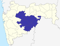
Aurangabad division, officially known as Chhatrapati Sambhajinagar division[3] is one of the six administrative divisions of Maharashtra state in India. It represents the Marathwada region of Maharashtra and is synonymous with it.
YouTube Encyclopedic
-
1/5Views:1 65416 2103 08011 9105 619
-
औरंगाबाद प्रशासकीय विभाग | Aurangabad Administrative Department #mpsc #geography #aurangabad
-
Top Pharmacy colleges in Marathwada Aurangabad Division
-
Aurangabad Division Cut-off & Waiting list || Finance Department Result 2019 ||
-
Top 10 Government Polytechnic Colleges In Marathwada Aurangabad Division
-
'Aarambh' Aurangabad Division Training
Transcription
Demographics
Aurangabad Division has total area of 64,590 km2 and had a population of 18,731,872 at the time of the 2011 census of India.[4][a]
Languages
At the time of the 2011 Census of India, the territory making up Aurangabad Division had a variety of languages. 77.98% of the population spoke Marathi, 9.56% Urdu, 6.49% Hindi and 3.20% Lambadi as their first language.[5]
Religion
Hinduism is the majority religion in Aurangabad Division, with Islam and Buddhism being significant minorities. In urban areas of Aurangabad Division, the Muslim population exceeds 25%, notably in cities such as Aurangabad itself, where it stands at around 30%. This is higher than the division's average population of 18%. Sikhism has a significant presence in Nanded, meanwhile Jains are present in urban areas of Marathwada such as Auranabad, Jalna and Osmanabad.
At the time of the 2011 Census of India, 76.68% of the population of Aurangabad Division followed Hinduism, 15.13% Islam, 7.17% Buddhism, 0.22% Christianity and the remaining 0.81% of the population followed other religions or stated no religion.[6][b]
Religion in Aurangabad Division (2011)[6]
Districts
Notes
- ^ Aurangabad Division is not separate political or administrative entity so there is no reference of population by name of "Aurangabad Division", population has been calculated by adding population of 8 districts of Aurangabad Division.
- ^ Aurangabad Division is not separate political or administrative entity so there is no reference of population by name of "Aurangabad Division", population for each religion has been calculated by adding population of 8 districts of Aurangabad Division.
References
- ^ a b c "District wise Demography". Census 2011. Retrieved 23 May 2015.
- ^ "Aurangabad division languages(Marathwada region)". www.censusindia.gov.in. Census of India 2011.
- ^ "Aurangabad formally renamed Chhatrapati Sambhajinagar, Osmanabad as Dharashiv". Hindustan Times. 16 September 2023.
- ^ "Maharashtra Population Census data 2011". Government of India. Retrieved 11 April 2015.
- ^ 2011 Census of India, Population By Mother Tongue
- ^ a b "PCA REL: Primary Census Abstract - By religion, Maharashtra". Office of the Registrar General & Census Commissioner, India. 2011.
| Topics | |||||||||||||
|---|---|---|---|---|---|---|---|---|---|---|---|---|---|
| Regions | |||||||||||||
| Divisions and Districts |
| ||||||||||||
| Million-plus cities in Maharashtra | |||||||||||||
| Other cities with municipal corporations | |||||||||||||
| Governmant | |||||||||||||
This article about a location in the Indian state of Maharashtra is a stub. You can help Wikipedia by expanding it. |
This Aurangabad district, Maharashtra, India location article is a stub. You can help Wikipedia by expanding it. |