
Saint-Nazaire | |
|---|---|
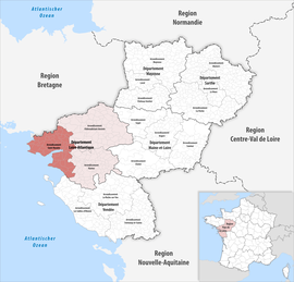 Location within the region Pays de la Loire | |
| Country | France |
| Region | Pays de la Loire |
| Department | Loire-Atlantique |
| No. of communes | 55 |
| Subprefecture | Saint-Nazaire |
| Area | 1,758.1 km2 (678.8 sq mi) |
| Population (Jan. 2020)[1] | 341,649 |
| • Density | 194/km2 (500/sq mi) |
| INSEE code | 443 |
The arrondissement of Saint-Nazaire is an arrondissement of France in the Loire-Atlantique department in the Pays de la Loire region. It has 55 communes.[2] Its population is 327,907 (2016), and its area is 1,758.1 km2 (678.8 sq mi).[3]
Composition
The communes of the arrondissement of Saint-Nazaire, and their INSEE codes, are:[2]
- Assérac (44006)
- Batz-sur-Mer (44010)
- La Baule-Escoublac (44055)
- La Bernerie-en-Retz (44012)
- Besné (44013)
- Bouée (44019)
- Campbon (44025)
- La Chapelle-Launay (44033)
- La Chapelle-des-Marais (44030)
- Chaumes-en-Retz (44005)
- Chauvé (44038)
- Corsept (44046)
- Le Croisic (44049)
- Crossac (44050)
- Donges (44052)
- Drefféac (44053)
- Frossay (44061)
- Guenrouet (44068)
- Guérande (44069)
- Herbignac (44072)
- Lavau-sur-Loire (44080)
- Malville (44089)
- Mesquer (44097)
- Missillac (44098)
- Montoir-de-Bretagne (44103)
- Les Moutiers-en-Retz (44106)
- Paimbœuf (44116)
- Piriac-sur-Mer (44125)
- La Plaine-sur-Mer (44126)
- Pontchâteau (44129)
- Pornic (44131)
- Pornichet (44132)
- Le Pouliguen (44135)
- Préfailles (44136)
- Prinquiau (44137)
- Quilly (44139)
- Saint-André-des-Eaux (44151)
- Saint-Brevin-les-Pins (44154)
- Sainte-Anne-sur-Brivet (44152)
- Sainte-Reine-de-Bretagne (44189)
- Saint-Gildas-des-Bois (44161)
- Saint-Hilaire-de-Chaléons (44164)
- Saint-Joachim (44168)
- Saint-Lyphard (44175)
- Saint-Malo-de-Guersac (44176)
- Saint-Michel-Chef-Chef (44182)
- Saint-Molf (44183)
- Saint-Nazaire (44184)
- Saint-Père-en-Retz (44187)
- Saint-Viaud (44192)
- Savenay (44195)
- Sévérac (44196)
- Trignac (44210)
- La Turballe (44211)
- Villeneuve-en-Retz (44021)
History
The arrondissement of Savenay was created in 1800. The subprefecture was moved to Saint-Nazaire in 1868.[4]
As a result of the reorganisation of the cantons of France which came into effect in 2015, the borders of the cantons are no longer related to the borders of the arrondissements. The cantons of the arrondissement of Saint-Nazaire were, as of January 2015:[5]
- La Baule-Escoublac
- Bourgneuf-en-Retz
- Le Croisic
- Guérande
- Herbignac
- Montoir-de-Bretagne
- Paimboeuf
- Pontchâteau
- Pornic
- Saint-Gildas-des-Bois
- Saint-Nazaire-Centre
- Saint-Nazaire-Est
- Saint-Nazaire-Ouest
- Saint-Père-en-Retz
- Savenay
References
- ^ "Téléchargement du fichier d'ensemble des populations légales en 2020". The National Institute of Statistics and Economic Studies. 29 December 2022.
- ^ a b "Arrondissement de Saint-Nazaire (443)". INSEE. Retrieved 2019-10-01.
- ^ "Comparateur de territoire, géographie au 01/01/2019". INSEE. Retrieved 2019-10-01.
- ^ Historique de la Loire-Atlantique
- ^ "Populations légales 2012: 44 Loire-Atlantique" (PDF). INSEE. December 2014. Retrieved 1 April 2022.
47°17′N 2°12′W / 47.28°N 2.20°W