
Montmorillon | |
|---|---|
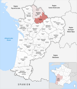 Location within the region Nouvelle-Aquitaine | |
| Country | France |
| Region | Nouvelle-Aquitaine |
| Department | Vienne |
| No. of communes | 90 |
| Subprefecture | Montmorillon |
| Area | 2,876.1 km2 (1,110.5 sq mi) |
| Population (2021)[1] | 65,756 |
| • Density | 23/km2 (60/sq mi) |
| INSEE code | 862 |
The arrondissement of Montmorillon is an arrondissement of France in the Vienne department in the Nouvelle-Aquitaine region. It has 90 communes.[2] Its population is 67,025 (2016), and its area is 2,876.1 km2 (1,110.5 sq mi).[3]
Composition
The communes of the arrondissement of Montmorillon, and their INSEE codes, are:[2]
- Adriers (86001)
- Anché (86003)
- Antigny (86006)
- Asnières-sur-Blour (86011)
- Asnois (86012)
- Availles-Limouzine (86015)
- Béthines (86025)
- Blanzay (86029)
- Bouresse (86034)
- Bourg-Archambault (86035)
- Brigueil-le-Chantre (86037)
- Brion (86038)
- Brux (86039)
- La Bussière (86040)
- Champagné-le-Sec (86051)
- Champagné-Saint-Hilaire (86052)
- Champniers (86054)
- La Chapelle-Bâton (86055)
- Chapelle-Viviers (86059)
- Charroux (86061)
- Chatain (86063)
- Château-Garnier (86064)
- Chaunay (86068)
- Civaux (86077)
- Civray (86078)
- Coulonges (86084)
- La Ferrière-Airoux (86097)
- Fleix (86098)
- Gençay (86103)
- Genouillé (86104)
- Gouex (86107)
- Haims (86110)
- L'Isle-Jourdain (86112)
- Jouhet (86117)
- Journet (86118)
- Joussé (86119)
- Lathus-Saint-Rémy (86120)
- Lauthiers (86122)
- Leignes-sur-Fontaine (86126)
- Lhommaizé (86131)
- Liglet (86132)
- Linazay (86134)
- Lizant (86136)
- Luchapt (86138)
- Lussac-les-Châteaux (86140)
- Magné (86141)
- Mauprévoir (86152)
- Mazerolles (86153)
- Millac (86159)
- Montmorillon (86165)
- Moulismes (86170)
- Moussac (86171)
- Mouterre-sur-Blourde (86172)
- Nalliers (86175)
- Nérignac (86176)
- Paizay-le-Sec (86187)
- Payroux (86189)
- Persac (86190)
- Pindray (86191)
- Plaisance (86192)
- Pressac (86200)
- Queaux (86203)
- Romagne (86211)
- Saint-Gaudent (86220)
- Saint-Germain (86223)
- Saint-Laurent-de-Jourdes (86228)
- Saint-Léomer (86230)
- Saint-Martin-l'Ars (86234)
- Saint-Maurice-la-Clouère (86235)
- Saint-Pierre-de-Maillé (86236)
- Saint-Pierre-d'Exideuil (86237)
- Saint-Romain (86242)
- Saint-Savin (86246)
- Saint-Secondin (86248)
- Saulgé (86254)
- Savigné (86255)
- Sillars (86262)
- Sommières-du-Clain (86264)
- Surin (86266)
- Thollet (86270)
- La Trimouille (86273)
- Usson-du-Poitou (86276)
- Val-de-Comporté (86247)
- Valdivienne (86233)
- Valence-en-Poitou (86082)
- Verrières (86285)
- Le Vigeant (86289)
- Villemort (86291)
- Voulême (86295)
- Voulon (86296)
History
The arrondissement of Montmorillon was created in 1800.[4] At the January 2017 reorganisation of the arrondissements of Vienne, it lost one commune to the arrondissement of Châtellerault and four communes to the arrondissement of Poitiers.[5]
As a result of the reorganisation of the cantons of France which came into effect in 2015, the borders of the cantons are no longer related to the borders of the arrondissements. The cantons of the arrondissement of Montmorillon were, as of January 2015:[6]
- Availles-Limouzine
- Charroux
- Chauvigny
- Civray
- Couhé
- Gençay
- L'Isle-Jourdain
- Lussac-les-Châteaux
- Montmorillon
- Saint-Savin
- La Trimouille
References
- ^ "Téléchargement du fichier d'ensemble des populations légales en 2021". The National Institute of Statistics and Economic Studies. 28 December 2023.
- ^ a b "Arrondissement de Montmorillon (862)". INSEE. Retrieved 2019-10-04.
- ^ "Comparateur de territoire, géographie au 01/01/2019". INSEE. Retrieved 2019-10-04.
- ^ Historique de la Vienne
- ^ "Arrêté préfectoral, 30 December 2016" (PDF). pp. 142–147. Retrieved 2019-10-28.
- ^ Populations légales 2012: 86 Vienne, INSEE
46°26′N 0°52′E / 46.43°N 0.87°E