
Châteaudun | |
|---|---|
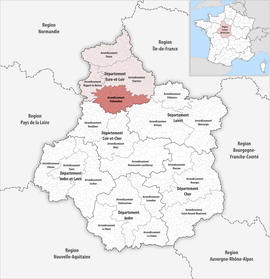 Location within the region Centre-Val de Loire | |
| Country | France |
| Region | Centre-Val de Loire |
| Department | Eure-et-Loir |
| No. of communes | 61 |
| Subprefecture | Châteaudun |
| Area | 1,438.8 km2 (555.5 sq mi) |
| Population (Jan. 2020)[1] | 57,604 |
| • Density | 40/km2 (100/sq mi) |
| INSEE code | 282 |
The arrondissement of Châteaudun is an arrondissement of France in the Eure-et-Loir department in the Centre-Val de Loire region. It has 61 communes.[2] Its population is 59,262 (2016), and its area is 1,438.8 km2 (555.5 sq mi).[3]
YouTube Encyclopedic
-
1/1Views:2 872
-
Rue de Charonne Paris Arrondissement 11e
Transcription
Composition
The communes of the arrondissement of Châteaudun, and their INSEE codes, are:[2]
- Alluyes (28005)
- Baigneaux (28019)
- Bazoches-en-Dunois (28028)
- Bazoches-les-Hautes (28029)
- Bonneval (28051)
- Bouville (28057)
- Brou (28061)
- Bullainville (28065)
- La Chapelle-du-Noyer (28075)
- Châteaudun (28088)
- Cloyes-les-Trois-Rivières (28103)
- Conie-Molitard (28106)
- Cormainville (28108)
- Courbehaye (28114)
- Dambron (28121)
- Dampierre-sous-Brou (28123)
- Dancy (28126)
- Dangeau (28127)
- Donnemain-Saint-Mamès (28132)
- Flacey (28153)
- Fontenay-sur-Conie (28157)
- Le Gault-Saint-Denis (28176)
- Gohory (28182)
- Guillonville (28190)
- Jallans (28198)
- Logron (28211)
- Loigny-la-Bataille (28212)
- Lumeau (28221)
- Marboué (28233)
- Meslay-le-Vidame (28246)
- Moléans (28256)
- Montboissier (28259)
- Montharville (28260)
- Moriers (28270)
- Mottereau (28272)
- Neuvy-en-Dunois (28277)
- Nottonville (28283)
- Orgères-en-Beauce (28287)
- Péronville (28296)
- Poupry (28303)
- Pré-Saint-Évroult (28305)
- Pré-Saint-Martin (28306)
- Saint-Avit-les-Guespières (28326)
- Saint-Christophe (28329)
- Saint-Denis-Lanneray (28334)
- Saint-Maur-sur-le-Loir (28353)
- Sancheville (28364)
- Saumeray (28370)
- Terminiers (28382)
- Thiville (28389)
- Tillay-le-Péneux (28390)
- Trizay-lès-Bonneval (28396)
- Unverre (28398)
- Vald'Yerre (28012)
- Varize (28400)
- Vieuvicq (28409)
- Villampuy (28410)
- Villemaury (28330)
- Villiers-Saint-Orien (28418)
- Vitray-en-Beauce (28419)
- Yèvres (28424)
History
The arrondissement of Châteaudun was created in 1800.[4]
As a result of the reorganisation of the cantons of France which came into effect in 2015, the borders of the cantons are no longer related to the borders of the arrondissements. The cantons of the arrondissement of Châteaudun were, as of January 2015:[5]
- Bonneval
- Brou
- Châteaudun
- Cloyes-sur-le-Loir
- Orgères-en-Beauce
References
- ^ "Téléchargement du fichier d'ensemble des populations légales en 2020". The National Institute of Statistics and Economic Studies. 29 December 2022.
- ^ a b "Arrondissement de Châteaudun (282)". INSEE. Retrieved 2019-09-29.
- ^ "Comparateur de territoire, géographie au 01/01/2019". INSEE. Retrieved 2019-09-29.
- ^ Historique d'Eure-et-Loir
- ^ Populations légales 2012: 28 Eure-et-Loir, INSEE
48°04′N 1°19′E / 48.067°N 1.317°E