
Carpentras | |
|---|---|
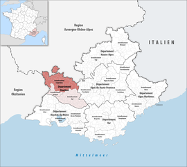 Location within the region Provence-Alpes-Côte d'Azur | |
| Country | France |
| Region | Provence-Alpes-Côte d'Azur |
| Department | Vaucluse |
| No. of communes | 77 |
| Subprefecture | Carpentras |
| Area | 1,807.0 km2 (697.7 sq mi) |
| Population (Jan. 2020)[1] | 224,408 |
| • Density | 124/km2 (320/sq mi) |
| INSEE code | 843 |
The arrondissement of Carpentras is an arrondissement of France in the Vaucluse department in the Provence-Alpes-Côte d'Azur region. It has 77 communes.[2] Its population is 215,881 (2016), and its area is 1,807.0 km2 (697.7 sq mi).[3]
YouTube Encyclopedic
-
1/3Views:3 96011 758694
-
Carpentras-Sorgues : premier jour de circulation
-
Trains en France:Vieille ligne desaffectée Avignon-Carpentras à Monteux.
-
Aux pieds de Pierre, le Canal de Carpentras !
Transcription
Composition
The communes of the arrondissement of Carpentras, and their INSEE codes, are:[2]
- Althen-des-Paluds (84001)
- Aubignan (84004)
- Aurel (84005)
- Le Barroux (84008)
- Le Beaucet (84011)
- Beaumes-de-Venise (84012)
- Beaumont-du-Ventoux (84015)
- Bédoin (84017)
- Blauvac (84018)
- Bollène (84019)
- Brantes (84021)
- Buisson (84022)
- Caderousse (84027)
- Cairanne (84028)
- Camaret-sur-Aigues (84029)
- Caromb (84030)
- Carpentras (84031)
- Châteauneuf-du-Pape (84037)
- Crestet (84040)
- Crillon-le-Brave (84041)
- Entrechaux (84044)
- Faucon (84045)
- Flassan (84046)
- Gigondas (84049)
- Grillon (84053)
- Jonquières (84056)
- Lafare (84059)
- Lagarde-Paréol (84061)
- Lamotte-du-Rhône (84063)
- Lapalud (84064)
- Loriol-du-Comtat (84067)
- Malaucène (84069)
- Malemort-du-Comtat (84070)
- Mazan (84072)
- Méthamis (84075)
- Modène (84077)
- Mondragon (84078)
- Monieux (84079)
- Monteux (84080)
- Mormoiron (84082)
- Mornas (84083)
- Orange (84087)
- Pernes-les-Fontaines (84088)
- Piolenc (84091)
- Puyméras (84094)
- Rasteau (84096)
- Richerenches (84097)
- Roaix (84098)
- La Roque-Alric (84100)
- La Roque-sur-Pernes (84101)
- Sablet (84104)
- Saint-Christol (84107)
- Saint-Didier (84108)
- Sainte-Cécile-les-Vignes (84106)
- Saint-Hippolyte-le-Graveyron (84109)
- Saint-Léger-du-Ventoux (84110)
- Saint-Marcellin-lès-Vaison (84111)
- Saint-Pierre-de-Vassols (84115)
- Saint-Romain-en-Viennois (84116)
- Saint-Roman-de-Malegarde (84117)
- Saint-Trinit (84120)
- Sarrians (84122)
- Sault (84123)
- Savoillan (84125)
- Séguret (84126)
- Sérignan-du-Comtat (84127)
- Suzette (84130)
- Travaillan (84134)
- Uchaux (84135)
- Vacqueyras (84136)
- Vaison-la-Romaine (84137)
- Valréas (84138)
- Venasque (84143)
- Villedieu (84146)
- Villes-sur-Auzon (84148)
- Violès (84149)
- Visan (84150)
History
The arrondissement of Carpentras was created in 1800.[4] At the January 2017 reorganisation of the arrondissements of Vaucluse, it received 21 communes from the arrondissement of Avignon, and it lost two communes to the arrondissement of Avignon.[5]
As a result of the reorganisation of the cantons of France which came into effect in 2015, the borders of the cantons are no longer related to the borders of the arrondissements. The cantons of the arrondissement of Carpentras were, as of January 2015:[6]
References
- ^ "Téléchargement du fichier d'ensemble des populations légales en 2020". The National Institute of Statistics and Economic Studies. 29 December 2022.
- ^ a b "Arrondissement de Carpentras (843)". INSEE. Retrieved 2019-10-04.
- ^ "Comparateur de territoire, géographie au 01/01/2019". INSEE. Retrieved 2019-10-04.
- ^ "Historique de Vaucluse". Site sur la Population et les Limites Administratives de la France (in French). Archived from the original on 3 March 2016. Retrieved 22 December 2020.
- ^ "Arrêté préfectoral, 20 December 2016" (PDF). pp. 11–15. Archived from the original (PDF) on 7 August 2017. Retrieved 2019-10-28.
- ^ Populations légales 2012: 84 Vaucluse, INSEE
44°03′N 5°03′E / 44.05°N 5.05°E