
Ariany
Ariañy | |
|---|---|
Municipality and town | |
 Parish Church of Nuestra Señora de Atocha | |
 Seal | |
 Municipal location | |
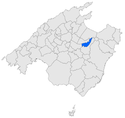
 Ariany Location of the town in Majorca  Ariany Ariany (Balearic Islands)  Ariany Ariany (Spain) | |
| Coordinates: 39°38′58″N 3°6′39″E / 39.64944°N 3.11083°E | |
| Country | |
| Autonomous Community | Balearic Islands |
| Province | Balearic Islands |
| Island | Majorca |
| Comarca | Pla de Mallorca |
| Government | |
| • Mayor (2007-) | Joan Ribot Mayol |
| Area | |
| • Total | 8.93 sq mi (23.14 km2) |
| Elevation | 407 ft (124 m) |
| Population (2018)[1] | |
| • Total | 860 |
| • Density | 96/sq mi (37/km2) |
| Time zone | UTC+1 (CET) |
| • Summer (DST) | UTC+2 (CEST) |
| Website | http://www.ajariany.net |
Ariany (Catalan pronunciation: [əɾiˈaɲ]) is a small municipality on Majorca, one of the Balearic Islands, Spain. It has an area of 22.72 km ² with 839 inhabitants in 2008, 763 of which lived in the main town. In 2006, the foreign population of the municipality was 10.4% (80 people).
History
Archeological findings show that the surrounding villages were present in prehistoric times. James I of Aragon first referred to the settlement with its current name. From the sixteenth century it was subject to the Cotoner family, owners of the land in Ariany. The current population center was developed around the manor house of the Auberg's, named S'Auberg i El Camí de Sa Marquesa. Other main buildings today include the Parish Church of Nuestra Señora de Atocha (built in 1570) and Ca ses Monges, the convent of Franciscan nuns.
References
- ^ Municipal Register of Spain 2018. National Statistics Institute.
39°39′N 3°06′E / 39.650°N 3.100°E
This article about a location in the Balearic Islands is a stub. You can help Wikipedia by expanding it. |