
Arab Zahrat al-Dumayri
عرب ظهرة الضميري Dumeira, al[1] | |
|---|---|
 1870s map 1870s map  1940s map 1940s map modern map modern map  1940s with modern overlay map 1940s with modern overlay mapA series of historical maps of the area around Arab Zahrat al-Dumayri (click the buttons) | |
 Arab Zahrat al-Dumayri Location within Mandatory Palestine | |
| Coordinates: 32°27′31″N 34°54′24″E / 32.45861°N 34.90667°E | |
| Palestine grid | 141/207 |
| Geopolitical entity | Mandatory Palestine |
| Subdistrict | Haifa |
| Date of depopulation | April 10, 1948[1] |
| Population (1945) | |
| • Total | 620[2][3] |
| Cause(s) of depopulation | Expulsion by Yishuv forces |
Arab Zahrat al-Dumayri was a Palestinian Arab village in the Haifa Subdistrict. It was depopulated during the 1947–1948 Civil War in Mandatory Palestine on April 10, 1948. It was located 40 km south of Haifa.
History
In the 1922 census of Palestine, conducted by the British Mandate authorities, Al Damaireh had a population of 227 Muslims.[4]
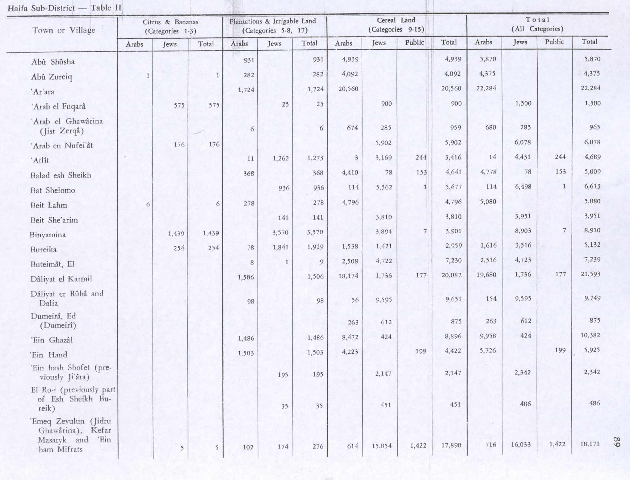
The population in the 1945 statistics was 620, all Muslims,[2] with a total of 1,387 dunams of land according to an official land and population survey.[3] Of this, Arabs used 263 dunams for cereals,[5] while a total of 512 dunams were non-cultivable land.[6]
On 6 April 1948, the Haganah implemented a new policy for the coastal plains, namely of clearing the whole area of its Arab inhabitants. On 10 April the villagers of Arab Zahrat al-Dumayri, together with the villagers of Arab al-Fuqara and Arab al-Nufay'at, were ordered to leave the area.[7]
References
- ^ a b Morris, 2004, p. xviii, village #179. Also gives cause of depopulation
- ^ a b Government of Palestine, Department of Statistics, 1945, p. 13
- ^ a b Government of Palestine, Department of Statistics. Village Statistics, April, 1945. Quoted in Hadawi, 1970, p. 47
- ^ Barron, 1923, Table XI, Sub-district of Haifa, p. 35
- ^ Government of Palestine, Department of Statistics. Village Statistics, April, 1945. Quoted in Hadawi, 1970, p. 89
- ^ Government of Palestine, Department of Statistics. Village Statistics, April, 1945. Quoted in Hadawi, 1970, p. 139
- ^ Morris, 2004, p. 245, note631
Bibliography
- Barron, J.B., ed. (1923). Palestine: Report and General Abstracts of the Census of 1922. Government of Palestine.
- Government of Palestine, Department of Statistics (1945). Village Statistics, April, 1945.
- Hadawi, S. (1970). Village Statistics of 1945: A Classification of Land and Area ownership in Palestine. Palestine Liberation Organization Research Center.
- Khalidi, W. (1992). All That Remains: The Palestinian Villages Occupied and Depopulated by Israel in 1948. Washington D.C.: Institute for Palestine Studies. ISBN 0-88728-224-5.
- Morris, B. (2004). The Birth of the Palestinian Refugee Problem Revisited. Cambridge University Press. ISBN 978-0-521-00967-6.
External links
- Welcome To 'Arab Zahrat al-Dumayri
- 'Arab Zahrat al-Dumayri, from Zochrot
- Survey of Western Palestine, Map 7: IAA, Wikimedia commons
- Arab Zahrat al-Dumayri from the Khalil Sakakini Cultural Center

This geography of the State of Palestine article is a stub. You can help Wikipedia by expanding it. |