
Aoukar
عوكر | |
|---|---|
 Landscape in the Ayoun el Atrous area | |
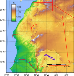 Location of the Aoukar basin in Mauritania | |
| Country | Mauritania |
| Elevation | 240 m (790 ft) |
Aoukar or Erg Aoukar[1] (Arabic: عوكر) is a geological depression area of south eastern Mauritania. It is located between Kiffa and Néma, south of the Tagant Plateau. The region is also referred to as Hodh or El Hodh[5] (Arabic: الحوض, lit. 'the Basin').[3]
The Aoukar basin is a dry natural region of sand dunes and salt pans fringed by escarpments on its northern and eastern sides.
YouTube Encyclopedic
-
1/1Views:36 751
-
Strainer Bowl, Caveman Factory, designer Ryann Aoukar
Transcription
History
There was once vast reed-covered endorheic lake in the area, but it no longer exists. The former lake of Aoukar extended towards the area of Tichit, bordering the southern edge of the Tagant Plateau. Below the cliffs (dhars) facing the extinct lake remains of about 400 villages have been found.[6][7]

From east to west, Dhar Néma, Dhar Walata, Dhar Tichitt, and Dhar Tagant form a semicircular shape around the Hodh/Aoukar Depression, which, prior to 4000 BCE, was an area with lakes of considerable size, and, after 1000 BCE, was an area that had become increasingly dried.[8] During the emergence of the Tichitt Tradition, it was an oasis area.[8] The Tichitt Tradition of eastern Mauritania dates from 2200 BCE[9][10] to 200 BCE.[11][12]
Previously administered as part of French Sudan (present-day Mali), the area was transferred to French Mauritania in 1944, apparently on a whim of the colonial governor Laigret.[13] The transfer was still resented upon Mali's independence.[14] Formerly more fertile, it is now largely a barren waste.[15]
Aoukar/Hodh gave its name to the modern Mauritanian regions of Hodh Ech Chargui and Hodh El Gharbi.
Ecology
The Aoukar is one of the few natural refuges for the addax, a critically endangered kind of antelope which lives in the region.[16]
See also
References
- ^ Marco Stoppato, Alfredo Bini (2003), Deserts, p. 156
- ^ Fāsī, Muḥammad & al. General History of Africa, Vol. III: Africa from the Seventh to the Eleventh Century, p. 130. UNESCO (Paris), 1988. Accessed 18 Apr 2014.
- ^ a b Barth, Henry. Travels and Discoveries in North and Central Africa, being a Journal of an Expedition undertaken under the Auspices of H.B.M.'s Government, in the Years 1849–1855, Vol. 3, pp. 712 ff. Harper & Bros. (New York), 1859. Accessed 18 Apr 2014.
- ^ Ould-Mey, Mohameden. Global Restructuring and Peripheral States: The Carrot and the Stick in Mauritania, p. 66. Rowman & Littlefield (Lanham), 1996. Accessed 18 Apr 2014.
- ^ Also encountered as Hōdh, Ḥawḍ,[2] Hódh,[3] and al-Hodh.[4]
- ^ "Tichit - The living ghost of yesterday's glory". Archived from the original on 2016-03-04. Retrieved 2014-08-13.
- ^ G. Marcus and B. de Valicourt (2000). Mauritanie, p. 10
- ^ a b MacDonald, Kevin C.; Vernet, Robert; Martinón-Torres, Marcos; Fuller, Dorian Q. (April 2009). "Dhar Néma: from early agriculture to metallurgy in southeastern Mauritania". Azania: Archaeological Research in Africa. 44 (1): 3–48. doi:10.1080/00671990902811330.
- ^ McDougall, E. Ann (2019). "Saharan Peoples and Societies". Oxford Research Encyclopedia of African History. doi:10.1093/acrefore/9780190277734.013.285. ISBN 978-0-19-027773-4.
- ^ Holl, Augustin F.C. (25 June 2009). "Coping with uncertainty: Neolithic life in the Dhar Tichitt-Walata, Mauritania, (ca. 4000–2300 BP)". Comptes Rendus. Géoscience. 341 (8–9): 703–712. Bibcode:2009CRGeo.341..703H. doi:10.1016/j.crte.2009.04.005.
- ^ MacDonald, K.; Vernet, R. (2007). Early domesticated pearl millet in Dhar Nema (Mauritania): evidence of crop processing waste as ceramic temper. Netherlands: Barkhuis. pp. 71–76. ISBN 9789077922309.
- ^ Kay, Andrea U. (2019). "Diversification, Intensification and Specialization: Changing Land Use in Western Africa from 1800 BC to AD 1500". Journal of World Prehistory. 32 (2): 179–228. doi:10.1007/s10963-019-09131-2. hdl:10230/44475. S2CID 134223231.
- ^ Lalonde, Suzanne. Determining Boundaries in a Conflicted World: The Role of Uti Possidetis, p. 109. McGill-Queen's University Press (Montreal), 2002. Accessed 18 Apr 2014.
- ^ Touval, Saadia. The Boundary Politics of Independent Africa, p. 247. iUniverse, 1999. ISBN 1583484221. Accessed 18 Apr 2014.
- ^ Morgan, William & al. West Africa, pp. 254 ff. Methuen, 1973.
- ^ Richard Trillo, The Rough Guide to West Africa
External links
18°00′N 9°30′W / 18.000°N 9.500°W