To install click the Add extension button. That's it.
The source code for the WIKI 2 extension is being checked by specialists of the Mozilla Foundation, Google, and Apple. You could also do it yourself at any point in time.
How to transfigure the Wikipedia
Would you like Wikipedia to always look as professional and up-to-date? We have created a browser extension. It will enhance any encyclopedic page you visit with the magic of the WIKI 2 technology.
Try it — you can delete it anytime.
Install in 5 seconds
Yep, but later
4,5
Kelly Slayton
Congratulations on this excellent venture… what a great idea!
Alexander Grigorievskiy
I use WIKI 2 every day and almost forgot how the original Wikipedia looks like.
Dirigindo até Antônio Carlos - Santa Catarina - Giro Floripa
Descubra Santa Catarina 2015
Entrada Antônio Carlos/SC a partir da BR 101 vindo do Norte ou Sul
Transcription
Regional language
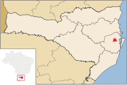
A local variety of the Hunsrückisch dialect (see: West Germanic languages) has been spoken and is part of the history of this region since pioneer days starting almost two centuries ago. Hunsrückisch is a co-official language of this municipality. Elsewhere, mostly in the western part of Santa Catarina state, but especially in the neighboring state of Rio Grande do Sul, the predominant German dialect is the Riograndenser Hunsrückisch variety of the same language group. (See also: Pennsylvania German language, a mutually intelligible variety of German spoken in the United States and Canada).
^"Divisão Territorial do Brasil" (in Portuguese). Divisão Territorial do Brasil e Limites Territoriais, Instituto Brasileiro de Geografia e Estatística (IBGE). July 1, 2008. Retrieved December 17, 2009.