
Alton, Iowa | |
|---|---|
 St. Mary's Catholic Church | |
 Location of Alton, Iowa | |
| Coordinates: 42°59′13″N 96°0′41″W / 42.98694°N 96.01139°W | |
| Country | |
| State | |
| County | Sioux |
| Incorporated | March 8, 1883 |
| Area | |
| • Total | 1.90 sq mi (4.93 km2) |
| • Land | 1.90 sq mi (4.93 km2) |
| • Water | 0.00 sq mi (0.00 km2) |
| Elevation | 1,325 ft (404 m) |
| Population (2020) | |
| • Total | 1,248 |
| • Density | 656.15/sq mi (253.33/km2) |
| Time zone | UTC-6 (Central (CST)) |
| • Summer (DST) | UTC-5 (CDT) |
| ZIP code | 51003 |
| Area code | 712 |
| FIPS code | 19-01585 |
| GNIS feature ID | 0454157 |
| Website | City of Alton |
Alton is a city in Sioux County, Iowa, United States, along the Floyd River. The population was 1,248 at the 2020 census.[2]
History
Alton was originally called East Orange, and under the latter name was laid out in 1875 when the railroad was extended to that point.[3] East Orange was renamed Alton in 1882.[4] Alton was incorporated as a city in 1883.[3]
Geography
Alton is located at 42°59′13″N 96°00′41″W / 42.986906°N 96.011314°W (42.986906, -96.011314).[5]
According to the United States Census Bureau, the city has a total area of 1.85 square miles (4.79 km2), all land.[6]
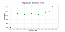
Demographics
| Year | Pop. | ±% |
|---|---|---|
| 1890 | 708 | — |
| 1900 | 1,009 | +42.5% |
| 1910 | 1,046 | +3.7% |
| 1920 | 1,007 | −3.7% |
| 1930 | 1,014 | +0.7% |
| 1940 | 1,025 | +1.1% |
| 1950 | 1,038 | +1.3% |
| 1960 | 1,048 | +1.0% |
| 1970 | 1,018 | −2.9% |
| 1980 | 986 | −3.1% |
| 1990 | 1,063 | +7.8% |
| 2000 | 1,095 | +3.0% |
| 2010 | 1,216 | +11.1% |
| 2020 | 1,248 | +2.6% |
| Source:"U.S. Census website". United States Census Bureau. Retrieved March 28, 2020. and Iowa Data Center Source: | ||
2010 census
As of the census[8] of 2010, there were 1,216 people, 478 households, and 338 families living in the city. The population density was 657.3 inhabitants per square mile (253.8/km2). There were 493 housing units at an average density of 266.5 per square mile (102.9/km2). The racial makeup of the city was 95.9% White, 0.7% African American, 0.3% Native American, 0.7% Asian, 1.6% from other races, and 0.8% from two or more races. Hispanic or Latino of any race were 4.7% of the population.
There were 478 households, of which 33.9% had children under the age of 18 living with them, 63.6% were married couples living together, 4.4% had a female householder with no husband present, 2.7% had a male householder with no wife present, and 29.3% were non-families. 24.9% of all households were made up of individuals, and 12.1% had someone living alone who was 65 years of age or older. The average household size was 2.54 and the average family size was 3.07.
The median age in the city was 36.6 years. 27.1% of residents were under the age of 18; 7.5% were between the ages of 18 and 24; 23.2% were from 25 to 44; 28.3% were from 45 to 64; and 13.7% were 65 years of age or older. The gender makeup of the city was 49.5% male and 50.5% female.
2000 census
As of the census[9] of 2000, there were 1,095 people, 439 households, and 297 families living in the city. The population density was 735.3 inhabitants per square mile (283.9/km2). There were 466 housing units at an average density of 312.9 per square mile (120.8/km2). The racial makeup of the city was 99.54% White, 0.09% Native American, 0.09% from other races, and 0.27% from two or more races. Hispanic or Latino of any race were 1.10% of the population.
There were 439 households, out of which 32.3% had children under the age of 18 living with them, 61.3% were married couples living together, 4.1% had a female householder with no husband present, and 32.3% were non-families. 30.1% of all households were made up of individuals, and 15.7% had someone living alone who was 65 years of age or older. The average household size was 2.49 and the average family size was 3.14.
In the city, the population was spread out, with 27.4% under the age of 18, 10.5% from 18 to 24, 26.4% from 25 to 44, 19.8% from 45 to 64, and 15.9% who were 65 years of age or older. The median age was 38 years. For every 100 females, there were 95.5 males. For every 100 females age 18 and over, there were 99.7 males.
The median income for a household in the city was $39,911, and the median income for a family was $47,143. Males had a median income of $30,500 versus $19,570 for females. The per capita income for the city was $16,663. About 4.0% of families and 4.2% of the population were below the poverty line, including 2.4% of those under age 18 and 11.3% of those age 65 or over.
Education
MOC-Floyd Valley Community School District is the local school district.[10] The district formed on July 1, 1994 with the merger of the Maurice-Orange City and Floyd Valley districts.[11] Alton houses the district's middle school while elementary and high schools are in Orange City.
Spalding Catholic School, which serves elementary grades, is located in a single campus in Alton. It was previously a K-8 school and had multiple campuses, with middle school in Granville, but the Granville campus closed in 2017, and middle school students are now attending Gehlen Catholic School in LeMars.[12] The associated Spalding Catholic High closed in 2013 with students merged into Gehlen Catholic High School.[13]
Notable person
- Robert Schuller, pastor of the Crystal Cathedral, was born and raised a few miles outside of Alton.[14]
References
- ^ "2020 U.S. Gazetteer Files". United States Census Bureau. Retrieved March 16, 2022.
- ^ a b "2020 Census State Redistricting Data". census.gov. United states Census Bureau. Retrieved August 12, 2021.
- ^ a b Savage, Tom (August 1, 2007). A Dictionary of Iowa Place-Names. University of Iowa Press. p. 23. ISBN 978-1-58729-759-5.
- ^ Chicago and North Western Railway Company (1908). A History of the Origin of the Place Names Connected with the Chicago & North Western and Chicago, St. Paul, Minneapolis & Omaha Railways. p. 36.
- ^ "US Gazetteer files: 2010, 2000, and 1990". United States Census Bureau. February 12, 2011. Retrieved April 23, 2011.
- ^ "US Gazetteer files 2010". United States Census Bureau. Archived from the original on January 25, 2012. Retrieved May 11, 2012.
- ^ "Census of Population and Housing". Census.gov. Retrieved June 4, 2015.
- ^ "U.S. Census website". United States Census Bureau. Retrieved May 11, 2012.
- ^ "U.S. Census website". United States Census Bureau. Retrieved January 31, 2008.
- ^ "MOC-Floyd Valley" (PDF). Iowa Department of Education. Archived from the original (PDF) on March 27, 2020. Retrieved March 27, 2020.
- ^ "REORGANIZATION & DISSOLUTION ACTIONS SINCE 1965-66" (PDF). Iowa Department of Education. Archived from the original (PDF) on February 9, 2019. Retrieved March 22, 2020.
- ^ Mahoney, Mark (December 6, 2017). "Spalding Catholic is all together". Nwestiowa.com. Iowa Information Publishers and Printers. Retrieved April 5, 2020.
- ^ Gausman, Kayah (August 22, 2013). "First bell rings for merged Gehlen, Spalding school". KTIV. Archived from the original on October 21, 2013. Retrieved October 8, 2013.
- ^ Penner, James, 'Goliath: The Life of Robert Schuller,' (1992), pg. 119
External links
- Alton, Iowa Portal style website, Government, Business, Recreation, and more
Municipalities and communities of Sioux County, Iowa, United States | ||
|---|---|---|
| Cities |  | |
| Unincorporated communities | ||
| Footnotes | ‡This populated place also has portions in an adjacent county or counties | |