


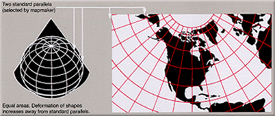
The Albers equal-area conic projection, or Albers projection (named after Heinrich C. Albers), is a conic, equal area map projection that uses two standard parallels. Although scale and shape are not preserved, distortion is minimal between the standard parallels.
YouTube Encyclopedic
-
1/5Views:3 6951 9106597 071507
-
Albers Equal Area Conic
-
Projection Profile: Lambert's Azimuthal Equal-Area
-
Working With 250-m NDVI Tiles in Alaska
-
MODIS Sensor and MODIS Land Products
-
Calculating Areas in ArcGIS Pro - Q:How many times bigger is Alaska than Texas? A:Which Projection!
Transcription
Official adoption
The Albers projection is used by some big countries as "official standard projection" for Census and other applications.
| Country | Agency |
|---|---|
| Brazil | federal government, through IBGE, for Census Statistical Grid [1] |
| Canada | government of British Columbia[2] |
| Canada | government of the Yukon[3] (sole governmental projection) |
| US | United States Geological Survey[4] |
| US | United States Census Bureau[4] |
Some "official products" also adopted Albers projection, for example most of the maps in the National Atlas of the United States.[5]
Formulas
For Sphere
Snyder[5] describes generating formulae for the projection, as well as the projection's characteristics. Coordinates from a spherical datum can be transformed into Albers equal-area conic projection coordinates with the following formulas, where is the radius, is the longitude, the reference longitude, the latitude, the reference latitude and and the standard parallels:


where

Lambert equal-area conic
If just one of the two standard parallels of the Albers projection is placed on a pole, the result is the Lambert equal-area conic projection.[6]
See also
References
- ^ "Grade Estatística" (PDF). 2016. Archived from the original (PDF) on 2018-02-19.
- ^ "Data Catalogue".
- ^ "Support & Info: Common Questions". Geomatics Yukon. Government of Yukon. Retrieved 15 October 2014.
- ^ a b "Projection Reference". Bill Rankin. Archived from the original on 25 April 2009. Retrieved 2009-03-31.
- ^ a b Snyder, John P. (1987). "Chapter 14: ALBERS EQUAL-AREA CONIC PROJECTION". Map Projections – A Working Manual. U.S. Geological Survey Professional Paper 1395. Washington, D.C.: United States Government Printing Office. p. 100. Archived from the original on 2008-05-16. Retrieved 2017-08-28.
- ^ "Directory of Map Projections". "Lambert equal-area conic".
External links
- Mathworld's page on the Albers projection
- Table of examples and properties of all common projections, from radicalcartography.net
- An interactive Java Applet to study the metric deformations of the Albers Projection.
This cartography or mapping term article is a stub. You can help Wikipedia by expanding it. |