
Aguni
粟国村 | |
|---|---|
Village | |
 Aerial view of Aguni Island | |
 Flag  Emblem | |
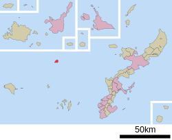 Location of Aguni in Okinawa Prefecture | |
 Aguni Location in Japan | |
| Coordinates: 26°34′57″N 127°13′38″E / 26.58250°N 127.22722°E | |
| Country | Japan |
| Region | Kyushu (Okinawa) |
| Prefecture | Okinawa Prefecture |
| District | Shimajiri |
| Government | |
| • Mayor | Shizuyoshi Shinjō |
| Area | |
| • Total | 7.65 km2 (2.95 sq mi) |
| Elevation | 97.3 m (319.2 ft) |
| Population (March 1, 2022) | |
| • Total | 672 |
| • Density | 88/km2 (230/sq mi) |
| Time zone | UTC+09:00 (JST) |
| City hall address | 367 Higashi, Aguni, Okinawa-ken |
| Climate | Cfa |
| Website | www |
| Symbols | |
| Flower | Easter Lily (Lilium longiflorum) |
| Tree | Fukugi (Garcinia) |
Aguni (粟国村, Aguni-son) is a village located in Shimajiri District, Okinawa Prefecture, Japan. The village occupies the entirety of Aguni Island.[1] As of 2022, the village had an estimated population of 672 and a population density of 87.8 persons per km2. The total area is 7.65 square kilometres (2.95 sq mi).[2]
YouTube Encyclopedic
-
1/3Views:1 1777992 112
-
Marine Landings on Aguni Island, Okinawa (May 5, 1945)
-
Aguni Island
-
台風18号/避難勧告発令中/瞬間最大風速の瞬間映像!
Transcription
Geography

Aguni is located in the East China Sea. The village sits 60 kilometres (37 mi) northwest of Naha, Okinawa, the prefectural capital of Okinawa on Okinawa Island. Aguni Island spans 3 kilometres (1.9 mi) from north to south and 4 kilometres (2.5 mi) from east to west. Aguni is a low-lying island with its highest point only reaching 97.3 metres (319 ft).[3][1]
Aguni faces Tonaki and the Kerama Islands to the south and Kume Island to the southwest. The town consists of three districts: Hama, Higashi, and Nishi.[3][1]
Climate
| Climate data for Aguni (2003−2020 normals, extremes 2003−present) | |||||||||||||
|---|---|---|---|---|---|---|---|---|---|---|---|---|---|
| Month | Jan | Feb | Mar | Apr | May | Jun | Jul | Aug | Sep | Oct | Nov | Dec | Year |
| Record high °C (°F) | 26.0 (78.8) |
26.4 (79.5) |
27.0 (80.6) |
28.8 (83.8) |
30.9 (87.6) |
33.7 (92.7) |
34.8 (94.6) |
35.3 (95.5) |
35.0 (95.0) |
32.9 (91.2) |
29.6 (85.3) |
28.2 (82.8) |
35.3 (95.5) |
| Mean daily maximum °C (°F) | 19.2 (66.6) |
20.1 (68.2) |
21.3 (70.3) |
23.9 (75.0) |
26.5 (79.7) |
29.2 (84.6) |
31.9 (89.4) |
31.8 (89.2) |
30.6 (87.1) |
27.8 (82.0) |
24.7 (76.5) |
21.0 (69.8) |
25.7 (78.2) |
| Daily mean °C (°F) | 17.0 (62.6) |
17.6 (63.7) |
18.6 (65.5) |
21.2 (70.2) |
23.9 (75.0) |
26.6 (79.9) |
29.0 (84.2) |
29.0 (84.2) |
28.0 (82.4) |
25.5 (77.9) |
22.6 (72.7) |
18.8 (65.8) |
23.2 (73.7) |
| Mean daily minimum °C (°F) | 14.7 (58.5) |
15.3 (59.5) |
16.2 (61.2) |
18.7 (65.7) |
21.6 (70.9) |
24.7 (76.5) |
26.7 (80.1) |
26.6 (79.9) |
25.7 (78.3) |
23.6 (74.5) |
20.6 (69.1) |
16.7 (62.1) |
20.9 (69.7) |
| Record low °C (°F) | 4.9 (40.8) |
5.6 (42.1) |
6.1 (43.0) |
10.3 (50.5) |
12.2 (54.0) |
17.0 (62.6) |
21.9 (71.4) |
22.4 (72.3) |
18.5 (65.3) |
15.7 (60.3) |
12.3 (54.1) |
7.2 (45.0) |
4.9 (40.8) |
| Average precipitation mm (inches) | 98.3 (3.87) |
103.5 (4.07) |
160.9 (6.33) |
154.0 (6.06) |
244.0 (9.61) |
334.3 (13.16) |
131.1 (5.16) |
182.0 (7.17) |
204.0 (8.03) |
116.5 (4.59) |
127.0 (5.00) |
106.3 (4.19) |
1,959.5 (77.15) |
| Average precipitation days (≥ 1.0 mm) | 11.3 | 10.9 | 11.3 | 10.7 | 12.0 | 12.7 | 6.9 | 9.9 | 10.6 | 8.2 | 8.8 | 10.1 | 123.4 |
| Source: JMA[4][5] | |||||||||||||
History
Aguni was settled early in the history of the Ryukyu Islands. The island has remains of both shell middens and gusuku castle remains. Aguni appears in the earliest written record as Awaguni, and was placed under the administration of Kume Island. Aguni was home to merchants and mariners in the sailing period of the Ryukyu Kingdom. After the end of the Ryukyu Kingdom, and the abolition of the han system in Japan in 1879, Aguni became part of Okinawa Prefecture. In 1880 the population of Aguni stood at 3,099 residents, and reached 4,966 by 1903. The island saw discontent and violent protest by peasants between 1880 and 1881, which were ultimately suppressed by the authorities on Kume Island. The Village of Aguni was formally established in 1908[3]
Aguni was invaded by the United States as part of the Battle of Okinawa during World War II. The island, along with the Kerama Islands, was overtaken by Allied forces after aerial and naval bombardment on March 23, 1945. Civil administration of the village ended after the American invasion. 30 leaders from the village were appointed to keep order on the island. The mayor of Aguni was reappointed in 1946 by the American administration, and mayoral and village council elections resumed in 1948.[3]
The population of Aguni decreased rapidly after World War II, due to both an aging population and the emigration of residents from the island. The village had 960 residents in 2000, and at present has fallen to 672.[3][2]
Government
Aguni is administered from the village hall in the Higashi district.
The Uruma City Council consists of 7 members who serve a four-year term, and are led by a chairperson (Fumio Tamayose) and vice-chairperson (Masanori Miyasato) of the council.[6]
Transportation

Air
Aguni is connected to Okinawa Island via Aguni Airport. The airport was constructed in 1978 after the reversion of Okinawa Prefecture to Japan. Aguni can be reached from Naha in only 20 minutes.[1][3]
Ferry
Aguni is connected to the main island of Okinawa by ferry between the Port of Aguni and the Port of Tomari in Naha. The Port of Aguni came under the administration of Okinawa Prefecture in 1972 after the reversion of the prefecture to Japan. Ferry service between Aguni and Naha takes approximately two hours.[1][3][7]
Education
- Aguni Kindergarten, Elementary, and Junior High School
References
- ^ a b c d e "粟国(村)" [Aguni]. Nihon Daihyakka Zensho (Nipponika) (in Japanese). Tokyo: Shogakukan. 2013. OCLC 153301537. Archived from the original on 2007-08-25. Retrieved 2013-01-31.
- ^ a b いまの粟国村 [Present-Day Aguni] (in Japanese). Aguni, Okinawa Prefecture, Japan: Village of Aguni. 2013. Retrieved 2013-06-19.
- ^ a b c d e f g "粟国島" [Aguni Island]. Nihon Rekishi Chimei Taikei (in Japanese). Tokyo: Shogakukan. 2013. OCLC 173191044. Archived from the original on 2007-08-25. Retrieved 2013-06-19.
- ^ 観測史上1~10位の値(年間を通じての値). JMA. Retrieved February 24, 2022.
- ^ 気象庁 / 平年値(年・月ごとの値). JMA. Retrieved February 24, 2022.
- ^ 議会 [Village Council] (in Japanese). Aguni, Okinawa Prefecture, Japan: Village of Aguni. 2013. Retrieved 2013-06-19.
- ^ "粟国(あぐに)港" [Port of Aguni]. Dijitaru Daijisen (in Japanese). Tokyo: Shogakukan. 2012. OCLC 56431036. Archived from the original on 2007-08-25. Retrieved 2012-12-14.
External links
![]() Media related to Aguni, Okinawa at Wikimedia Commons
Media related to Aguni, Okinawa at Wikimedia Commons
- Aguni official website (in Japanese)
| Core city | ||
|---|---|---|
| Cities | ||
| Districts | ||
| International | |
|---|---|
| National | |
| Geographic | |
| Academics | |
| Other | |