

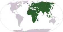
Afro-Eurasia (also Afroeurasia and Eurafrasia) is a landmass comprising the continents of Africa, Europe, and Asia. The terms are compound words of the names of its constituent parts. Afro-Eurasia has also been called the "Old World", in contrast to the "New World" referring to the Americas.
Afro-Eurasia encompasses 84,980,532 km2 (32,811,167 sq mi), 57% of the world's land area, and has a population of approximately 6.7 billion people, roughly 86% of the world population. Together with Australia, it comprises the vast majority of land in the world's Eastern Hemisphere. The Afro-Eurasian mainland is the largest and most populous contiguous landmass on Earth.
YouTube Encyclopedic
-
1/5Views:2 83654910 185 20790218 771
-
Afro Eurasia - More Grades 6-12 Social Studies on Harmony Square
-
Afro-Eurasian Civilizations Until 1 CE (The History Of Agrarian Civilizations Part 1 of 4)
-
What are Continents?
-
Class #35: Afro-Eurasia and the Four World Zones
-
Afro-Eurasians 💀⚔️💀 #europe #asia #africa #afroeurasia #countries #empires #history #geography #edit
Transcription
Related terms
The following terms are used for similar concepts:
- Ecumene: a term from classical antiquity for the world as was known to ancient Greek scholars, which was limited to Europe and parts of Africa and Asia.
- Old World: a term from the Age of Discovery which, for European explorers, contrasted their previously known world from the New World of the Americas.
- World Island: a term coined by H.J. Mackinder in his "The Geographical Pivot of History" (1904) and used in geopolitical contexts.[1] Mackinder defines the World Island as the large contiguous landmass, technically excluding islands such as Great Britain, the Malay Archipelago and the Japanese archipelago.[2] "Afro-Eurasia" generally includes those islands usually considered parts of Africa, Asia, and Europe.
Geology
Although Afro-Eurasia is typically considered to comprise two or three separate continents, it is not a proper supercontinent. Instead, it is the largest present part of the supercontinent cycle.[3]
Past
The oldest part of Afro-Eurasia is probably the Kaapvaal Craton, which together with Madagascar and parts of India and western Australia formed part of the first supercontinent Vaalbara or Ur around 3 billion years ago. It has made up parts of every supercontinent since. At the breakup of Pangaea around 200 million years ago, the North American and Eurasian Plates together formed Laurasia while the African Plate remained in Gondwana, from which the Indian Plate split off. Upon impact with the Eurasian Plate, the Indian Plate created southern Asia around 50 million years ago and began the formation of the Himalayas. Around the same time, the Indian Plate also fused with the Australian Plate.
The Arabian Plate broke off of Africa around 30 million years ago and impacted the Iranian Plate between 19 and 12 million years ago during the Miocene, ultimately forming the Alborz and Zagros chains of Iranian Plate. After this initial connection of Afro-Eurasia, the Betic corridor along the Gibraltar Arc closed a little less than 6 million years ago in the Messinian, fusing northwest Africa and Iberia together. This led to the nearly complete desiccation of the Mediterranean Basin, the Messinian salinity crisis. Eurasia and Africa were then again separated with the Zanclean Flood around 5.33 million years ago refilling the Mediterranean Sea through the Strait of Gibraltar.
Present
Today, the Eurasian Plate and African Plate dominate their respective continents. However, the Somali Plate covers much of eastern Africa, creating the East African Rift. In the eastern Mediterranean, the Aegean Sea Plate, Anatolian Plate and Arabian Plate also form a boundary with the African Plate, which incorporates the Sinai Peninsula, Gulf of Aqaba and the coastal Levant via the Dead Sea Transform. Eurasia also includes the Indian Plate, Burma Plate, Sunda Plate, Yangtze Plate, Amur Plate and Okhotsk Plate, with the North American Plate incorporating the Chukotka Autonomous Okrug in the Russian Far East.
Conventionally, Africa is joined to Eurasia only by a relatively narrow land bridge (which has been split by the Suez Canal at the Isthmus of Suez) and remains separated from Europe by the straits of Gibraltar and Sicily.
Future
Paleogeologist Ronald Blakey has described the next 15 to 100 million years of tectonic development as fairly settled and predictable.[4] In that time, Africa is expected to continue drifting northward. It will close the Strait of Gibraltar,[5] quickly evaporating the Mediterranean Sea.[6] No supercontinent will form within the settled time frame, however, and the geologic record is full of unexpected shifts in tectonic activity that make further projections "very, very speculative".[4] Three possibilities are known as Novopangaea, Amasia, and Pangaea Proxima.[7] In the first two, the Pacific closes and Africa remains fused to Eurasia, but Eurasia itself splits as Africa and Europe spin towards the west; in the last, the trio spin eastward together as the Atlantic closes, creating land borders with the Americas.
Extreme points
This is a list of the points that are farther north, south, east or west than any other location as well as the highest and lowest elevations on Afro-Eurasia.
Mainland
- Easternmost Point — Cape Dezhnev†, Russia
- Northernmost Point — Cape Chelyuskin, Russia
- Southernmost Point — Cape Agulhas, South Africa
- Westernmost Point — Pointe des Almadies, Senegal
Including islands
- Easternmost Point — Big Diomede†, Russia
- Northernmost Point — Cape Fligeli, Rudolf Island, Franz Josef Land, Russia
- Southernmost Point — Cape Agulhas, South Africa. If the Prince Edward Islands are included in Africa, then Marion Island is the southernmost point at 46°54'S.
- Westernmost Point — Santo Antão, Cape Verde
† The 180th meridian passes through Asia, meaning that these points are in the Western Hemisphere.
Elevation
• Highest Point – Mount Everest or Qomolangma, China and Nepal
• Lowest Point (on land) – Shores of the Dead Sea, between Israel and Jordan
See also
- Extreme points of Earth
- Extreme points of Africa
- Extreme points of Eurasia
- Geography of Africa
- Geography of Asia
- Geography of Europe
- Intermediate Region
- The Geographical Pivot of History
References
- ^ Mackinder, Halford John. The Geographical Pivot of History.
- ^ See Francis P. Sempa, Mackinder's World
- ^ Based upon 2019 population estimates from https://population.un.org/wpp/
- ^ a b Manaugh, Geoff (23 September 2013). "What Did the Continents Look Like Millions of Years Ago?". The Atlantic. Retrieved 22 July 2014.
- ^ "Future World". www.scotese.com.
- ^ Cloud, Preston (1988). Oasis in space. Earth history from the beginning. New York: W. W. Norton & Company Inc. p. 440. ISBN 0-393-01952-7.
Only the inflow of Atlantic water maintains the present Mediterranean level. When that was shut off sometime between 6.5 to 6 MYBP, net evaporative loss set in at the rate of around 3,300 cubic kilometers yearly. At that rate, the 3.7 million cubic kilometres of water in the basin would dry up in scarcely more than a thousand years, leaving an extensive layer of salt some tens of meters thick and raising global sea level about 12 meters.
- ^ Williams, Caroline; Nield, Ted (20 October 2007). "Pangaea, the comeback". New Scientist. Archived from the original on 13 April 2008. Retrieved 28 September 2009.
External links
- Interactive scholarly edition, with critical English translation and multimodal resources mashup (publications, images, videos) Engineering Historical Memory.
Continents of Earth | ||||||||
|---|---|---|---|---|---|---|---|---|
| ||||||||
| ||||||||


